isprs archives XLI B4 181 2016
Teks penuh
Gambar

Dokumen terkait
In the area of disaster risk reduction, NESAC has initiated operational services for early warning and post disaster assessment inputs for flood early warning system (FLEWS)
3) With the exception of most parts of Europe, South Africa, Iran, and Saudi Arabia, most other countries use satellite imagery for national data updating. Use of satellite
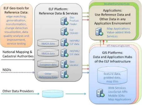
In order to optimize these data flows for the production of high quality geospatial information and to promote its use to address global challenges several initiatives at
Within this paper, we presented the current state of 3D data capture in urban areas by dense multi-view-stereo for different scenarios and camera configurations
In contrast to navigation and routing services on public streets, seamless navigation will cause an additional challenge: how to make routing data accessible to defined users
The New Horizons spacecraft flew past the Pluto system on 14 July 2015, and provided our first view of the geology and topography of Pluto and Charon by obtaining
The URBan land recycling Information services for Sustainable cities (URBIS) project aims for the development, implementation, and validation of web-based
location information to improve decision making and community outcomes. These figures cannot be extrapolated to the whole of Australia. GA as the National Mapping
