isprs archives XLI B4 25 2016
Teks penuh
Gambar
Dokumen terkait
The national ALS dataset and field data of the Swiss National Forest Inventory were used to calibrate estimation models for mean and maximum height, basal
Tree height-dbh model residuals probably reduce the correlation between lidar canopy height indices and ground AGB reference, consequently introducing errors to
This standard consists of four basic features to describe indoor cellular space; geometry and semantics of indoor cells, topology between indoor cells,
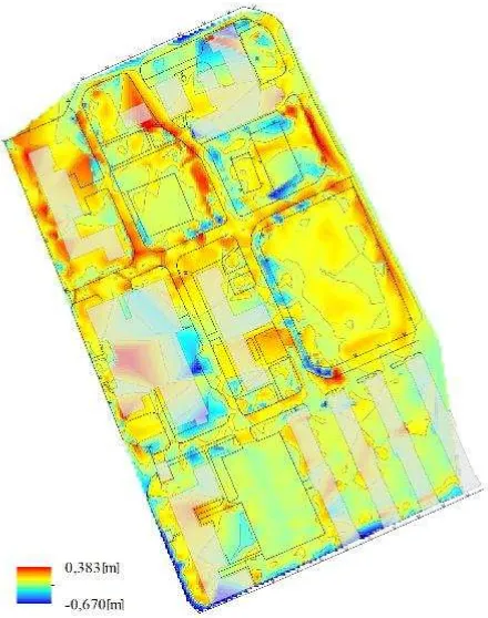
This mosaic used single-strip images and 3D points generated from individual strips as an input, which were subsequently passed by an elaborate processing chain,
Another example is proposed extension of FITS standard ( http://fits.gsfc.nasa.gov/fits_standard.html ), used in astronomy and astrophysics, to include metadata for
Moreover, this ICESat/GLAS system provides a consistently referenced elevation data set with unprecedented accuracy and quantified measurement errors that can be used to
In this paper, the analysis about low-frequency errors of the attitude determination system is performed, compensation models are proposed in bundle adjustment and the
The systematic height errors of the ZY3 DSM, based on orientation by bias correction with affine transformation, against the reference DSM from IGN (figure 2) are obvious – in
