isprs archives XLI B8 327 2016
Teks penuh
Gambar
Garis besar
Dokumen terkait
KEY WORDS: Urban Expansion, Remote Sensing, Landsat Imagery, Classification, Change Detection, Driven Forces Analysis, Montréal Census Metropolitan
The proposed method of tree growth estimation is based height measurements on point clouds generated from UAV imagery. The achieved accuracy is about
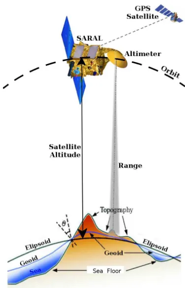
1 provides an overview of the SERAC processes to derive from laser altimetry data and DEMs complex information such as volume and mass balance change rates at individual
OPTIMAL BAND RATIO ANALYSIS OF WORLDVIEW-3 IMAGERY FOR BATHYMETRY OF SHALLOW RIVERS (CASE STUDY: SARCA RIVER, ITALY)M. Vitti
Differences between the numbers of affected people estimated based in SRTM and in remote sensing imagery show that uncertainty in the assessment of impacts of
3) With the exception of most parts of Europe, South Africa, Iran, and Saudi Arabia, most other countries use satellite imagery for national data updating. Use of satellite
We have used a set of Ground Control Points (GCPs) derived from altimetry measurements from the Ice, Cloud and land Elevation Satellite (ICESat) to evaluate the quality of the
Therefore, with more visible GLONASS satellites and the improved GLONASS precise satellite orbit and clock products in the future, the combined GR PPP will be expected
