isprsarchives XL 2 W3 47 2014
Teks penuh
Gambar
Garis besar
Dokumen terkait
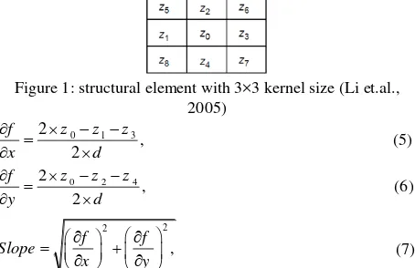
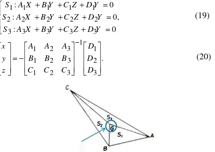
An algorithm for 3D reconstruction of the buildings based on LiDAR point cloud and aerial imagery is proposed which uses the advantage of both data sources,
Finally, the results obtained by the proposed classifier fusion system approach leads to higher classification accuracies compared to the single classifiers on hyperspectral and
In this study, feed forward neural network is used for time- series forecasting of the traffic related to the 301st day of 2008. We design this neural network for
Now, despite the efforts by NGO and NCC organizations in Iran, 1:25,000 maps cover the country with an independent data model has been produced that can be used as the basis
modification. In Table 3, the statistical characteristics of images before and after the vertical and diagonal striping noise removal are given. Slight reduction seen
To overcome the usual drawback of the low spatial resolution of aerial thermal infrared (TIR) images, resulting from low sensor resolution (here: 640x480 pixel) a
Each of these applications requires detailed and high quality input data from different sources like satellite data, aerial images and ground-based information from
In this work, we are exploring an alternative approach of using the Spark framework to scale out and distribute the processing of huge lidar datasets in a cloud computing
