isprsarchives XL 7 W4 159 2015
Teks penuh
Gambar
Garis besar
Dokumen terkait
In order to investigate the suitability of different input datasets for the classification of different land use / land cover types we also performed accuracy assessments for
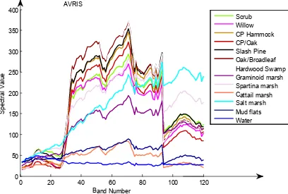
To observe response of the proposed method in a multitude of different landscape occurrences (natural settings) we have analysed reflectance relative error
The proposed method was able to improve the accuracy of the ground candidate points and virtual ground surface using point cloud of adjacent courses in the test area with thick
In this paper, a new fast image segmentation algorithm for high resolution remote sensing imagery is proposed, which is based on graph theory and fractal net
The Main task of matching results representation is to organize and store the related schema elements and the actual mapping between them achieved by schema matching, and to build
This paper presents a method of buildings reconstruction with stereo matching dense point clouds from aerial oblique images, which includes segmentation of buildings and
Figure 4: Based on an unsupervised segmentation, rule-based classification and data fusion process the developed algorithm managed to extract building footprints.. A
Due to the poor classification of the UAVs that now days is being used in Colombia, it is not allowed: To have a takeoff weight over the 25 kilograms, the
