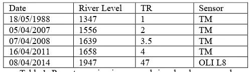
isprs archives XLI B8 159 2016
Teks penuh
Gambar

Dokumen terkait
Since the resolution of the nighttime light remote sensing data is very coarse and also exists the phenomenon of lighting overflow, the clipping area includes not
The International Archives of the Photogrammetry, Remote Sensing and Spatial Information Sciences, Volume XLI-B8, 2016 XXIII ISPRS Congress, 12–19 July 2016, Prague,
KEY WORDS: Unmanned aerial vehicle, satellite remote sensing, vegetation indices, winter wheat, site specific crop
The International Archives of the Photogrammetry, Remote Sensing and Spatial Information Sciences, Volume XLI-B8, 2016 XXIII ISPRS Congress, 12–19 July 2016, Prague,
The International Archives of the Photogrammetry, Remote Sensing and Spatial Information Sciences, Volume XLI-B8, 2016 XXIII ISPRS Congress, 12–19 July 2016, Prague,
The International Archives of the Photogrammetry, Remote Sensing and Spatial Information Sciences, Volume XLI-B8, 2016 XXIII ISPRS Congress, 12–19 July 2016, Prague,
The approach consists of four major steps: the extracting of missing residential area from the remote sensing images with high resolution; the statistic analysing on the size
The goal of this Rapid Information Products and Services (RIPS) Project, funded through the Canadian Space Agency, is to identify the contribution that remote
