isprsarchives XL 7 W3 441 2015
Teks penuh
Gambar
Garis besar
Dokumen terkait
In this study, Remote Sensing (RS) and Geographic Information Systems (GIS) techniques were integrated to map out and assess the changes of Land Use/Land Cover (LULC) maps in
Using an introductory remote sensing class at Charles Darwin University, this case study presents a transition from the traditional stand and deliver style
Study on shadow detection method on high resolution remote sensing image based on HIS space transformation and NDVI index. Shadow analysis in high-resolution
(Vasanthavigar et al, 2011) identify groundwater potential zones in Thirumanimuttar basin with an integrated approach using Remote Sensing and geographical
1995). Recently, SVMs have been successfully applied in the classification of hyperspectral remote-sensing data. Camps- Valls in 2004 proposed an automatic algorithm
Limitations and deficiencies of different remote sensing sensors in extraction of different objects caused fusion of data from different sensors to become more widespread
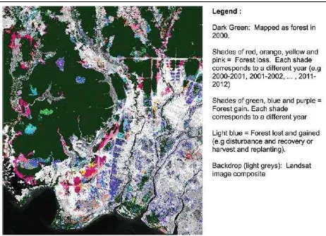
This study aims to analyse the dynamics of land-use and land-cover (LULC) in a selected southern Amazonian area (Brazil), monitoring and distinguishing
Remote sensing is a suitable tool for estimating the spatial variability of crop canopy characteristics, such as canopy chlorophyll content (CCC) and green
