isprs archives XLII 2 W7 1083 2017
Teks penuh
Gambar
Garis besar
Dokumen terkait
Although the NTL data value is saturated and blooming at the edge of urban, which may be overestimate the radiance light value for urban area, the spatially averaged value 0.76 and
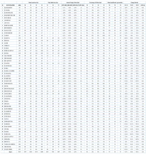
The determination of regional core cities is based on the following indicators: GDP and population in main urban area during the study period (1980 - 2010), the
Forecasted results showed that Chengmai urbanization level would continue to grow in the next five years, and expected to top 50% in 2017. By then, Chengmai will be an urban
Accordingly, this study uses high resolution EO data Pleiades satellite imagery to map and document land cover for the rapidly expanding area of Midrand in Johannesburg, South
To solve the problems of existing method of change detection using fully polarimetric SAR which not takes full advantage of polarimetric information and the
In this paper, an efficiently automatic building rooftop extraction and building change detection approach is shown and accurate results can be achieved based on WorldView-2 stereo
Results demonstrated that TSX and CSK urban DSMs are compatible in open, built-up and forest land forms with the absolute accuracy of 8- 10 m.. The relative accuracies based on
This is the main goal of its4land, an European Commission Horizon 2020 project that aims to develop innovative tools inspired by the continuum of land rights,
