http://www.sciencedirect.com/science?_ob=ArticleURL&_udi=B6V91-4JW7WM5-Practical application of a land resources information system
for agricultural landscape planning
Fabiola Saroinsonga, , , Koji Harashinab, , Hadi Arifinc, , Komarsa Gandasasmitac, and Keiji Sakamotod,
a
Graduate School of Natural Science and Technology, Okayama University, Tsushima 1-1-1, Okayama 700-8530, Japan
b
Faculty of Agriculture, Iwate University, Ueda 3-18-8, Morioka, Iwate 020-8550, Japan c
Faculty of Agriculture, Bogor Agricultural University, Darmaga, Bogor 16680, Indonesia d
Graduate School of Environmental Science, Okayama University, Tsushima 1-1-1, Okayama 700-8530, Japan
Abstract
This paper addresses a multi-criteria analysis approach to agricultural landscape planning. The case study was conducted in the Cianjur watershed, West Java, Indonesia, which has experienced soil erosion problems in recent years. The planning process consists of erosion hazard, land suitability, and economic feasibility analyses. Land resource information was developed as a GIS database from topographic maps, Landsat TM images, soil maps, and climatic data. Using these data, the universal soil loss equation was applied to erosion hazard analysis. In land suitability analysis, the land requirement of plants, and land resources characteristics were compared on the basis of Food and Agriculture Organization's land suitability evaluation methods. Production cost profiles and price data for each crop were used in the economic feasibility analysis. On the basis of the integrated results of the three analyses, proposed agro-ecological land-use was planned under which the land-utilization types would not cause more than tolerable soil loss, would be at least marginally suitable with regard to land resources quality, and would be economically feasible. When compared with current agricultural land-use, the proposed agro-ecological land-use would reduce total soil loss in the area by about 75%, with a reduction in total profit from agricultural production of just 3.1%.
Keywords: Multi-criteria analysis; Erosion hazard; Land suitability; Economic feasibility; Mountainous topography
Article Outline
1. Introduction 2. Study area
2.1. General description of study area
2.2. Land-utilization types definition in this study 3. Materials and methods
3.1. Framework of study scheme
http://www.sciencedirect.com/science?_ob=ArticleURL&_udi=B6V91-4JW7WM5-3.3. Erosion hazard analysis
3.3.1. Estimated soil loss 3.3.2. Tolerable soil loss 3.4. Land suitability analysis 3.5. Economic feasibility analysis 3.6. Planning process model 4. Results
4.1. Erosion hazard analysis 4.2. Land suitability analysis 4.3. Economic feasibility analysis 4.4. Proposed agro-ecological land-use 5. Discussion
5.1. Planning process
5.2. Proposed agro-ecological land-use 6. Conclusion
Acknowledgements References
Vitae
1. Introduction
There is an urgent need in Indonesia for evaluation of agricultural landscapes and associated planning, owing to problems faced in recent years in the form of increasing pressures on agricultural lands from other uses, coupled with increasing demand for agricultural products due to population growth. For example, in 2003, when the population growth rate stood at 1.49% year−1, Indonesia had to provide agricultural products for 3 million people more than in the previous year, in addition to meeting the requirements of the existing population of 210 million. However, at the same time 100,000 ha year−1 of agricultural land was being converted to non-agricultural land (Khrisnamurti, 2003). Moreover, some areas were characterized by inappropriate agricultural land-use, whereas others were experiencing deforestation due to expansion of production fields (Baba et al., 2001). These will lead to both environmental and socio-economic problems, including poverty and unsustainable use of land resources (Webster, 1997, Stevenson and Lee, 2001 and Iwata et al., 2003).
http://www.sciencedirect.com/science?_ob=ArticleURL&_udi=B6V91-4JW7WM5-occurs from the standpoint of a multi-criteria analytical approach seeking the sustainable use of land resources in an agricultural landscape, the objective is to identify land uses that are ecologically friendly, efficient and profitable, are accepted by society, and meet social needs.
Although the multi-criteria analysis approach is essential if sustainability is to be achieved, application of this approach is not simple. Every area has specific characteristics and problems that result in unique demands. As a result, they need specific planning frameworks as well. Some areas may experience declines in biodiversity, whereas others may have social conflict or suffer from poverty. All require the application of a multi-criteria analytical approach in the planning process for sustainable use of land resources, because this approach integrates all the analyses and evaluations of all aspects of the problem, although the priorities and focus will differ in each case. Svoray et al. (2005) applied this approach to address diminishing biodiversity by implementing a multi-criteria analysis that stressed habitat heterogeneity. Previously, Pieterse et al. (2002) had used a similar approach to evaluate the ecological function of wetland ecosystems.
The agricultural landscape planning approach was tested in a practical application in the Cianjur watershed, West Java, Indonesia, with the object of assuring resource use sustainability and addressing current problems. This area was designated a water reservation area by Presidential Decree No. 79 issued in 1985 and No. 48 issued in 1989, and then by Cianjur District Government Regulation No. 1 issued in 1997. It is also one of West Java's important agricultural production centres. Sedimentation in the lower part of the watershed and sharp fluctuation in river water levels in this area have been observed in recent years, indicating that land resource degradation is occurring, especially with regard to soil and water retention functions. It is important that this be addressed, as precipitation is high (average annual rainfall is 3572 mm), and some areas are steep (1149 ha has a slope of 24–45%) or very steep (189 ha has slopes >45%) (Kaswanto et al., 2003 and Saroinsong et al., 2003).
Previous research has been conducted in the same study area in the form of inventory studies and problem analyses under the same research project. For instance, studies have addressed the soil conservation-based decision support system (Pertiwi et al., 2001), topographic conditions and land-use (Harashina and Takeuchi, 2002 and Harashina et al., 2003a), water quality evaluation (Kaswanto et al., 2003), estimation of human-activity-induced nitrogen flows (Harashina et al., 2003b), and economical survival strategy (Mugniesyah and Mizuno, 2001). Making use of the results of these previous studies, a multi-criteria-based planning model and framework that included environmental, economic, and social aspects was developed to support agricultural landscape planning and to propose an agro-ecological land-use plan for the Cianjur watershed. The objective of this paper is to present the process of agricultural landscape planning by a multi-criteria analysis approach, in an environment that has experienced soil erosion problems.
2. Study area
http://www.sciencedirect.com/science?_ob=ArticleURL&_udi=B6V91-4JW7WM5-The Cianjur watershed is located in the central part of West Java, Indonesia (Fig. 1), on the east-facing slope of Mount Gede (2958 m), which is a stratovolcano with a broad footslope formed by a lahar (volcanic debris flow). The Indonesia Soil and Climate Research Centre (Puslitanak) has performed soil observations at 13 units throughout this watershed, as recognized on the soil map of Cianjur watershed. On the basis of data derived from these soil observation units, four present soil orders were identified, namely Inceptisol, Andisol, Ultisol, and Alfisol (Saroinsong et al., 2003); soil nomenclature is based on the U.S. Soil Taxonomy classification system (Soil Survey Staff, 1999). Soil texture ranges from heavy clay to coarse sandy loam. Inceptisol forms alluvium on floodplain, some as well-drained volcanic soil in steep middleland, and some as poorly drained volcanic soil in flat-lowland of the watershed. The Andisol is a well-drained and fertile volcanic soil covering the mountainous areas in the upper part of the watershed. Ultisol accounts for the smallest proportion of the study area (<10%) and is composed of fairly poorly drained, infertile volcanic soil located in the middleland, with a high aluminium content. The area with the shallowest soil depth (62 cm) belongs to Alfisol soil, a moderately drained and highly fertile soil found in the middleland of the watershed.
Full-size image (150K)
Fig. 1. Location of study area: (a) Citarum watershed; (b) Cianjur watershed.
This area is a typical rural volcanic footslope landscape frequently found in Java. Dry fields dominate on the footslope upland, and paddy fields on the lowland. A vast tea plantation is located on the side of Mount Gede, other areas not covered by the plantation are dry fields. Agroforestry is practised in places across the entire area, as mixed garden (Kebun campuran) or forest garden (Talun) land uses. Mixed garden refers to land where perennial crops, mostly trees, are planted, and under which annual crops are cultivated (Karyono, 1990). Forest garden refers to land that is not cultivated or extensively maintained, although it is harvested, usually for wood and firewood. Cianjur City is a major urban centre with a population of 140,000, and is located in the central part of the area. The study area is a typical example of an area subjected to rapid urbanization and land development for resort villas. The latter has occurred because the area is easily accessible from large cities such as Jakarta and Bandung via a highway that runs through the area.
The planning area for this study was bio-physically determined by watershed delineation (van Noordwijk et al., 2001). Total area is 5935 ha with elevations ranging from 275 to 2863 m above sea level.
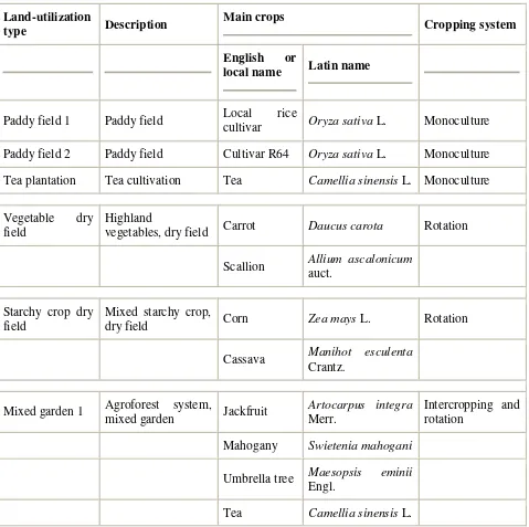
http://www.sciencedirect.com/science?_ob=ArticleURL&_udi=B6V91-4JW7WM5-Land-utilization in the study area varies, in terms of the type of plants used as main crops, the cultivation patterns and land management practices. Eight categories of land-utilization type were developed (for definitions of each utilization-type name, see Table 1). The eight utilization types are the dominant land uses in the study area. The spatial distribution of land-utilization types under the current agricultural land-use is shown in Fig. 2.
Table 1.
Land-utilization-type definitions
Land-utilization
type Description
Main crops
Cropping system
English or
local name Latin name
Paddy field 1 Paddy field Local rice
cultivar Oryza sativa L. Monoculture
Paddy field 2 Paddy field Cultivar R64 Oryza sativa L. Monoculture
Tea plantation Tea cultivation Tea Camellia sinensis L. Monoculture
Vegetable dry field
Highland
vegetables, dry field Carrot Daucus carota Rotation
Scallion Allium ascalonicum auct.
Starchy crop dry field
Mixed starchy crop,
dry field Corn Zea mays L. Rotation
Cassava Manihot esculenta Crantz.
Mixed garden 1 Agroforest system,
mixed garden Jackfruit
Artocarpus integra Merr.
Intercropping and rotation
Mahogany Swietenia mahogani
Umbrella tree Maesopsis eminii Engl.
http://www.sciencedirect.com/science?_ob=ArticleURL&_udi=B6V91-4JW7WM5-Land-utilization
type Description
Main crops
Cropping system
English or
local name Latin name
Broccoli Brassica oleracea var. asparagoides
Banana Musa paradisiaca
L.
Cassava Manihot esculenta Crantz.
Mixed garden 2 Agroforest system,
mixed garden Coconut Cocos nucifera L.
Intercropping and rotation
Mahogany Swietenia mahogani
Rambutan Nephelium lappaceum L.
Bamboo Bambusa spp.
Cassava Manihot esculenta Crantz.
Banana Musa paradisiaca
L.
Forest garden Agroforest system,
forest garden Bamboo Bambusa spp. Intercropping
Umbrella tree Maesopsis eminii Engl.
Mahogany Swietenia mahogani
http://www.sciencedirect.com/science?_ob=ArticleURL&_udi=B6V91-4JW7WM5-Fig. 2. Current agricultural land-use map.
3. Materials and methods
3.1. Framework of study scheme
The study framework emphasized the importance of planning based on an area's specific demand and problem, which in the case of this area is soil and watershed conservation (Fig. 3). The proposed planning process consists of erosion hazard analysis, land suitability analysis, and economic feasibility analysis. The results of these analyses were integrated into the proposed agro-ecological land-use, which was proposed as the final study output. Each land-use in proposed agro-ecological land-use was to be ecologically suitable, economically feasible, and address the existing tendency toward soil erosion and sedimentation.
Full-size image (51K)
Fig. 3. Framework of the study.
3.2. Data source and land resources data developing
http://www.sciencedirect.com/science?_ob=ArticleURL&_udi=B6V91-4JW7WM5-cost and yield, and product price for 2001 were derived from the Agricultural Bureau of Cianjur District Government.
The process for developing the land resources data used in the three analyses mentioned above is briefly described in Fig. 4.
Full-size image (53K)
Fig. 4. Data sources and data extraction and processing for analyses. S1: most suitable, S2: moderately suitable, S3: marginally suitable, LUT: land-utilization type, LS: slope length and steepness factor, Cm: cropping and management factor, Cp: conservation control practice factor, K: soil erodibility factor, R: rainfall-runoff erosivity factor, TSL: tolerable soil loss.
The Salabintana topographic map was input to GIS format by manual digitization and entry of attributes. This map and two other topographic maps already in digital form were merged into one topographic map covering the watershed. This was subsequently used to extract contour and land-use data. A digital elevation model generated from contour data through interpolation was utilized to calculate and classify slope classes, from which a slope steepness map was made.
In the land-use mapping using Landsat TM images covering the watershed, a supervised Maximum Likelihood classification was applied, since previous studies (Liu et al., 2002 and Dean and Smith, 2003) had confirmed that this was the most suitable and powerful classification method. In initial process of classification, land-use data extracted from the topographic map were used for referencing. The classification procedure was performed until it produced a land cover classified image with an overall Landsat classification accuracy of 80%; the accuracy value refers to the degree of correspondence between classification and reality, was tested by ground-truthing and interviews (Liu et al., 2002 and Dean and Smith, 2003). The current agricultural land-use map (Fig. 2), which includes land-utilization-type information, was made by interpreting the land cover classified image, supplemented by ground-truthing and data from interviews.
The digital soil map was constructed by manually digitizing the boundaries over digital images of the soil map and inputting all attributes, such as soil texture and soil depth.
http://www.sciencedirect.com/science?_ob=ArticleURL&_udi=B6V91-4JW7WM5-erosion hazard analysis and (together with temperature and humidity information) were also used in land suitability analysis.
3.3. Erosion hazard analysis
3.3.1. Estimated soil loss
Estimated annual soil loss was computed by using the universal soil loss equation by Wischmeier and Smith (1965, 1978) expressed as:
ESL=R×K×LS×Cm×Cp
where estimated soil loss (ESL) is estimated average annual soil loss (t ha−1 year−1). The parameters used in this equation are as follows:
1. R is a rainfall-runoff erosivity factor (MJ mm ha−1 h−1 year−1). The factor was calculated using rainfall data in digitized climatic map by the equation:
where EI30 is a total storm energy times a maximum 30 min intensity.
2. K is a soil erodibility factor (t ha h ha−1 MJ−1 mm−1). The soil erodibility factor was calculated on the basis of the soil types and their characteristics (such as texture, soil depth, structure, organic matter, and permeability), derived from digitized soil map, by the equation (Hammer, 1981 and Ministry of Forestry, 1998):
K={1.292[2.1M1.14(10−4)(12−a)+(3.258b−2)+2.5(c−3)]}
where M is a percentage of silt and fine sand, a is percentage of organic mineral, b an aggregate class, and c is a permeability class.
3. LS is a slope length and steepness factor (dimensionless), where L is slope length factor and S is slope steepness factor. An equation used by the Indonesia Ministry of Forestry (Ministry of Forestry, 1998) to calculate L was applied:
where X is slope length, which is identified as the distance from the point of origin of the runoff to the point where the slope steepness decreases sufficiently to cause deposition or to the point where runoff enters a well-defined channel. X can be measured using the GIS function on a digital elevation model of the watershed. An equation used by the Indonesia Ministry of Forestry (Ministry of Forestry, 1998) to calculate S was applied:
where s is percentage of slope steepness, which is obtained from digital slope map.
http://www.sciencedirect.com/science?_ob=ArticleURL&_udi=B6V91-4JW7WM5-4. Cm is a cropping and management factor (dimensionless). Cm values obtained from field experiments in Indonesia under different specific land uses are available (Ministry of Forestry, 1998). The values were chosen on the basis of crop type and method of tillage of each land-utilization type.
5. Cp is a conservation (specifically erosion) control practice factor (dimensionless). Similarly to the Cm factor, values for this factor for several kinds of conservation control usually practiced in Indonesia are available (Ministry of Forestry, 1998). The values were selected on the basis of the applied conservation control practices.
Estimated soil loss calculation was under consultation with the Indonesia Soil and Climate Research Centre.
3.3.2. Tolerable soil loss
Tolerable soil loss was also calculated by using Hammer equation (Hammer, 1981):
where TSL is tolerable soil loss (t ha−1), De effective soil depth (cm), Fd soil depth factor, BI soil volume mass (g cm−3), and T is time of use, in this case determined as 100 years. Parameters used in the equation were derived from the soil map.
Estimated soil loss and tolerable soil loss were then compared to analyze the erosion hazard under the current agricultural land-use as an analytical basis for watershed management (Paningbatan, 2001). On the basis of the results of the analysis, the degree of soil loss severity was categorized into four classes: (1) low soil loss, if estimated soil loss is equal to or less than tolerable soil loss; (2) medium soil loss, if estimated soil loss is more than tolerable soil loss and up to 100 t ha−1 year−1; (3) high soil loss, if estimated soil loss is more than 100 and up to 200 t ha−1 year–1; (4) very high soil loss, if estimated soil loss is more than 200 t ha−1 year−1. 3.4. Land suitability analysis
http://www.sciencedirect.com/science?_ob=ArticleURL&_udi=B6V91-4JW7WM5-analyzed. The former were provided by the Ministry of Agriculture, Indonesia, which obtained the data under the Land Resource Evaluation and Planning Project and its complementary studies (Djaenuddin et al., 1994 and Djaenuddin et al., 2000), and the latter were derived from soil and climatic data. The four suitability classes derived from the analysis for each plant were: most suitable, moderately suitable, marginally suitable and not suitable. The data analysis process is briefly shown in schematic form in Fig. 5.
Full-size image (27K)
Fig. 5. Land suitability analysis scheme.
3.5. Economic feasibility analysis
Economic feasibility of land-utilization type in this study was evaluated from its cost– benefit ratio, which was calculated as:
where R is revenue which is calculated as production (kg) × price (Rp kg−1), C cost (Rp), and Rp is Indonesian rupiah.
The cost–benefit ratio is thus a function of the total crop production, price and cost. Cost refers to all cash outputs (for seed, fertilizer, pesticides and herbicides, and land rent value), and labour (for breeding, field preparation, planting, fertilizing, pesticide and herbicide application, and other maintenance practices, such as watering or weeding, until harvest occurs). If the value of the cost–benefit ratio exceeds one, it is assumed that the land-utilization type will provide a good return, with benefits exceeding costs (Miranda, 2001). In addition, the benefit itself is also compared; the higher the benefit, the more preferred the land-utilization type. The results of this analysis were used to compare and select land-utilization type, and to evaluate the effectiveness of costs they have and how much money farmers could earn to support their daily lives.
http://www.sciencedirect.com/science?_ob=ArticleURL&_udi=B6V91-4JW7WM5-conversion of land-utilization types, the land suitability classes for proposed agro-ecological land-use, on average, may be different from those for current agricultural land-use. The use of different land suitability classes would thus result in differences in yield: use of more suitable land-utilization types would increase the yield (Food and Agriculture Organization, 1993 and Tomar et al., 1996). The disadvantage, then, is that estimates of the benefits of the proposed agro-ecological land-use may be affected.
3.6. Planning process model
The planning process model was composed of three analyses and utilized a step-by-step approach to select the appropriate land-utilization types and to plan the proposed agro-ecological land-use (Fig. 6). Three analyses were ordered, on the basis of their importance relative to problem-solving in the study area. Prevention of soil loss is the most important problem to solve in this case. The use of land management practices that are suitable for watershed land resources thus preventing watershed function degradation is the secondary aim. Thus, the planning model is a sequential decision-making process that begins with erosion hazard analysis as the first filter, followed by land suitability analysis and then economic feasibility analysis. Erosion hazard is a crucial filter, because erosion factors (with the exception of cropping and management factors and conservation control practice factors) are uncontrollable variables under most conditions.
Full-size image (47K)
Fig. 6. Planning process model. LUT: land-utilization type, ESL: estimated soil loss, TSL: tolerable soil loss, S1: most suitable, S2: moderately suitable, S3: marginally suitable, NS: not suitable, B/C: cost–benefit ratio.
http://www.sciencedirect.com/science?_ob=ArticleURL&_udi=B6V91-4JW7WM5-evaluated to replace the current one. Several land-utilization types might pass the erosion hazard analysis and then be subject to land suitability analysis. If a land-utilization type were categorized as not suitable, the procedure was to search for a new potential land-utilization type. If several alternative land-utilization types were suitable (most suitable, moderately suitable or marginally suitable) for the same land unit, the more suitable land-utilization type was selected for subsequent economic feasibility analysis. In brief, the most suitable land-utilization type was preferred over the moderately suitable one, and so on. Only those land-utilization types that fulfilled the requirement of benefits outweighing costs were compared according to the benefits they offered. The most favourable land-utilization types from the standpoint of economic feasibility were those with the highest benefits. If the analysis revealed that the land-utilization types that were suitable from the standpoint of land characteristics did not have good benefit profiles, alternatives land-utilization types that had the same or lower suitability classification were considered (as long as the suitability class ≠ not suitable). If no alternatives were found, the process began anew. Only land-utilization types that passed the three analyses were proposed as better alternative land-utilization types in proposed agro-ecological land-use. After the three analyses, proposed agro-ecological land-use was supplemented by consideration of social aspects and constraints, or the current state of the agricultural infrastructure, as appropriate.
http://www.sciencedirect.com/science?_ob=ArticleURL&_udi=B6V91-4JW7WM5-Because the focus was on agricultural use planning, it was assumed that land-utilization types of the preservation forest and settlement area were static.
4. Results
4.1. Erosion hazard analysis
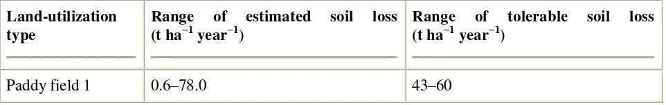
Comparison between estimated soil loss and tolerable soil loss generated an erosion hazard map of the Cianjur watershed, based on current agricultural land-use (Fig. 7), that identified the erosion hazard area where intolerable soil loss was predicted. This area was grouped into four classes that indicated how urgently management was needed. Estimated soil loss for the watershed under current agricultural land-use ranged from 0 (in flat forest areas) to 344 t ha−1 year−1 (in very steep areas of Vegetable dry fields); tolerable soil loss ranged from 25 to 60 t ha−1 year−1. Although no significant erosion (estimated soil loss < tolerable soil loss) was predicted in 4416 ha (74%) of the watershed area, estimated soil loss was predicted to exceed tolerable soil loss on 1219 ha (26% of the watershed area); in some areas (covering 466 ha, mostly utilized as Vegetable dry field) estimated soil loss was very high (>200 t ha−1 year−1). The relationship between land-utilization type and estimated soil loss in current agricultural land-use is summarized in Table 2, particularly for current agricultural land-use. The results indicate that practiced Vegetable dry field and Starchy crop dry field urgently required better land management practices in terms of cropping and management factor and conservation control practice factor.
Full-size image (38K)
Fig. 7. Erosion hazard map. ESL: estimated soil loss and TSL: tolerable soil loss.
Table 2.
Relationship between land-utilization type, estimated soil loss and tolerable soil loss in current agricultural land-use
Land-utilization type
Range of estimated soil loss (t ha−1 year−1)
Range of tolerable soil loss (t ha−1 year−1)
http://www.sciencedirect.com/science?_ob=ArticleURL&_udi=B6V91-4JW7WM5-Land-utilization type
Range of estimated soil loss (t ha−1 year−1)
Range of tolerable soil loss (t ha−1 year−1)
Paddy field 2 0.5–26.1 36–50
Tea plantation 4.9–167.3 35–45
Vegetable dry field 12.8–344.2 25–50
Starchy crop dry
field 12.8–341.9 35–50
Mixed garden 1 4.1–184.7 25–40
Mixed garden 2 3.9–164.9 35–43
Forest garden 0.1–85.5 25–38
In cases where the current land-utilization type caused significant soil loss, land management practice improvements and land-utilization-type conversions were considered that could reduce soil loss. The following measures are listed in order, starting with the most preferred measure, according to the convenience of application: (1) alteration of the cropping and management factor through adoption of a minimum tillage system. (2) Alteration of the conservation control practice factor through better conservation control practices. For instance, an irregular strip planting system should be changed to a contour planting (strip planting across the slope) and hedgerow system. (3) Land-utilization-type conversion or alteration of the slope length and steepness factor by terracing; both of these last two options are last choices, considering the high investment and potential social constraints.
4.2. Land suitability analysis
http://www.sciencedirect.com/science?_ob=ArticleURL&_udi=B6V91-4JW7WM5-dry field plants. Slope steepness was a limiting factor, however, so improvements in land management practices are essential.
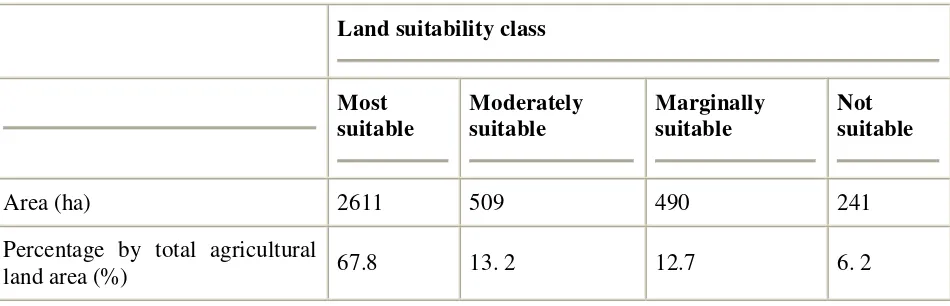
Table 3.
Areas of land suitability classes under current agricultural land-use
Land suitability class
Most suitable
Moderately suitable
Marginally suitable
Not suitable
Area (ha) 2611 509 490 241
Percentage by total agricultural
land area (%) 67.8 13. 2 12.7 6. 2
On the basis of this analysis, the existing land-utilization types that are suitable, the more suitable the better, were selected from the options of land-utilization type that have passed erosion hazard analysis for the subsequent economic feasibility analysis.
4.3. Economic feasibility analysis
All land-utilization types that passed the erosion hazard and land suitability criteria had a cost–benefit ratio >1, although the profits realised varied. Among the alternative potential land-utilization types for given areas, the land-land-utilization type with the best benefit was preferred (Table 4). For example, Paddy field 1 was harvested only twice each year but had a higher cost– benefit ratio than Paddy field 2 which was harvested three times a year, because of its higher price. Vegetable dry field also had a high crop price, but the highly intensive management resulted in a large production cost, which reduced the cost–benefit ratio, even though the benefit was still high overall. Tea plantation areas were in a production period with low cost requirements and a resultant high cost–benefit ratio. Mixed garden 1, Mixed garden 2, and Forest garden were lower in benefit and showed a slow initial return, although total cost was also lower.
Table 4.
http://www.sciencedirect.com/science?_ob=ArticleURL&_udi=B6V91-4JW7WM5- Land-utilization type
Cost
(Rpa ha−1 year−1)
Revenue
(production × price) (Rp ha−1 y−1)
Benefit (Rp ha−1 y−1)
Cost– benefit ratio
Paddy field 1 6174000 21600000 15426000 2.5
Paddy field 2 6809400 15000000 8190600 1.2
Tea plantation 12446000 95601900 83155900 6.7
Vegetable dry
field 29750000 61608500 31858500 1.1
Starchy crop
dry field 7395900 20400000 13004100 1.8
Mixed garden
1 3125400 8027350 4901950 1.7
Mixed garden
2 2311800 8172000 5860200 2.5
Forest garden 738000 2799000 2061000 2.8
a
Indonesian rupiah (US$ 1 = Rp 9500 at time of study).
4.4. Proposed agro-ecological land-use
On the basis of the results of the three analyses, agro-ecological land-use was proposed that is suitable and feasible for the Cianjur watershed, with tolerable erosion impacts (Fig. 8). The land-utilization types in the proposed agro-ecological land-use did not differ from the current agricultural land-use; the difference is only in spatial distribution and area. The proposed agro-ecological land-use consists of eight land-utilization-type groups (Table 5), as follows.
http://www.sciencedirect.com/science?_ob=ArticleURL&_udi=B6V91-4JW7WM5-(2) Tea plantation (403 ha). It was proposed that 48 ha (10.8%) of the current Tea plantation area be converted into Mixed garden 2 because of the intolerable soil loss that might occur under this land-utilization type. No expansion of the plantation was proposed, even if only to substitute for the lost area. The main reason for this is that only limited land was suitable for this land-utilization type. It was noted that the cost–benefit ratio of a new plantation in the short term would be much lower than that of a plantation in the production stage. The other reason was related to specific land tenure and management requirements. The areas suitable for tea, apart from the existing plantation, belong to individual farmers and not to the corporation that owns the existing plantation. Tea requires particular management after harvesting, and the product is sold through a specific trade chain. These factors make conversion of land to tea growing unfavorable for individual farmers, as they do not want to feel bounded by authority.
(3) Vegetable dry field (280 ha). The factor limiting expansion of this land-utilization type was the steep slopes usually found in the upland areas, as Vegetable dry field might cause severe soil erosion in steep areas with heavy rainfall. For this reason, in spite of good profits, some areas currently under Vegetable dry field were converted to Mixed garden 1 and Mixed garden 2 in the proposed agro-ecological land-use. The other existing areas could be continued as Vegetable dry field, but with improved land management practices, such as terracing and barrier hedging.
(4) Starchy crop dry field (280 ha). In order to reduce soil erosion, 66 ha now in Starchy crop dry field where severe erosion was predicted were converted to Mixed garden 2 in the proposed plan.
(5) Mixed garden 1, Mixed garden 2, and Forest garden (914 ha). These land-utilization types should be applied in areas where the erosion hazard is high and careful land management practices are needed. The proposed agro-ecological land-use suggests that these land-utilization types be applied in some parts of Gede Pangrango Mount, Puntang Hill (Fig. 1 and Fig. 8), and steep areas along rivers located on volcanic slopes.
Full-size image (54K)
Fig. 8. Proposed agro-ecological land-use map.
Table 5.
http://www.sciencedirect.com/science?_ob=ArticleURL&_udi=B6V91-4JW7WM5-cropping and management factor and conservation control practice factor].
On the whole, a total of 488 ha (12.7%) was proposed for conversion to other land-utilization types, and 923 ha (24% of total agricultural land) was kept in the same land-land-utilization type, but with changes in terms of cropping management and conservation control practices. Possible improvements included conversion of the strip planting system to contour line, minimum tillage, and hedgerow systems (Agus et al., 1997 and Crasswell et al., 1997).
Comparison between current agricultural land-use and proposed agro-ecological land-use is summarized in Table 5. The proposed agro-ecological land-use would reduce the area's total soil loss by about 75%, and the current maximum erosion of 344 t ha−1 year−1 would become 60 t ha−1 year−1. In terms of land suitability, the proposed agro-ecological land-use is also expected to eliminate the not suitable-class land-utilization type, which currently covers 6.2% of the total agricultural land, and to increase the most suitable and moderately suitable-class land-utilization type. However, the total benefit from agricultural production would decrease by 3.1% (Table 6).
Table 6.
General comparison between current agricultural land-use and proposed agro-ecological land-use
land-
http://www.sciencedirect.com/science?_ob=ArticleURL&_udi=B6V91-4JW7WM5-Current agricultural land-use
Proposed agro-ecological land-use
Average (t ha−1 year−1) 205 50.8
Maximum (t ha−1 year−1) 344 60
Land suitability (%)
S1 67.8 69.4
S2 13.2 19.2
S3 12.7 11.4
NS 6. 2 0
Benefit
Total (million year−1) Rpa 88906 Rp 86144
Average
(million ha−1 year−1) Rp 23 Rp 22
S1: most suitable, S2: moderately suitable, S3: marginally suitable, NS: not suitable.
a
Indonesian rupiah (US$ 1 = Rp 9500 at time of study).
5. Discussion
5.1. Planning process
http://www.sciencedirect.com/science?_ob=ArticleURL&_udi=B6V91-4JW7WM5-criteria. Its application in this study thus eliminated the risk that a land-utilization type that clearly might have caused erosion to a certain land unit might have become an option along with the safe ones. The planning process still flexibly evaluated various alternatives and provided the chance to have profitable utilization types, but it did not compromise on erosion-risky land-utilization types, or, later, on unsuitable land characteristics. Meanwhile, by using a pairwise comparison method and a rating method, scores for all criteria are assigned quantitatively and qualitatively, respectively, so that the more important criterion is weighted more heavily than the less important one (Center for International Forestry Research, 1999 and Phua and Minowa, 2005). However, for example from the standpoint of this case, there is still a chance that a risky land-utilization type could be perceived in a similar way to one that may not cause erosion. It is even possible that the risky land-utilization type could be chosen if it had high scores for land suitability and cost–benefit analysis because the total of each weighting multiplied by the score was high.
The contribution of data availability to selection of the evaluation method is outlined below. Process-based models such as the water erosion prediction project (WEPP) model, the European soil erosion (EUROSEM) model, and the Griffith University Erosion System Template (GUEST) model are now still much less efficient than empirical models with local parameters (Fistikoglu and Harmancioglu, 2002 and Verbist et al., 2002). Because little satisfactory validation is available, these models were not considered further for application to the study. Empirical models give more options, because they provide simple equations and broadly documented derivation of the factors required. The universal soil loss equation (USLE) (Wischmeier and Smith, 1965, 1978), revised USLE (RUSLE) (Renard et al., 1997), modified USLE (MUSLE) (William, 1975) and Morgan, Morgan and Finney (MMF) model (Morgan et al., 1984) are examples of such empirical models used to calculate soil loss. However, weaknesses in their application have also been reported. At a large scale, the accuracy of USLE, MMF, and WEPP decreases rapidly and the absolute soil loss cannot be obtained with a sufficient degree of confidence (Verbist et al., 2002 and Amore et al., 2004). Moreover, USLE, RUSLE, and MUSLE do not account for gully and channel erosion. USLE cannot deal with deposition, which is not the case for RUSLE and MUSLE. Use of RUSLE in West Java, as conducted by van Dijk et al. (2002), where our study area is located, resulted in unrealistic soil erosion estimation.
http://www.sciencedirect.com/science?_ob=ArticleURL&_udi=B6V91-4JW7WM5-Stakeholder involvement before final decision-making is very valuable for generating decision support for implementation, as it provides insights into social values and constraints (Center for International Forestry Research, 1999). However, reacting only to local decisions in agricultural landscape management may have no underlying ecological advantage and involvement itself does not mean total accommodation of stakeholders’ wishes. Besides, stakeholders’ opinions may change and improve through learning and understanding during the planning process (Center for International Forestry Research, 1999, Stevenson and Lee, 2001, Thomas, 2002 and Gunawan et al., 2003). The planning model development and planning process involves interactions and understanding among stakeholders. It is a learning process both for scientific groups, including proposed agro-ecological land-use planners, and for stakeholders (Gunawan et al., 2003 and Mizuno and Mugniesyah, 2003). Participation is accommodated in the proposed agro-ecological land-use on the condition that there is improved understanding and improved acknowledgment of stakeholders.
Application of such a planning process to other areas that are under threat or subject to watershed function degradation, especially by soil erosion, is easily implemented because of the similarity of criteria and the relative importance of each criterion. Conversely, planning for areas with different problems or plan objectives requires adjustments. For example, in areas facing biodiversity threats, criteria may need to be changed to find ones suitable for use in environmental impact analysis. In other cases, filters may need to be rearranged and different filtering sequences used. For example, in areas that lack environmental problems but where poverty is an issue, the analysis should include a greater focus on socioeconomic factors, and socio-economic analysis would need to be placed first.
5.2. Proposed agro-ecological land-use
The current agricultural development policy for the Cianjur District, as in other regions in Indonesia, tends to be strongly based on government administrative area – for example by sub-district or village – rather than on delineation by ecological characteristics. Even though such administrative-area-based plans are easy to generate, unfortunately they are generalized and carry risks in terms of land resource use and management faults (van Noordwijk et al., 2001 and Stevenson and Lee, 2001). The plan for the proposed agro-ecological land-use helps local government, as the management authority, to make agricultural development policies that are more environmentally and socioeconomically oriented.
http://www.sciencedirect.com/science?_ob=ArticleURL&_udi=B6V91-4JW7WM5-management factors and in conservation control practice factors (without land-utilization-type change) contributed 43% of the total soil loss reduction. This result indicates the importance of improvements in land management practices (in this case, particularly by means of agronomic practices that are useful in erosion control) under the same land-use, as well as of land-use conversion.
The land-use conversion and land-management practice improvements suggested in the proposed agro-ecological land-use could not be easily implemented in reality because of socioeconomic constraints. Convincing farmers to change the land-utilization type or to improve land management practices on their land is difficult, because of increased costs or reduced income. However, the results of this study indicate the potential for greatly reducing soil loss while reducing economic benefits by only 3%; this is assumed to be the opportunity cost of the proposed agro-ecological land-use. Moreover, this benefit reduction is misleading, because the revenue in the proposed agro-ecological land-use does not assess the change in production – most likely an increase – caused by the improved land suitability. Incentives or subsidies by local government may be alternatives that would support implementation of the proposed agro-ecological land-use. The strategies and management activities based on the plan should also be discussed and elaborated by local inhabitants, government, and other stakeholders before being implemented (Marsh, 1997, Franco et al., 2001 and Stevenson and Lee, 2001).
6. Conclusion
The planning model is assertive in sieving a set of alternatives by its filtering and selection process, but it still accommodates both the most important interests and less important ones. It avoids complexity in setting priorities and helps to focus on the most important objective. When planning under conditions of urgency as a result of a threat, or when there is a distinct order of importance in the planning objectives, this approach is suggested as helpful and efficient. However, essential requirements must be met before the model is applied: the sequence of priorities must be made clear and the model must respond effectively to the problem.
Although this planning model adopted a multi-criteria analysis approach, the variables used are simple and utilize commonly available data. For a more comprehensive framework or a more detailed plan (e.g., on a farm scale), the model in this study should be enhanced by adding more variables to the analysis.
http://www.sciencedirect.com/science?_ob=ArticleURL&_udi=B6V91-4JW7WM5-to integrate the evaluation methods with GIS, enabling the multi-criteria analysis http://www.sciencedirect.com/science?_ob=ArticleURL&_udi=B6V91-4JW7WM5-to work simultaneously on all land units in the watershed.
In the planning of the proposed agro-ecological land-use for the watershed, improvement of land resource management practices under the same land-use was revealed to have good potential in helping to overcome soil erosion problems, as did land-use conversion.
Because it was based on the specific characteristics and problems of the Cianjur watershed, this planning model should not be instantly applied to other areas, but should first be adjusted to meet local issues and needs. In a situation where the problem or objective is different, there is need to change or input more criteria or re-arrange the filtering sequence.
The products of this study, including the land resources-based map, erosion hazard map, and the proposed agro-ecological land-use, could be used to compose agricultural development strategies. The classification of areas experiencing erosion into three classes – moderate soil loss, high soil loss, and very high soil loss – is intended to provide information more clearly to both farmers and government. Surely all classes except the ―no erosion‖ class require similar, precise action. However, these actions seem difficult to implement simultaneously. Obtaining detailed information about the distribution of areas that are experiencing low soil loss, those that are experiencing medium soil loss, and those that are experiencing high soil loss helps government to set up proper strategies in accordance with the urgency of the management that needs to be implemented.
This study has clarified the application of the multi-criteria analysis approach to land-use planning. It provides options for agricultural landscape planning in environments that are experiencing soil erosion problems.
Acknowledgements
This study was partly funded by the Core University Program in Applied Biosciences, promoted by the Japan Society for the Promotion of Science and the Directorate General of Higher Education, Indonesian Ministry of Education and Culture. The study was also partly funded by the Toyota Astra Foundation. We express our gratitude to Mr. Bambang Trisasongko, Cartography and Remote Sensing Laboratory, Bogor Agricultural University, who supported the GIS analysis for this study.
References
Agus et al., 1997 F. Agus, D.K. Cassel and D.P. Garrity, Soil-water and soil physical properties under contour hedgerow systems on sloping oxisols, Soil Tillage Res. 40 (1997), pp. 185–199.
http://www.sciencedirect.com/science?_ob=ArticleURL&_udi=B6V91-4JW7WM5-Amore et al., 2004 E. http://www.sciencedirect.com/science?_ob=ArticleURL&_udi=B6V91-4JW7WM5-Amore, C. Modica, M.A. Nearing and V.C. Santoro, Scale effect in USLE and WEPP application for soil erosion computation from three Sicilian basins, J. Hydrol. 293 (2004), pp. 100–114. Article | PDF (501 K) | View Record in Scopus | Cited By in Scopus (18)
Antoine et al., 2000 J. Antoine, F.I. Dent, D. Sims and R. Brinkmen, Agro-ecological zones and resource management domains (RMDs) in relation to land-use planning. In: B. Euro and P. Nijkamp, Editors, Multicriteria Analysis for Land-Use Management, Kluwer Academic Publishers, London (2000), pp. 311–331.
Baba et al., 2001 A. Baba, S. Tsuyuki and L.B. Prasetyo, Land-use/cover change detection caused by development using satellite RS data—the case study of Danau River Watershed, Indonesia. In: Y. Hayashi and K. Takeuchi, Editors, Proceedings of the 1st Seminar Toward Harmonisation between Development and Environmental Conservation in Biological Production Tokyo (2001), pp. 207–214.
Center for International Forestry Research, 1999 Center for International Forestry Research, Guidelines for Applying Multi-Criteria Analysis to the Assessment of Criteria and Indicators, Center for International Forestry Research, Jakarta (1999).
Crasswell et al., 1997 E.T. Crasswell, A. Sajjapongse, D.J.B. Hawlett and A.J. Dowling, Agroforestry in the management of sloping lands in Asia and the Pacific, Agroforestry Syst. 38 (1997) (3), pp. 121–130.
Dean and Smith, 2003 A.M. Dean and G.M. Smith, An evaluation of per-parcel land cover mapping using maximum likelihood class probabilities, Int. J. Remote Sens. 24 (2003) (14), pp. 2905–2920. Full Text via CrossRef | View Record in Scopus | Cited By in Scopus (18)
Djaenuddin et al., 1994 D. Djaenuddin, H. Marwan, H. Subagyo, A. Mulyani and N. Suharta, Land Suitability for Agriculture and Forestry Plants, Centre of Soil Research, Bogor (1994) (in Indonesian).
Fistikoglu and Harmancioglu, 2002 O. Fistikoglu and N.B. Harmancioglu, Integration of GIS with USLE in assessment of soil erosion, Water Resour. Manage.16 (2002), pp. 447–467. Full Text via CrossRef | View Record in Scopus | Cited By in Scopus (19)
Food and Agriculture Organization, 1993 Food and Agriculture Organization, Guidelines for Land-Use Planning, Food and Agriculture Organization of the United Nations, Rome (1993). Franco et al., 2001 D. Franco, D. Franco, I. Mannino and G. Zannetto, The agroforestry network role in the landscape socioeconomic processes: the potentiality and limits of contingent valuation method, Landscape Urban Plan.4 (2001) (55), pp. 239–256. Article | PDF (449 K) | View Record in Scopus | Cited By in Scopus (3)
http://www.sciencedirect.com/science?_ob=ArticleURL&_udi=B6V91-4JW7WM5-Hammer, 1981 http://www.sciencedirect.com/science?_ob=ArticleURL&_udi=B6V91-4JW7WM5-Hammer, W.I., 1981. Second soil conservation consultant report AGOF/INS/78/006. Tech. Note No. 10, Centre of Soil Research, Bogor.
Harashina and Takeuchi, 2002 K. Harashina and K. Takeuchi, Topographic condition and land use in the rural landscape of West Java, Indonesia, Trans. Rural Plan.4 (2002), pp. 229–234 (in Japanese with English summary).
Harashina et al., 2003a K. Harashina, K. Takeuchi and H.S. Arifin, Toward restructuring for sustainable regional ecosystems in the humid tropics. In: Y. Hayashi, S. Manuwoto and S. Hartono, Editors, Sustainable Agriculture in Rural Indonesia, Gadjah Mada University Press, Jogjakarta (2003), pp. 369–390.
Harashina et al., 2003b K. Harashina, K. Takeuchi, A. Tsunekawa and H.S. Arifin, Nitrogen flows due to human activities in the Cianjur–Cisokan watershed area in the middle Citarum drainage basin, West Java, Indonesia: a case study at hamlet scale, Agric. Ecosyst. Environ.100 (2003), pp. 75–90. Article | PDF (269 K) | View Record in Scopus | Cited By in Scopus (4) Iwata et al., 2003 T. Iwata, S. Nakano and M. Inoue, Impacts of past riparian deforestation on stream communities in a tropical rain forest in Borneo, Ecol. Appl. 13 (2003) (2), pp. 461–473.
Full Text via CrossRef | View Record in Scopus | Cited By in Scopus (24)
Jain et al., 2001 S.K. Jain, S. Kumar and J. Varghese, Estimation of soil erosion for a Himalayan watershed using GIS technique, Water Resour. Manage. 15 (2001), pp. 41–54. Full Text via CrossRef | View Record in Scopus | Cited By in Scopus (15)
Karyono, 1990 Karyono, Home gardens in Java: their structure and function. In: K. Landauer and M. Brazil, Editors, Tropical Home Gardens, The United Nations University Press, Tokyo (1990), pp. 138–146.
Kaswanto et al., 2003 Kaswanto, H.S. Arifin, A. Munandar and K. Iiyama, Sustainable water management in the rural landscape of Cianjur Watershed, West Java, Indonesia. In: Y. Hayashi and K. Takeuchi, Editors, Proceedings of the 2nd Seminar Toward Harmonisation between Development and Environmental Conservation in Biological Production Tokyo (2003), pp. 448– 458.
Khrisnamurti, 2003 B. Khrisnamurti, Food diversification: 40 years experience and future challenge, Soc. Econ. J.2 (2003) (7), pp. 21–26 (in Indonesian).
Liu et al., 2002 X.H. Liu, A.K. Skidmore and V.H. Oosten, Integration of classification methods for improvement of land-cover map accuracy, ISPRS J. Photogram. Remote Sens.56 (2002), pp. 257–268. Abstract | Article | PDF (347 K) | View Record in Scopus | Cited By in Scopus (29) Marsh, 1997 J.S. Marsh, The policy approach to sustainable farming systems in EU, Agric. Ecosyst. Environ. 64 (1997) (2), pp. 103–114. Article | PDF (1057 K) | View Record in Scopus | Cited By in Scopus (9)
Ministry of Forestry, 1998 Ministry of Forestry, Guidelines for Soil Rehabilitation and Conservation Planning in Watershed, Indonesia Ministry of Forestry, Jakarta (1998) (in Indonesian).
Miranda, 2001 J.I. Miranda, Multicriteria analysis applied to the sustainable agriculture problem, Int. J. Sustain. Dev. World Ecol. 8 (2001), pp. 67–77. View Record in Scopus | Cited By in Scopus (7)
http://www.sciencedirect.com/science?_ob=ArticleURL&_udi=B6V91-4JW7WM5-Morgan et al., 1984 R.P.C. http://www.sciencedirect.com/science?_ob=ArticleURL&_udi=B6V91-4JW7WM5-Morgan, D.D.V. http://www.sciencedirect.com/science?_ob=ArticleURL&_udi=B6V91-4JW7WM5-Morgan and H.J. Finney, A predictive model for the assessment of erosion risk, J. Agric. Eng. Res. 30 (1984), pp. 245–253. Abstract | PDF (521 K) | View Record in Scopus | Cited By in Scopus (47)
Mugniesyah and Mizuno, 2001 S.S.M. Mugniesyah and K. Mizuno, Gender, poverty and peasant household survival strategies—a case study in dry land village in West Java. In: Y. Hayashi and K. Takeuchi, Editors, Proceedings of the 1st Seminar Toward Harmonisation between Development and Environmental Conservation in Biological Production Tokyo (2001), pp. 63– 69. Development of a decision support system for management of conservation upland farming. In: Y. Hayashi and K. Takeuchi, Editors, Proceedings of the 1st Seminar Toward Harmonisation between Development and Environmental Conservation in Biological Production Tokyo (2001), pp. 215–221.
Pieterse et al., 2002 N.M. Pieterse, A.W.M. Verkroost, M. Wassen, H.O. Venterink and C. Kwakernaak, A decision support system for restoration planning of stream valley ecosystems, Landscape Ecol. 17 (2002) (1), pp. 69–81. Full Text via CrossRef | View Record in Scopus | Cited By in Scopus (12)
Phua and Minowa, 2005 M. Phua and M. Minowa, A GIS-based multi-criteria decision making approach to forest conservation planning at a landscape scale: a case study in the Kinabalu Area, Sabah, Malays. Landscape Urban Plan. 71 (2005), pp. 207–222. Article | PDF (572 K) | View Record in Scopus | Cited By in Scopus (25)
Renard et al., 1997 K.G. Renard, G.R. Foster, G.A. Weesies, D.K. Mc Cool and D.C. Yoder, Predicting soil erosion by water. A guide to conservation planning with the revised USLE, USDA Hand Book No. 703, USDA, Washington, DC (1997).
Saroinsong et al., 2003 F.B. Saroinsong, H.S. Arifin, K. Gandasasmita and K. Takeuchi, Agro-ecological land allocation for sustainable agriculture land use. In: Y. Hayashi and K. Takeuchi, Editors, Proceedings of the 2nd Seminar Toward Harmonisation between Development and Environmental Conservation in Biological Production Tokyo (2003), pp. 417–425.
Soil Survey Staff, 1999 Soil Survey Staff, Soil Taxonomy: A Basic System of Soil Classification for Making and Interpreting Soil Survey (second ed.), USDA, Washington, DC (1999).
Stevenson and Lee, 2001 M. Stevenson and H. Lee, Indicators of sustainability as a tool in agricultural development: partitioning scientific and participatory processes, Int. J. Sustain. Dev. World Ecol.8 (2001), pp. 57–65. View Record in Scopus | Cited By in Scopus (8)
Svoray et al., 2005 T. Svoray, P. Bar and T. Bannet, Urban land-use allocation in a Mediterranean ecotone: Habitat Heterogeneity Model incorporated in a GIS using a multi-criteria mechanism, Landscape Urban Plan. 72 (2005), pp. 337–351. Article | PDF (918 K) | View Record in Scopus | Cited By in Scopus (15)
http://www.sciencedirect.com/science?_ob=ArticleURL&_udi=B6V91-4JW7WM5-Tomar et al., 1996 S.S. http://www.sciencedirect.com/science?_ob=ArticleURL&_udi=B6V91-4JW7WM5-Tomar, G.P. Tembe, S.K. Sharma and V.S. http://www.sciencedirect.com/science?_ob=ArticleURL&_udi=B6V91-4JW7WM5-Tomar, Studies on some land management practices for increasing agricultural production in Vertisols of Central India, Agric. Water Manage. 30 (1996), pp. 91–106. Article | PDF (1110 K) | View Record in Scopus | Cited By in Scopus (4)
van Dijk et al., 2002 A.I.J.M. van Dijk, A.G.C.A. Meesters, J. Schellekens and L.A. Bruijnzeel, A two-parameter exponential rainfall depth-intensity distribution applied to runoff and erosion modelling, J. Hydrol.300 (2002), pp. 155–171.
van Noordwijk et al., 2001 van Noordwijk, M., Susswein, P.M., Palm, C., Izac, A., Tomich, T.R., 2001. Problem Definition for Integrated Natural Resource Managements in Forest Margin of the Humid Tropics: Characterisation and Diagnosis of Land-Use Practices—Lecture Note 1. ICRAFT South Asia, Bogor.
Verbist et al., 2002 B.J.P. Verbist, M. Noordwijk van, A.C. Tameling, K.C.L. Schmitz and S.B.L. Ranieri, A negotiation support tool for assessment of land-use change impacts on erosion in a previously forested watershed in Lampung, Sumatra, Indonesia. In: A.E. Rizzoli and A.J. Jakeman, Editors, IADS, Proceeding of the 1st Biennial Meeting of IEMSS, vol. 1 Bogor (2002), pp. 9–14.
Webster, 1997 J.P.G. Webster, Assessing the economic consequences of sustainability in agriculture, Agric. Ecosyst. Environ.64 (1997) (2), pp. 95–102. Article | PDF (688 K) | View Record in Scopus | Cited By in Scopus (15)
William, 1975 J.R. William, Sediment yield prediction with USLE using runoff energy factor, In Present and Prospective Technology for Predicting Sediment Yields and Sources. ARS-S-40, USDA, Washington, DC (1975).
Wischmeier and Smith, 1965 W.H. Wischmeier and D.D. Smith, Predicting Rainfall-Erosion Losses from Cropland East of the Rocky Mountains: U.S. Department of Agric. Handbook 282, U.S. Government Printing Office, Washington, DC (1965).
Corresponding author. Tel.: +80 86 251 8375; fax: +80 86 251 8388.
Vitae
Fabiola Baby Saroinsong is a lecturer at Sam Ratulangi University, Indonesia. She holds an MSc in landscape architecture from Bogor Agricultural University, Indonesia, in 2003. Her research interest is in landscape evaluation and planning, including integrating ecological science into evaluation and planning, land-use analysis, and using GIS. At Okayama University, Japan, she is currently working on her PhD in resource management and environmental science.
Koji Harashina is a lecturer at Department of Environmental Sciences, Faculty of Agriculture, Iwate University, Japan. He received his PhD (landscape ecology & local resource management, 2003) and MS (landscape ecology, 1999) at the University of Tokyo. His research has focused on material flow and local resource management in rural landscape. From landscape ecological viewpoint, he has broad interest in restructuring of regional ecosystems and developing recycling society based on local bio-resources.
http://www.sciencedirect.com/science?_ob=ArticleURL&_udi=B6V91-4JW7WM5-University, Indonesia. He got his PhD in 1998 at Okayama http://www.sciencedirect.com/science?_ob=ArticleURL&_udi=B6V91-4JW7WM5-University, Japan, and postgraduate of rural & landscape ecology in 1991 at the International Institute for Geo-lnformation Science & Earth Observation (ITC), the Netherlands. The focus of his research is watershed based in landscape ecological study of the harmonization between rural and urban development.
Komarsa Gandasasmita is a lecturer at Cartography and Remote Sensing Laboratory, Department of Soil Science, Faculty of Agriculture, Bogor Agricultural University, Indonesia. He received his PhD (land use, 2001) at Bogor Agricultural University and MS (applied geomorphology, 1987) at International Training Centre Enchede Netherlands. His research has focused on land use and land suitability, and including cartography and remote sensing works.