URBAN SPACE MORPHOLOGY AND TYPOLOGY
OF THE CITY OF SOLO IN THE EARLY PERIOD (1500-1750)
Qomarun1, Ikaputra2 1Lecturer of Architecture Department
Faculty of Engineering, Muhammadiyah University of Surakarta, Indonesia Jl. A. Yani Tromol Pos 1, Kartasura, Surakarta
Student of Doctorate Program in Gadjah Mada University of Yogyakarta, Indonesia E-mail: [email protected]
2Lecturer of Architecture Department
School of Postgraduate, Gadjah Mada University of Yogyakarta, Indonesia Jl. Teknika Utara, Pogung, Yogyakarta
E-mail: [email protected]
ABSTRACT
The objective of this study is to find out the form and the type of urban space in the early of Solo, one of the oldest cities in Java. The object of study was approached by rationalistic research. The method of research was carried out by a-three-archive research strategy: primary files; secondary files and physical files. The primary files referred to the old Javanese documentary; the secondary files referred to the document of local, national and international historian; and the physical files referred to the field research that was conducted by interviews and collecting the artefacts. The research found that Solo was firstly formed as a-water-front city. The main buildings that constructed urban space in the early of Solo were a-three-village: Sala, Laweyan and Pajang. The main land element that formed urban space in the early of Solo was River Bengawan Solo. This giant river formed the urban space in Solo until 1750s. The type of urban space was shaped up from three figures: linear; cluster; and central. The main humans who made urban space in the early of Solo were Ki Sala; Ki Gede Pemanahan; and Sultan Hadiwijaya. This study was also finding that The Chinese, Arab and Indian had come in Solo before the Dutch occupied in Surakarta (1750s).
Keywords: Typology – Morphology - Urban Space – Solo - City
INTRODUCTION
Solo (also known as Surakarta) is a town on the island Java, Indonesia. Geographically, this town is located at 110 45’15”–110 45’35” East and 0 70’ 36”–0 70’56” South. Laid between the mountain Lawu and Merapi, Solo is lowland area (92 meters above sea level). The temperature is
between 21.9 and 32.5 degree Celcius. There are three main rivers in Surakarta:
Bengawan Solo, Pepe and Jenes.
2005. Surakarta is originally an ancient city which grows into one of modern cities in Indonesia while maintaining its cultural heritage. The Kingdom of Mataram Surakarta was established in 1745. The Kingdom of Surakarta had been the last monarchy of Mataram (the biggest and the
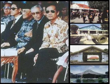
longest Javanese kingdom) before it was separated, as we saw nowadays, into a-four-kingdom as follows (see figure 1): PB (Paku Buwono); HB (Hamengku Buwono); MN (Mangku Negara) and PA (Paku Alam)
Figure 1. The Four King of Mataram and Their Javanese Kingdom
(Right-Left and Above-Below: King HB X and the Palace of Kasultanan Yogyakarta; King
PB XII and the Palace of Kasunanan Surakarta; King PA VIII and the Palace of Pakualaman
Yogyakarta; King MN IX and the Palace of Mangkunegaran Surakarta) (Source: Modified from Vorstensteden, 1998 and Survey, 2007)
RESEARCH QUESTION
1. How is the morphology of urban space of Solo in the early period?
2. How is the typology of urban space in of Solo in the early period?
question, the study needs a story and an artefact. The story is collected by searching primary and secondary files and supported by the artefact. This archives research use four standard research steps, as follows: (1) data compilation; (2) data analysis; (3) validation of finding; and (4) conclusion. To find an accurate data, the study needs a crosscheck and benchmark strategy. Crosscheck strategy will be conducted by composing and imposing the files. The primary files (collected from Javanese documentaries by Margana 2004): parintah, undhang-undhang, pranatan, piyagem, kakancingan, serat, gugat, penget) and the secondary files (collected from historian and researcher documents: Ricklefs, Lombard, Vorstensteden, Muljana, Notosusanto, Kartodirdjo, Sajid, Ronald, Ikaputra, Adishakti) were collected, composed and imposed to validate the findings.
The benchmark strategy will be conducted by referring the latest and the most credible document. The validity and credibility document was usually produced by a sophisticated technology that was coming from the new era. The old map, for example, which was produced in 1600s, was usually inaccurate. The maps of Java produced in XVII century by Bertius (1618), Hulsius (1625) and Jansson (1657), as we saw nowadays in the internet, were actually inaccurate. Island Java, which was usually called by Java Major, was firstly seen bigger than island Sumatra. For the years later (1700s), according to map of Chatelain (1719), the map was more accurate than the previous; because it showed that Java was seen smaller than Sumatra. For the next years
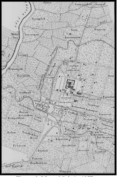
(1800s), according to the map of Witcamp (1893), Java was absolutely seen accurate. The benchmark strategy is the strategy that based on the several accurateness data then the study will set to them. Therefore, to explore the urban space of Solo in the early period, the map of Solo in 1857 is used to collected by interviews and field surveys. The documents were recorded by camera and scanner.
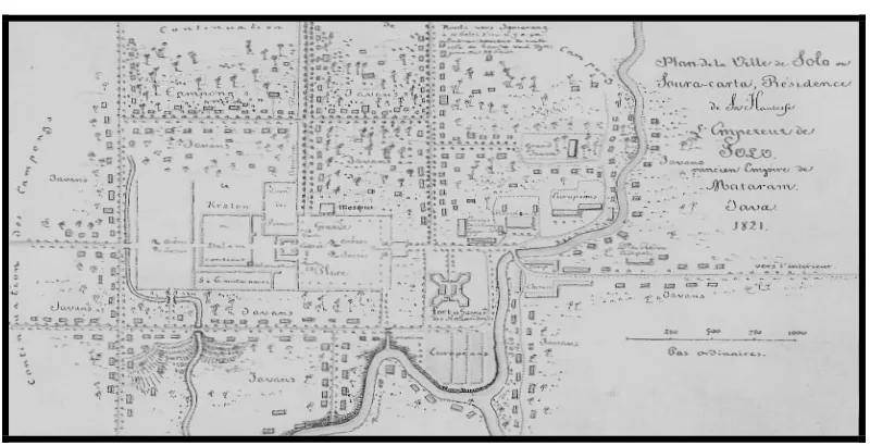
Figure 3. Map of Solo in 1821 as Benchmark-2 (BM-2) (Source: Vorstensteden, 1998)
REVIEW OF LITERATURE 1. Morphology
The word morphology stems from the Greek word morphos, meaning form. Morphology is the branch of biology which deals with the form and structure of animals and plants. Morphology in architecture, analogy with biology, is the study of form and structure of the space and built environment. It was concerned with the plan and builds of habitat, viewed and interpreted in terms of its origin, growth and function. Morphology of the town is a reflection of its function and the ideas of planning and building at each phase of its development. The study of morphology in architecture deals with the process of stand, rise and open of building in the environment. (Rose, 1979; Steadmen, 1983; Krier, 1984)
2. Typology
Typology in architecture can simply be defined as a concept which describes a group of objects characterized by the same formal structure. The study of typology in
and built environment. To raise the question of typology in architecture is to raise a question of the nature of the architectural work itself. To answer it means, for each generation, a redefinition of the essence of architecture and an explanation of all its attendant problems. A work of architecture has to be considered in its own right, as an entity in itself. That is, like other forms of art, it can be characterized by a condition of uniqueness. From this point of view, the work of architecture is irreducible within any classification. (Moneo, 1976; Rossi, 1982; Krier, 1984; Kostof, 1991).
3. Urban Space
(river, mountain, lake, etc.), buildings (office, market, hospital) and human (society, people, citizen). If we wish to clarify the concept of urban space without imposing aesthetic criteria, we are compelled to designate all types of space between buildings in towns and other localities as urban space. The space is geometrically bounded by a variety of elevations. It is only the clear legibility of its geometrical characteristics and aesthetic qualities which allows us consciously to perceive external space as urban space. (Krier, 1984; Kostof, 1991; Daldjoeni, 1997; Cohen, 1999).
DISCUSSION
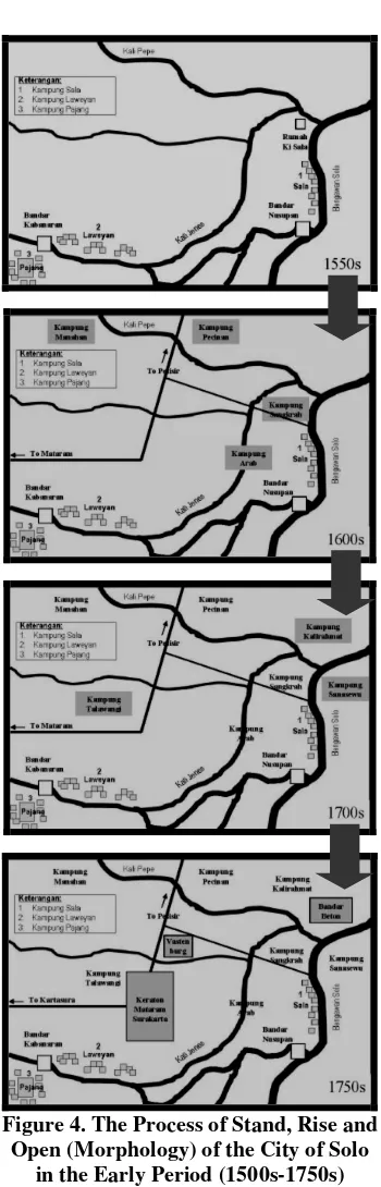
1. Morphology of Solo (1500-1750) According to Babad Tanah Jawi and Babad Sala, the history of urban space in Solo was established in 1500s. The process of stand, rise and open of urban space in Solo was equal to the period of Kadipaten Pajang, the part land of Demak. According to pranatan (king’s regulation) no. 4 (PB-II, 1726), kadipaten was the land which History of Indonesia (Muljana, 1968), was traditional trading and sailing. The early Solo setting played a role to be a part of foreign trading route. The traders passed through the Narrow Malacca and continued to visit Java northern coast cities, then came into the early Solo area by sailing through River Bengawan Solo.
2) Jaka Tingkir
Jaka Tingkir or Mas Karebet was grandchild of Sunan Kalijaga and the son of Kyai Pengging. In 1546, Jaka Tingkir had an authority as Adipati Pajang from Kingdom of Demak, as name Sultan Bintara III. Sultan who gives the power is actually his parent-in-law. The activities of the government in Pajang had strong impact in socio-economic of the society in Kampong Sala and Laweyan. In 1568, when Wali Sanga proclaimed Jaka Tingkir as the king, he moved the palace of Demak to Pajang. By the time, Jaka Tingkir became the King of Pajang with the title of Sultan Hadiwijaya. The surroundings of Pajang had more and more impact in social, economic, politics and army. In 1586, the son of Sultan Hadiwijaya, Pangeran Benowo, became the king of Pajang, but the power brought to Panembahan Senopati in 1589. He is the grandchild of Kyai Ageng Laweyan or the son of Kyai Ageng Pemanahan. By the time, Kraton Pajang moved to Mataram, Kotagede.
3) Kyai Ageng Pemanahan
Kyai Ageng Pemanahan, the son of Kyai Ageng Laweyan, was the closed staff of Sultan Hadiwijaya. Kyai Ageng Pemanahan lived in Kampong Manahan. He had reward the land of Mataram after he had helped the Sultan in attacking Arya Penangsang. After forming Mataram, Kyai
Ageng Pemanahan with his son,
Panembahan Senopati, moved and lived in there in 1577. In 1589, Panembahan Senopati was nominated as the king of the new Mataram Java, after Pangeran Benowo in Pajang given him the authority. According to the primary, secondary and physically files, the morphology of
Figure 4. The Process of Stand, Rise and Open (Morphology) of the City of Solo
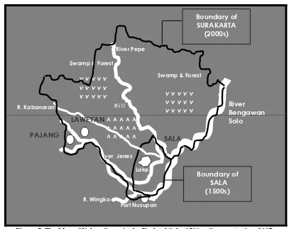
Figure 5. The Map of Urban Space in the Early of Solo (1500s) (Source: Author, 2007)
2. Typology of Solo (1500s-1750s)
Based on the map of the element of land, human and buildings, the urban space in the early of Solo can be identified into 3 types: beside on river (Kampong Sala), near to river (Kampung Laweyan)
and far from river (Kampung Pajang). According to the distance from the river, type of the urban space and the type of user, herewith the matrix and the table of typology of Urban Space in the early of Solo (1500s) as follows:
! "
#$%&& '
()*
! "
+ ,
#-&&& '
(
Table 1. Urban Space Typology of Solo in the Early Period (1500s-1750s)
No. Located Distance Type Pattern User
1. Sala Beside on River Linear Civil Society (The labour of Port Nusupan)
2. Laweyan Near to River Cluster Middle Society (Industry of lawe)
3. Pajang Far From River Central Noble (the family of the King)
(Source: Author, 2007)
CONCLUSION
Morphology of urban space in the early of Solo is divided into 3 elements: the element of land, which is dominated by Bengawan Solo; the element of human, which is dominated by the trader; and the element of buildings, which is dominated by Kampong Sala. They formed the urban space as waterfront city in the early of Solo (1500-1700). When the Dutch and the Mataram Kingdom occupied (1750s), the urban space was combined by the land-city. According to the findings, the main urban space was firstly (1500s) constructed by the lowest social status in the early
period (morphology: stand era), while the next step, the developing era (morphology: rise and open era) was conducted by the highest social status (1750). The buildings have a vernacular material still, although they have met the Chinese and Arab/Indian.
Typology of urban space in the early of Solo is divided into 3 types: the linear (Kampung Sala); the cluster (Kampung Laweyan); and the central (Kampung Pajang). The different social status formed the different distance: beside the river (low status); near to river (middle status); and far from the river (high status).
REFERENCES
Adishakti, Laretna T., 1997, A Study on The Conservation Planning of Yogyakarta Historic-Tourust City Based on Urban Space Heritage Conception,Dissertation of Kyoto University, Japan.
Cohen, Nahoum, 1999, Urban Conservation, The MIT Press, Cambridge.
Daldjoeni, N., 1997, Seluk Beluk Masyarakat Kota, Penerbit Alumni, Bandung.
Ikaputra, 1995. A Study on the Contemporary Utilization of the Javanese Urban Heritage and its Effect on Historicity, Dissertation of Osaka University, Japan.
Kartodirdjo, 1975, Sejarah Nasional Indonesia 1, Dirjen Dikti Departemen Pendidikan dan Kebudayaan, Jakarta.
Kostof, Spiro, 1991, The City Shaped : Urban Patterns and Meanings Through History,Thames and Hudson, London.
Krier, Rob, 1984, Urban Space, Academy Edition, London.
Lombard, Denys, 2005, Nusa Jawa (Jilid 1-3), Gramedia, Jakarta.
Muljana, Slamet, 1968, Runtuhnya Kerajaan Hindu dan Timbulnya Kerajaan-Kerajaan Islam di Nusantara,Bharata, Jakarta.
Notosusanto, Nugroho dkk, 1992, Sejarah Nasional Indonesia III, Balai Pustaka, Jakarta.
Ricklefs, M.C., 2005. Sejarah Indonesia Modern, GMU Press, Yogyakarta.
Ronald, Arya, 2005, Nilai-nilai Arsitektur Rumah Tradisional Jawa, GMU Press, Yogyakarta.
Rose, Richard, 1979, Morphology in Architecture (Terjemahan),Arsitektur-UGM, Yogyakarta.
Rossi, Aldo, 1988, The Architecture of the City, Oppositions Books, Massachusetts.
Rossi, Aldo et al., 1982, Typology Readings, The MIT Press, Cambridge.
Sajid, 1984, Babad Sala, Rekso Pustaka, Solo.
Steadmen, J.P., 1983, Architectural Morphology: An Introduction to the Geometry of Building Plans, Pion Limited, London.
Sudibjo, 1980, Babad Tanah Jawi, Departemen P dan K, Jakarta.