Wahyu Catur Adinugroho
I N. N. Suryadiputra
Bambang Hero Saharjo
Labueni Siboro
Wahyu Catur Adinugroho
I N. N. Suryadiputra
Bambang Hero Saharjo
Labueni Siboro
Manual for the Control of
Manual for the Control of
Jl. A. Yani 53 – Bogor 16161 INDONESIA
Fax.: +62-251-325755 Tel.: +62-251-312189
General e-mail: [email protected] Web site: www.wetlands.or.id www.wetlands.org
Bogor, December 2005 Wahyu Catur Adinugroho I Nyoman N. Suryadiputra Bambang Hero Saharjo Labueni Siboro
Ditjen. PHKA Indonesia Programme
© Wetlands International - Indonesia Programme
Authors : Wahyu Catur Adinugroho
I Nyoman N. Suryadiputra Bambang Hero Saharjo Labueni Siboro
Editors : Bambang Hero Saharjo
Cover Design : Triana
Lay-out : Triana
Cover Photographs : Alue Dohong and Indra Arinal
ISBN: 979-99373-7-X
Reference :
Adinugroho W.C., I Nyoman N. Suryadiputra, Bambang H. Saharjo, and Labueni Siboro. 2005. Manual for the Control of Fire in Peatlands and Peatland Forest. Climate Change, Forests and Peatlands in Indone-sia Project. Wetlands International – Indonesia Programme and Wildlife Habitat Canada. Bogor.
iv
L
and and forest fire is a serious problem which Indonesia has to face in the dry season almost every year. Such fires occur not only on dry land but also on wetlands (mainly peatlands). Peatland forest fire is much more difficult to handle than fires on mineral soil or highland plains. This because the fire spreads not only through the vegetation on the surface of the peat but also through the underlying layer of peat itself, so it is difficult to determine the direction in which it is spreading. The only really effective way to extinguish peatland fires, especially when the fire has penetrated into very deep layers of peat, is from nature (i.e. heavy rain). Human fire-fighting efforts, besides requiring vast amounts of money and manpower, are not certain to extinguish the fires completely.This Manual for the Control of Fire in Peatland and Peatland Forest contains information on : (1) fire control, (2) factors which support fire, (3) government policy on fire control, and (4) strategies and techniques for the control of land and forest fires in peatland areas. The information presented in this book, besides including a variety of concepts and practical measures for the prevention and suppression of fire already written/presented by others, also contains ideas and recent field experience of the writers in the handling of land and forest fires in peatland areas of Kalimantan and Sumatera.
vi
4
We are aware that this Manual still has many deficiencies, and the writers would therefore welcome input in the form of criticisms and suggestions from readers, in order to improve its quality. Finally, we would like to thank all those who have helped in the production of this Manual.
Bogor, December 2005
Thank you,
The Authors
Fuel : All organic materials, whether alive or dead, found in the earth (e.g. peat) and/or on the surface of the earth or above the earth (tree crown/canopy), which originate in the forest or land.
Beje : Beje is a rectangular pond constructed by the people (usually of Dayak descent) living in the peat swamp forest interior of Central Kalimantan to trap fish brought by overflowing rivers in the area.
El_Ninõ : A natural phenomenon characterised by excessive heating of
sea temperatures in the equatorial region of the Pacific Ocean, which generally occurs once every 4 or 5 years.
Green House Effect : The process in which radiation from the sun enters and is then trapped within the atmosphere as a result of greenhouse gases, leading to an increase in the Earth’s surface temperatures. Within certain proportions, the greenhouse effect is not bad because it results in the average ground temperature being 15oC rather than -18oC, thus providing the chance for life to exist on the earth’s surface.
Peat : A type of soil composed of piles of organic materials originating from plant remnants which are in or have been in the process of decomposition.
Green House Gases : Gases which directly or indirectly affect the
greenhouse effect, such as carbon dioxide (CO2), methane (CH4), dinitrogen oxide (N2O), Chlorofluorocarbon (CFC),
viii
4
Manual for the Control ofIrreversible drying : A condition in which peat experiences excessive drying, causing the structure/characteristics of the peat to become damaged and change into charcoal-like material which cannot retain water nor absorb nutrients.
Illegal Logging : The uncontrolled, irresponsible, unlicensed felling of trees.
Land and forest fire : The incidence of fire, whether natural or man-made, characterised by the unhindered spread of fire consuming fuel from the forest and land through which it passes.
Ground fire : Fire which burns organic matter below the ground surface, usually organic litter/humus and dry peat. It usually begins as a surface fire which then spreads slowly to all parts below the surface layer (soil) and is extremely difficult to extinguish.
Ditch/Canal : A channel constructed by the community to link a river with peat swamp forest in order to extract logged timber. In addition, there are also authorised channels constructed by the government for irrigation purposes (e.g. in the area of the aborted Peatland Project in Central Kalimantan).
Land and Forest Fire Control : All efforts comprising activities directed at the prevention, suppression and post-fire handling of land and forest fires.
Land and Forest Fire Prevention : All efforts, actions and activities carried out to prevent or reduce the likelihood of forest fire occurring.
Land and Forest Fire Suppression : All efforts, actions and activities carried out to eradicate or extinguish fire which burns forest and land.
Community Participation : The process of community empowerment
Fuel break : This can be a natural break (such as a ravine, river, barren land, etc.) or a man-made one such as a road, reservoir, etc. which functions to separate one type of fuel from another.
Fire break : This can be a natural break (such as a ravine, river, barren land, etc.) or can be constructed by man to function (like blocked water-filled ditches) to separate, stop and control the spread of fire, or to maintain the strips of cleared land (ilaran) made to suppress forest fire.
Communal/Participatory fire break : A fire break, the construction of which involves the participation of the community, and which provides two benefits, i.e. (1) as a fire prevention measure and (2) to give economic benefit to the local community (for example, the blocked ditches and beje ponds function not only as fire breaks but also as fish ponds).
Small grant : The provision of collateral-free grants on a small scale to local community groups in order to develop a permanent business activity which does not damage the environment, in return for which grant the community group is obliged to protect the unburnt areas of peat land and forest and to rehabilitate those areas of peat land and forest which have already been degraded.
Zero Burning : A method of land clearing which does not utilise fire, but is carried out by cutting down trees in secondary forest or old plantations (e.g. oil palm), then shredding them into chips which are then piled into heaps and left to decompose naturally.
Post Fire Measures following Land and Forest Fire : All efforts,
AATSR Along Track Scanning Radiometer
ADB Asian Development Bank
APHI Asosiasi Pengusaha Hutan Indonesia (Indonesian Association of Forestry Concession Companies)
ASAR Advanced Synthetic Aperture Radar
ASEAN Association of Southeast Asian Nations
AVHRR Advance Very High Resolution Radiometer
BAKORNAS PBP Badan Koordinasi Nasional Penanggulangan Bencana
dan Penanganan Pengungsi (National Coordinating Agency for Disasters and Refugees)
BMG Badan Meteorologi dan Geofisika (Meteorology and Geophysics Agency)
BAPEDAL Badan Pengendalian Dampak Lingkungan
(Environmental Impact Control Agency)
BAPPENAS Badan Perencanaan Pembangunan Nasional (National
Development Planning Agency)
BP2HTIBT Balai Penelitian dan Pengembangan Hutan Tanaman
Indonesia Bagian Timur (Eastern Indonesia forestry research and development agency)
xii
4
Manual for the Control ofCFFPI Climate Change, Forest and Peatland Indonesia
CIDA Canadian International Development Agency
CO Carbon Monoxide
CO2 Carbon Dioxide
DC Drought Code
DIRJEN Direktur Jenderal (Director General)
ESA European Space Agency
FDRS Fire Danger Rating System
FD Fire Danger
FFMC Fine Fuel Moisture Code
FWI Forest Watch Indonesia
GHG Green House Gas
GTZ Deutsche Gesellschaft fur Technische
Zusammenarbeit
GNRHL Gerakan Nasional Rehabilitasi Hutan dan Lahan
(National Movement for Land and Forest Rehabilitation)
HPH Hak Pengusahaan Hutan (Forest Concession Right)
HPHTI Hak Pengusahaan Hutan Tanaman Industri (Forest
Concession Right for Commercial timbers)
IFFM Integrated Forest Fire Management
KBDI Keech Byram Drought Index
KKN Korupsi, Kolusi dan Nepotisme (Corruption, Collusion and Nepotism)
LAPAN Lembaga Penerbangan dan Antariksa Nasional
LSM Lembaga Swadaya Masyarakat (Non Governmental Organisation)
MERIS Medium Resolution Imaging Spectrometer
MODIS Moderate Resolution Imaging Spectro-Radiometer
NASA National Aeronautics and Space Administration
NOAA National Oceanic and Atmospheric Administration
OR Organisasi Rakyat (People/Community Organisation)
P3K Pertolongan Pertama Pada Kecelakaan (First Aid)
PBP Penanggulangan Bencana dan Penanganan
Pengungsi (Handling of Disasters and Refugees)
PHKA Perlindungan Hutan dan Konservasi Alam (Forest Protection and Nature Conservation)
PHPA Perlindungan Hutan dan Pelestarian Alam (Forest Protection and Nature Conservation)
PLG Proyek Lahan Gambut (Peat Land Project also known as MRP, Mega Rice Project)
PLTB Pembukaan Lahan Tanpa Bakar (Zero Burning Land Clearance)
POSKO Pos Komando (Comando Post)
POSKOLAKDALKARHUTLA
Pos Komando Pelaksana Pengendalian Kebakaran Hutan dan Lahan (Commando Post for Land and Forest Fire Control)
PPKHL Pencegahan dan Penanggulangan Kebakaran Hutan
dan Lahan (Prevention and Suppression of Land and Forest Fires)
PUSDALKARHUTNAS
xiv
4
PUSDALKARHUTLA
Pusat Pengendalian Kebakaran Hutan dan Lahan (Land and Forest Fire Control Centre)
SAR Search and Rescue
SATGAS Satuan Tugas (Task Unit)
SATLAK Satuan Pelaksana (Implementation Unit)
SATLAKDALKARHUTLA
Satuan Pelaksana Pengendalian Kebakaran Hutan dan Lahan (Land and Forest Fire Control Implementation Unit)
SK Surat Keputusan (decree)
SSFFMP South Sumatra Forest Fire Management Project
TKNKL Tim Koordinasi Nasional Kebakaran Lahan (National
Coordinating Team for Land Fires)
TKNPKHL Tim Koordinasi Nasional Pengendalian Kebakaran
Hutan dan Lahan (National Coordinating Team for Land and Forest Fire Control)
TNI Tentara Nasional Indonesia (Indonesian Armed Forces)
UPT Unit Pelaksana Teknis (Technical Implementation Unit)
USA United States of America
UU Undang-Undang (Law)
WI-IP Wetlands International - Indonesia Programme
Foreword... v
Glossary ... vii
List of Abbreviations... xi
Table of Contents... xv
List of Appendices... xix
List of Tables... xx
Chapter 1. Introduction... 1
Chapter 2. Importance of Controling Land and Forest Fire in Peatland Areas... 3
2.1 Function and Potential of Peat Land and Peat Forest ... 3
2.2 Causes of Land and Forest Fire in Peatland Areas ... 6
2.3 Type of Fire in Peatland and Peat Forest Areas ... 8
xvi
4
Manual for the Control ofA. Degradation of the environment ... 9
B. Danger to human health ... 13
C. Change in Socio-economic values ... 13
Chapter 3. Factors Supporting Incidence of Land and Forest Fire in Peatlands Areas... 17
3.1 Climate Conditions ... 18
3.2 Physical Conditions ... 19
3.3 Economic, Social and Cultural Conditions ... 20
Chapter 4. Forest Fire Control Policy in Indonesia... 23
4.1 Policy ... 23
4.2 Institutions ... 29
A. The Forestry Sector ... 29
B. The Agricultural Sector ... 32
C. The Environmental Sector ... 32
D. The Disaster Management Sector ... 33
E. Other Sectors ... 33
Chapter 5. Strategy for the Control Fire in Peatland and Peat Forest... 35
5.1 Prevention ... 36
A. Fire Information System Approach ... 37
B. Socio-economic Community Approach ... 46
C. Land and Forest Management Approach ... 51
5.2 Fire Suppression ... 55
B. Identification and Mapping of Water
Sources ... 56
C. Funding Support ... 57
D. Supporting Facilities and Infrastructure ... 58
E. Identification of Smoke Free Areas ... 63
F. Organisation of Fire-fighting Teams for Land and Forest Fires in Peatland Areas ... 63
G. Standard Fire-fighting Procedure ... 65
5.3 Measures Taken After Land and Forest Fire ... 68
A. Fire Impact Assessment ... 68
B. Judicial Measures ... 69
C. Rehabilitation ... 70
Chapter 6. Fire Control Techniques for Land and Forest Fires in Peatland Areas... 73
6.1 Techniques for Public Awareness Raising ... 73
A. Making Warning Signs ... 74
B. Making Banners ... 77
C. Production of Brochures, Folders, Leaflets and Magazines ... 77
D. Production of Posters ... 78
E. Production of Fire Calendars ... 78
F. Production of Stickers ... 80
G. Production of Story Books ... 80
H. Video Production ... 80
xviii
4
6.2 Techniques to Involve Community in Land
and Forest Fire Control ... 83
6.3 Technique for Setting up a Community Fire Brigade ... 88
6.4 The Use of Fuel in Land Preparation ... 92
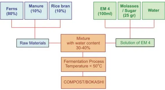
A. Making Compost ... 92
B. Manufacture of Charcoal Briquettes ... 99
6.5 Controlled Burning Technique ... 100
6.6 Utilisation of ‘Beje’ Ponds and Ditches as Communal Fire Breaks ... 105
A. Restrictions ... 106
B. Fire Breaks ... 106
6.7 Zero Burning on Peatland ... 115
A. Definition ... 115
B. Benefits of Zero Burning ... 115
C. Obstacles to the Implementation of Zero Burning ... 116
D. Zero Burning for Replanting on Peatland ... 116
6.8 Techniques for Suppression of Land and Forest Fire in Peatland Areas ... 121
References... 125
LIST OF APPENDICES
Appendix 1. A brief description of several regulations
pertaining to policy on land and forest fire control in Indonesia ... 131
Appendix 2. List of Institutions concerned with land and forest fire, at regional, national and local levels ... 134
Appendix 3. List of Projects related to land and forest fire
in Indonesia ... 155
Appendix 4. Fire-fighting Equipment for Land and Forest Fire
xx
4
Manual for the Control ofLIST OF TABLES
Table 1. Standard Criteria for Damage to Physical
Characteristics of Peat due to Fire ... 10
Table 2. Standard Criteria for Damage to Chemical
Characteristics of Peat due to Fire ... 11
Table 3. Area of Peat Land and Forest Fires in 1997/1998 in
Indonesia ... 17
Table 4. Economic Benefits derived from Direct Utilisation of Forest Products from the Perian Forest Area,
in 2000 ... 21
Table 5. Policy on Land and Forest Fire in Indonesia ... 25
Table 6. Important Institutions Involved in Land and Forest Fire Management at the International/Regional, National, Provincial and District (Kabupaten) /
Municipal Levels ... 34
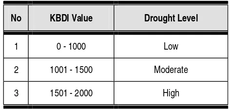
Table 7. Drought Level Interpretation ... 39
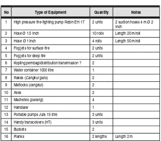
Table 8. One Set of Fire-fighting Equipment for Land and
Forest Fire in Peatland Areas, for one team of
15 persons ... 60
Table 9. Nutrient content of various organic fertilisers ... 93
Introduction
T
he general public’s perception of the fires which have occurred so frequently in recent years is that they occur only in the forest, whereas in fact they can just as easily occur outside the forest. Forest and land fires should be seen together as one inseparable whole and tackled as such.Forest fires in Indonesia at the present moment can be viewed as a regional and global disaster. This is because their impact has spread to neighbouring countries and the gases they release into the atmosphere (such as CO2) are potential causes of global warming.
Forest fires in Indonesia occur not only on dry land but also on wetland such as peatland / peat-forest, particularly during the dry season when the wetlands dry out. Large scale clearing of peatlands with the digging of canals has further increased the risk of fire breaking out during the dry season, as the groundwater drains away through the canals leaving the peat excessively dry and easily combustible. Irreversible drying occurs and the peat changes character becoming like charcoal, as a result of which it is no longer capable of absorbing nutrients or retaining water.
number of parties; although their results differ, they do show that more than 1 million hectares of Indonesia’s peat swamp were burnt during 1997/1998. Tacconi (2003) estimates that the total area of peat and mangrove forest burnt in Indonesia in 1997/1998 reached 2,124,000 hectares.
Overcoming fire in peat land/forest is extremely difficult, compared with fire in areas where there is no peat. The spread of ground fire in peatland is difficult to detect because it can extend down to deeper levels or to more distant areas without being visible from the surface. On peatlands, if a fire is not quickly suppressed, or if it has already penetrated far into the peat layer, it will be difficult to extinguish. Moreover, the main obstacles to putting out the fire are the difficulty in obtaining large quantities of water nearby, and the extreme difficulty in gaining access to the site of the blaze. For these reasons, severe/extensive peatland fire can only be extinguished by natural means, i.e. by heavy rain.
Despite the many studies which have been done on forest fire, little progress has been made on ways of overcoming the problem of such fires, particularly those in peat land and forest, which continue to recur from year to year, especially in the dry season. This Manual is therefore intended to provide input and alternative choices for dealing with the problem of land and forest fire, especially that occurring in peatland areas. It is contains a variety of illustrations and diagrams which are easily comprehensible/practical and will, it is hoped, facilitate their application in the field.
2
Importance of Controling Land and Forest Fire
in Peatlands Areas
2.1 FUNCTION AND POTENTIAL OF PEAT LAND AND PEAT FOREST
P
eat soil forms from the accumulation of remnants of dead prehistoric vegetation, part of which has undergone decomposition. It has a minimum organic Carbon content of 12-18% and a minimum thickness of 50cm. Taxonomically, it is termed peatland, Histosol or Organosol if it has a peat layer of e”40cm and bulk density of e”0.1g/cm3 (Widjaja Adhi, 1986). The term ‘peat’ has two meanings; it is used to refer to the organic material itself (peat) and also to the type of soil (peat soil). As an organic material, peat is a source of energy, a medium for seed germination, and an organic fertiliser, while as an organic soil it is used for agriculture and can be managed through a system of farming (Andriesse, 1988). Three types of organic soil have been identified based on the level of decomposition of their original plant material (Andriesse, 1988 and Wahyunto et al 2003); these are fibric, hemic and sapric.Peat swamp forest (Jill Heyde -ccfpi.doc)
Box 1
Field Study, 2001
MACRO BIODIVERSITY of the BLACK WATER ECOSYSTEM in CENTRAL KALIMANTAN by the Indonesia Center for Biodiversity and
Biotechnology
1. 82 species of tree (9 protected tree species) ;
2. 17 species of grasses and wooden shrubs;
3. 85 species of fungi;
4. Average density (number/hectare): Trees : 371.74 /ha ; Pole : 984 /ha; Sapling: 3,868.89 /ha; Seedlings : 27,680.56 sm/ha
5. 17 species of birds 6. 16 species of fish
7. 15 species of other wildlife
The peat ecosystem is special in that, if it has not been disturbed, it will be inundated every year. Another special characteristic of peat is that, compared to other natural resources, it can be utilised both as “land” and also as “material” (Setiadi, 1999). Peatswamp forest has many functions, including:
as an aquifer, to store water reserves
as an environmental/ecological buffer
as agricultural land
as habitat for flora (vegetation) and fauna (fish, birds, other wildlife etc.)
as a raw material for making charcoal briquettes and growth media for plants
as a carbon sink; peat has the capacity to store and sequester large amounts of carbon and thus restrict the emission of greenhouse gases into the atmosphere.
Peatland is of little economic value but has an extremely important ecological function. Hydrologically, for example, it plays a vital role in regulating flow and storing water. Because of their enormous capacity for absorbing water, peat swamps function to prevent flooding and reduce the danger of flood.
4
Ramin Belangeran Jelutung Peat has a unique ecosystem rich in biodiversity [box 1]. Species of flora include: durian burung (Durio carinatus), ramin (Gonystylus sp), terentang (Camnosperma sp.), Gelam (Melaleuca sp), Gembor (Alseodaphne umbeliflora), Jelutung (Dyera costulata), Kapur naga (Callophyllum soulatri), Kempas (Koompassia malacensis), Ketiau (Ganua motleyana), Mentibu (Dactyloclades stenostachys), Nyatoh (Palaqium scholaris), Belangiran (Shorea belangeran), Perupuk (Lophopetalum mutinervium), rattan, pandan, palms and various species of liana.
Species of fauna found in peat swamp areas include Orang-utan, deer, crocodiles, wild boar, long-tailed monkeys, reddish short-tailed monkeys, proboscis monkeys, short-tailed macaque, gibbons, monitor lizards, Bidaung (a kind of monitor), pythons, Ular tedung (cobra snake ?), Beruang madu/sun-bears, Macan pohon/Neofelis nebulosa, various species of fish (Tapah/ Giant malayan catfish Wallago leeri, Lais/Catfish Kryptopterus spp, Baung/River catfish Macrones nemurus, Seluang/ Rasbora Rasbora spp, Toman/Giant snakehead Channa micropeltes, Patin/Pangasius Pangasius sp,
Sepat/ Three-spot gouramy Trichogaster trichopterus, Kalui/ Kissing gouramy Helostoma temminckii, Kapar/ Javan combtail Belontia hasselt,
Orang-utan (Pongo pygmaeus)
Papuyuk/ Climbing perch Anabas testudineus, Pentet/Common walking catfish Clarias batrachus, Biawan/Mud perch Pristolepis groitii and a wide variety of bird species which use the area either as a habitat or place of migration: owls/Brown boobok/Hawk-owl Ninox scutulata, coucal/ bubut Cuculidae, Tinjau/Robin/Shama Copsychus spp, Antang (eagle/ hawk)/Brahminy kite Haliastur indus, Pempuluk/Bulbul Pycnonotidae, Pigeons/punai/Green-pigeons Treron spp, Sebaruk/ egrets/herons/ bangau/Lesser adjutant Leptoptilos javanicus, swifts/Little swift Apus affinis, parakeets/Long-tailed parakeet Psittacula longicauda, Putar doves/ Spotted dove Streptopelia chinensis, mynah/Hill myna Gracula religiosa, woodpeckers Picidae and Tinggang/Rhinoceros hornbill Buceros rhinoceros).
Peat is also a component of fuel which is found below the surface. Peat’s enormous capacity for absorbing water means that even when the soil in its upper part is dry, that lower down remains damp, even wet because it still contains water. Thus the lower fuel layer has a higher water content than the surface layer (organic litter, twigs, logs) and upper layer (canopy, moss, epiphyte). During the dry season, the surface peat soil dries out very quickly and easily catches fire. When it burns, the fire in the peat mixes with steam, resulting in copious amounts of smoke.
2.2 CAUSES OF LAND AND FOREST FIRE IN PEATLAND AREAS
In general, the cause of land and forest fires in Indonesia is 99.9% human, whether intentional or accidental, while the remaining 0.1% is due to natural causes (lightning, volcanic lava).
Human causes of fire can be categorized as follows:
a. Land conversion: conflagration resulting from the use of burning to clear land to make way for agriculture and industry, for the construction of roads, bridges, buildings, etc.
6
b. Burning of vegetation: conflagration resulting from the intentional burning of vegetation, where the fire gets out of control and jumps; for example, in the clearing of land on HTI and Plantation estates; farmers burning their fields in preparation for planting
c. Exploitation of natural resources: conflagration resulting from activities which take place during the exploitation of natural resources. These include the burning of undergrowth which obstructs access, and the lighting of cooking fires, by illegal loggers and fishermen in the forest. Their negligence in extinguishing these fires causes conflagration.
d. Construction of canals/channels in peatland. These canals are generally used for transporting logs or for irrigation. Channels which are not equipped with adequately functioning water control gates cause the water to drain out of the peat layer, with the result that the peat becomes dry and highly combustible.
e. Land rights/ownership. Fire is often used as a tool by the local community to reclaim their rights to land or to take over ‘ownerless’ land in their vicinity.
Saharjo (1999) states that whether they occur in HTI areas, natural forest or shifting cultivation, 99% of forest fires in Indonesia can be ascribed to human causes, whether the fire is started intentionally or sparked off accidentally as a result of negligence during the burning of fields. Fuel and fire are important factors in preparing land for agriculture and plantations (Saharjo, 1999). In addition to being cheap and easy, burning also produces minerals which can be absorbed easily by plants.
2.3 TYPE OF FIRE IN PEATLAND AND PEAT FOREST AREAS
Fire in peatland areas is categorized as ground fire. This type of fire spreads unpredictably and slowly because it is not affected by wind; smouldering beneath the surface, the organic matter burns without flame, giving rise to white smoke which is the fire’s only visible sign above the surface. Ground fire does not happen of its own accord; usually the fire originates on the surface then spreads downwards burning organic matter through the pores of the peat, burning buried logs and spreading through the roots of undergrowth whose tops are burning. As it develops, the fire spreads vertically and horizontally, like a chimney of smoke. Tree roots held by the peat burn, thus losing their grip on the soil, with the result that the trees topple over. Fallen trees whose crowns are still green are a common sign of peat fires. Considering that the fire is below ground with only the smoke appearing at the surface, attempts to extinguish this type of fire are fraught with difficulties. Peatland fires can only be completely extinguished if the whole layer of burning peat is inundated with water. Obviously, to do this requires huge quantities of water, for example through the use of pump sticks, or waiting until the fire is extinguished naturally by heavy rain.
Ground Fire
2.4 IMPACT OF LAND AND FOREST FIRE IN PEATLAND AREAS
Land and forest fires in peatland areas have an obvious detrimental effect as regards degradation of the environment, human health and the socio-economic conditions of the local communities.
8
Fire conditions (Alue dohong-ccfpi.doc)
A. Degradation of the environment
Fire results in :
Decline in the physical quality of the peat. (reduction in total porosity, water content and permeability).
The effect of fire on the soil’s physical characteristics is not only determined by the duration and frequency of the fire and the degree of damage/ decomposition caused, but is also a result of the heating that occurs at the surface, which is affected by the availability
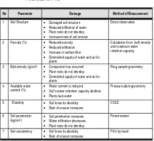
No Parameter Damage Method of Measurement
1 Soil Structure • Damaged soil structure • Reduced infiltration of water • Plant roots do not develop • Increased rate of soil erosion
Direct observation
2 Porosity (%) • Reduced porosity • Reduced infiltration • Increase in surface flow
• Diminished supply of water and air for plants
Calculation from bulk density and maximum water retention capacity
3 Bulk density (g/cm3) • Compaction has occurred
• Plant roots do not develop • Diminished supply of water and air for
plants
Ring sample-gravimetry
4 Available water content (%)
• Water content is reduced
• Soil’s water retention capacity declines • Plants lack water
Pressure plate-gravimetry
5 Elasticity • Soil loses its elasticity • Rate of erosion increases
COLE
6 Soil penetration (kg/cm2)
• Soil penetration increases • Water infiltration decreases • Plant roots do not develop
Penetrometer
7 Soil consistency • Soil loses its plasticity • Rate of erosion increases
Fill it by hand
Table 1. Standard Criteria for Damage to Physical Characteristics of Peat due to Fire
*Source: Appendix to Government Regulation PP No 4, 2001
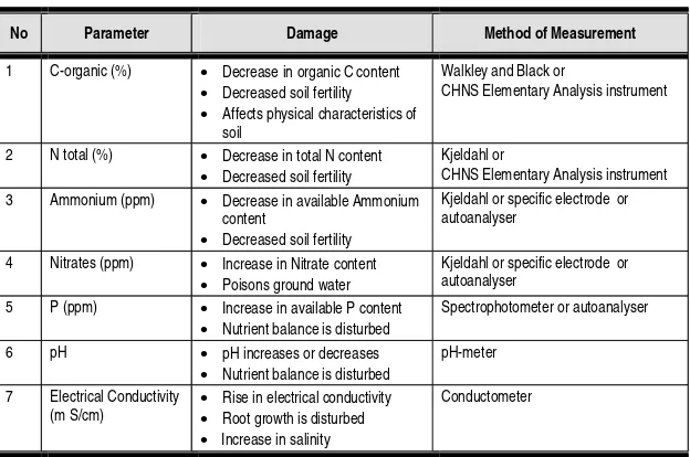
Changes to the peat’s chemical characteristics
The effect of fire on the peat’s chemical characteristics is also determined by the level of decomposition and the supply of fuel on the surface, which will give rise to heating and the production of mineral rich ash. The change which occurs in the chemical characteristics of the peat, particularly immediately following the fire, will be marked by increases in pH, total-N content, Phosphorus content and total alkali content (Calcium, Magnesium, Potassium, Sodium) but a decrease in organic Carbon content. However, these changes are only temporary, because several months after the fire (usually about 3 months) further chemical changes will occur: there will be a decrease in pH, total-N content, Phosphorus content and total alkali content (Calcium, Magnesium, Potassium, Sodium).
10
No Parameter Damage Method of Measurement
1 C-organic (%) • Decrease in organic C content • Decreased soil fertility • Affects physical characteristics of
soil
Walkley and Black or
CHNS Elementary Analysis instrument
2 N total (%) • Decrease in total N content • Decreased soil fertility
Kjeldahl or
CHNS Elementary Analysis instrument 3 Ammonium (ppm) • Decrease in available Ammonium
content
• Decreased soil fertility
Kjeldahl or specific electrode or autoanalyser
4 Nitrates (ppm) • Increase in Nitrate content • Poisons ground water
Kjeldahl or specific electrode or autoanalyser
5 P (ppm) • Increase in available P content • Nutrient balance is disturbed
Spectrophotometer or autoanalyser
6 pH • pH increases or decreases • Nutrient balance is disturbed
pH-meter
7 Electrical Conductivity (m S/cm)
• Rise in electrical conductivity • Root growth is disturbed • Increase in salinity
Conductometer
The changes in the peat’s chemical quality following fire is influenced by the supply of ash produced by the fire, drainage, the presence of damaged peat, changes in the ground cover, and micro-organism activity. These changes will subsequently affect the growth of vegetation on the soil.
Table 2. Standard Criteria for Damage to Chemical Characteristics of Peat due to Fire
* Source: PP No 4, 2001
Disturbance to the peat soil decomposition process, due to the death of micro-organisms in the fire
Loss/destruction of natural seedlings previously buried in the peat soil layer, with the result that succession or development in the population and composition of forest vegetation are also disturbed or altered, resulting in a decline in biodiversity
Box 2
Sequestered carbon in peat soil in Sumatera Island
The total area of peatland in the island of Sumatera in 1990 was around 7.20 million ha. By 2002, because of the effects of land utilization during the 12 preceding years, this area had shrunk by around 9.5% or 683,000 ha. Calculations of the carbon content of peat soil throughout Sumatera put the amount at around 22,283 million tons in 1990. By 2002, however, it had declined by 3,470 million tons (15.5%), leaving only 18,813 million tons in total. Calculations of the carbon content of peat soil in each province of Sumatera in 2002 showed that Riau Province had the highest amount of sequestered carbon (14,605 million tons of carbon), followed by South Sumatera (1,470 million tons), Jambi (1.413 million tons), Aceh (458 million tons), West Sumatera (422 million tons), North Sumatera (377 million tons), and the two lowest, Lampung (35 million tons) and Bengkulu (30 million tons).
Source : Wahyunto, S. et al, 2003. PETA LUAS SEBARAN LAHAN GAMBUT DAN KANDUNGAN KARBON DI PULAU SUMATERA (Map: Distribution of peatland and carbon content in Sumatra Island) 1990 - 2002. Wetlands International – Indonesia Programme & Wildlife Habitat Canada (WHC).
lead to sedimentation and changes in water quality in the rivers as well as a decline in fish populations and diversity in the waters. In addition, damage to peatland hydrology will cause floods in the rainy season and sea water intrusion in the dry season to extend further inland.
Peat stores carbon reserves [box 2]; if it catches fire, it will emit large amounts of carbon dioxide gas which, being a greenhouse gas, will exacerbate global warming.
Land and forest fires in peatland areas will produce CO2 and CO, leaving hydrocarbons. The CO gas results from incomplete combustion and is a major contributor to the emission of greenhouse gases which cause global warming. In addition to the CO, these fires also emit large amounts of particles detrimental to human health. These combine with the water vapour in the air, forming dense smog which has a widespread impact. According to studies by ADB, the 1997 peat fires produced carbon emissions of 156.3 million tons (75% of total carbon emissions) and 5 million tons of dust particles. However, in 2002 it became known that the total amount of carbon released during the land and forest fires in 1997/1998 was 2.6 Billion tons.
12
Box 3
Impact of smoke on health
According to Mr Uban, campaign coordinator for Wahana Lingkungan Hidup Indonesia (Walhi), talking on Radio Nederland, the town of Palangkaraya in Central Kalimantan was put on a level II State of Alert at the beginning of August 2003, which was shortly raised to level I Alert status on 16 August, due to the smog coming from land and forest fires in peatland areas. The smog blanketing the town restricted visibility to just a few dozen metres in the afternoon. Although it was still possible to carry on with daily activities, the smog seriously impaired the health of the people in the area. Since July 2003, thousands of inhabitants have been reported to be suffering from respiratory infections, eye diseases and coughs.
B. Danger to human health
In 1997, the smoke from the land and forest fires in Indonesia covered eleven provinces mainly in Sumatera and Kalimantan, as well as parts of neighbouring countries such as Singapore, Malaysia and the Philippines. The excessive amounts of smoke produced during these fires gave rise to a number of ailments such as respiratory diseases, asthma, bronchitis, pneumonia, skin complaints and eye irritations. As many as 23,000 cases of respiratory diseases were reported in Central Kalimantan, 35,358 in Jambi, 47,565 in West Sumatra and 22,650 in Padang city. All together, more than 20 million of Indonesia’s inhabitants were affected by the smoke from the 1997 forest fires (Suratmo,1999). Moreover, the effects of smoke have to be endured every year [Box 3] as fires continue to occur almost every year in the dry season.
C. Change in Socio-economic values
A direct impact of fire on the community is the loss of various sources of income, particularly for those people who still depend on the forest for their livelihoods (agriculture, animal husbandry, hunting, fishing). Followings are direct impacts of the fire on several matters:
Box 4
Report by Local Inhabitants near Lake Sentarum National Park
A number of inhabitants near the Lake Sentarum National Park in West Kalimantan reported that their production of wild honey had fallen sharply, and in some areas had totally disappeared, because the honeybees had fled when their peatforest habitat was burnt.
When fields and plantations burn, all the vegetation is destroyed, including crops. For example, fires and the extended dry season of 1997/1998 in Indonesia caused 450,000 ha of paddyfields to be without water and as a result the harvest failed. Fire and drought affecting 60,000 ha of coffee, oil palm, rubber, cacao and sugar cane plantations led to a severe drop in the production of estate crops. When the subsistence and commercial activities of communities around the peatland and its forest are disturbed, the people will look for alternatives, which may in turn have secondary consequences, both social and ecological. The impact of fire on the local community is deeply felt and affects their work productivity. Land and forest fires in peatland areas have a strong impact on local earnings, because they destroy the crops which the community have planted [Box 4]. This loss reduces the amount of money the community will have to spend on their own primary needs. It also causes food shortages as the food-producing fields and gardens have been destroyed. Land and forest fires in peatland areas have serious social/psychological and ecological implications. The deep impact on the community, their feeling of neglect and despair, is often ignored. They feel that they have lost much and received no help nor even any acknowledgement of their loss. Such feelings constitute a socio-cultural impact which, if ignored, could lead to serious social conflict (Tacconi, 2003).
Timber Production
When production forest (HPH/HPHTI) is destroyed by fire, many commercial species are burnt, with the result that timber production will decline. Moreover, timber production will fall not only during
14
the period of the fire but also for several decades thereafter, and this will endanger the continued existence of the timber industry, such as sawmills, plywood manufacturers, papermills, etc.
Transportation
One of the direct effects of smoke from land and forest fires is a reduction in visibility, thus disrupting transportation, not only in the air but also on land and by water, and leading to a sharp decrease in transportation activity. Traffic accidents occur easily, for example tanker collisions, air crashes and road accidents. During the 1997 fires, 313 flights were cancelled in Sumatera and Kalimantan, resulting in losses of around Rp.100 billion to airlines and airports.
Area of Forest and Land (including peat) burnt (Source : Bappenas-ADB, 1999 ; FWI)
Tourism
Fire-fighting Costs
The cost of extinguishing land and forest fires is extremely expensive, especially when it involves the use of sophisticated up-to-date equipment such as aeroplanes and helicopters, and then on top of that there is the cost of rehabilitation after the fire. The fires in Indonesia in 1997/1998 mobilised not only all the employees of the forest managers but also the wider community, the military and the police.
Relations with Neighbouring Countries
Protests and claims were made by neighbouring countries who felt they had suffered losses as a result of the smoke from land and forest fires in Indonesia. In modern law, transboundary haze pollution can be categorized as an international crime, so it is not impossible that the international world could impose embargos or boycotts against Indonesian forest products if Indonesia is unable to overcome land and forest fires (Saharjo,2000).
In 1982/1983, land and forest fires in Indonesia destroyed an area of 3.6 million Ha. Large scale land and forest fires occurred again in 1994 and 1997/1998 destroying 5.11 million Ha and 10 million Ha respectively.
It was the forest fires of 1997/1998 that opened the world’s eyes to the fact that serious mistakes had been made in the management of Indonesia’s forests. The smoke from these land and forest fires covered the Southeast Asian region, enveloping several major cities such as Kuala Lumpur and Singapore, disrupting traffic by air, sea and land, and causing serious health problems.
16
Factors Supporting Incidence of Land and
Forest Fire in Peatland Areas
T
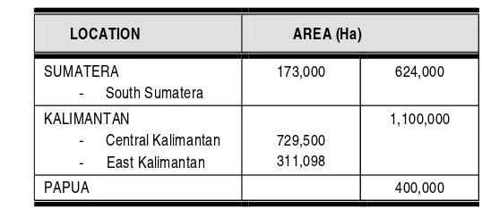
he biggest tropical forest fire to occur in tropical forest was in 1982/1983 in East Kalimantan; it burnt approximately 3.6 million ha of forest, including 550,000 ha of peatland forest (KLH-UNDP, 1998). Fires occurred not only in East Kalimantan but also in other parts of Kalimantan as well as in Sumatera, especially in peatland areas. These fires have recurred year after year in the dry season like an annual plague which is difficult to cure, particularly in 1982, 1991, 1994, 1997/1998 and 2002. In 1997/1998, Indonesia experienced the world’s worst land and forest fires. Over 2,000,000 ha of peatland were burnt, and are estimated to have emitted enough greenhouse gases to make a sizable contribution to global climate change. According to investigations by a number of parties, the areas of peat land and forest burnt in 1997/1998 were in Sumatera, Kalimantan and Papua [see Table 3], although this does not exclude the possibility that fire may have occurred in other regions also but not been observed.Table 3. Area of Peat Land and Forest Fires in 1997/1998 in Indonesia
LOCATION AREA (Ha)
SUMATERA
- South Sumatera
173,000 624,000
KALIMANTAN
- Central Kalimantan - East Kalimantan
729,500 311,098
1,100,000
PAPUA 400,000
Although peatswamp is categorized as wetland, being inundated every year, nevertheless it becomes dry and susceptible to fire in the dry season. The fire danger level in peat land and forest is influenced by a number of factors, which include the following.
3.1 CLIMATE CONDITIONS
Climate conditions, especially during periods of low rainfall, are one of the factors which increase the likelihood of fire. The risk of fire breaking out in peat land and forest is highest during the dry season, when rainfall is extremely low and the intensity of sunlight extremely high. Such conditions generally occur between June and October, and sometimes from May to November. The risk increases even further when the dry season coincides with the El Ninõ phenomenon. This was one of the factors that exacerbated the devastating fires of 1997/1998, when Australia and southern Africa experienced severe drought, and caused an increase in temperatures in Asia. El Ninõ is a natural phenomenon which is characterised by an excessive rise in sea temperatures in the tropical Pacific, and occurs at intervals of 4 or 5 years.
The risk of fire will start to decrease when rain begins to fall, i.e. during certain months of the wet season when there may be several days without rain. Under these conditions, fuel can still dry out and so fires can still occur.
The risk of fire becomes low when the wet season has stabilised, with rain falling every day. Under these conditions, the peatland and forest become inundated with water and the saturated fuel is difficult to burn.
18
Box 5
PLG
The large scale conversion of peatland for transmigrants’ housing and rice fields was a policy which the Indonesian government carried out through the ‘PLG’ one million hectare peatland project in 1995/1996.
This project was eventually discontinued, but it had already led to widespread environmental damage. Page et al (2002) reported that the use of fire for land clearing was the main cause of the fire and smoke pollution in Central Kalimantan in 1997. He reported that that the amount of peatland burnt in 1997 reached 0.73 million ha and was concentrated in the ex-PLG area. The construction of irrigation canals resulted in excessive drying out of peat in the dry season thus creating a fire hazard. The above picture shows one of the canals in block A of the ex-PLG which became neglected, experienced a drop in groundwater level and was burnt during the fires of 1997.
Aleu-ccfpi.doc
3.2 PHYSICAL CONDITIONS
The physical condition of degraded forest and land is one of the factors that can trigger fire. The degradation of peat land and forest is caused by illegal logging, and the conversion of peat land and forest for housing, ricefields, plantations and mining. Moreover, the presence of ditches/ channels constructed by the community to remove logs from the forest also degrades the forest even further. Illegal logging has opened up the forest and left an accumulation of waste which becomes a source of fuel. The conversion of peat land and forest for housing, ricefields and plantations has encouraged the use of fire in land clearing [see box 5].
Canal in PLG (Alue dohong – ccfpi.doc) Ditch on Simpang Kiri village (Sumatera) (YRN – ccfpi.doc)
Inhabitants of the peat ecosystem buffer zone (Alue dohong – ccfpi.doc)
3.3 ECONOMIC, SOCIAL AND CULTURAL CONDITIONS
Peatland is generally swamp land which is poor in nutrients and inundated with water every year, as a result of which it is not suitable for agriculture. Thus, these conditions force the inhabitants to survive through hunting, fishing and illegal logging. At the time of writing, illegal logging had decreased slightly as, all the commercial species of tree in this area having been exhausted, the loggers now have to go deep into the forest where access is more difficult. The community have also become increasingly aware of the detrimental impact of illegal logging; this is partly a result of the awareness campaigns and advice from NGOs and government, and also because they are now experiencing the impact directly themselves.
20
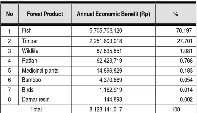
No Forest Product Annual Economic Benefit (Rp) %
1 Fish 5,705,703,120 70.197
2 Timber 2,251,603,018 27.701 3 Wildlife 87,835,851 1.081 4 Rattan 62,423,719 0.768 5 Medicinal plants 14,896,829 0.183
6 Bamboo 4,370,669 0.054
7 Birds 1,162,919 0.014
8 Damar resin 144,893 0.002
Total 8,128,141,017 100
Source : Survey WI-IP (2000);
Information obtained from local inhabitants indicates that there has been a reduction in the economic benefits derived from the forest, not only from fish production but also timber and all the other types of forest product. Fire and the irresponsible exploitation of forest resources have caused damage to habitats and resulted in the death of several species of animals and plants. The impact of this has been a fall in the production levels of forest resources. As these are the local people’s primary source of income, the community’s economic situation has deteriorated as a result
The results of a survey conducted by Wetland International – Indonesia Programme in the Perian forest area of PT. ITCI, East Kalimantan in 2000 show that the peatswamp forest provides substantial direct economic benefits, to a total value of Rp.8,128,141,017/year [see Table 4]. The greatest of these is fish (70.2%), which are used both for commercial gain and for subsistence. The second biggest is timber (27.707%).
The culture of dependence on natural resources has encouraged uncontrolled, irresponsible exploitation. The local community is sometimes used by certain parties to exploit natural resources recklessly (illegal logging, trading in protected species, the use of electricity or poison to catch fish, etc.). It is this that threatens to wreck forest conservation.
That forestry and plantation entrepreneurs are still relatively unaware of the need to allocate funds for the prevention of forest fire is evident from the way that land is prepared. Even though the company director advocates that land be cleared without the use of fire, in practice inadequate funding coupled with a lack of supervision encourage the contractor to use fire because it is cheap. The fire then gets out of control and spreads.
The tendency to pass the buck and to cover up fires when they occur means that steps to put them out are delayed, while the fire continues to spread and becomes increasingly difficult to extinguish. As a result, a new firefighting budget is proposed, which in practice is in danger of being corrupted by ‘KKN’ (‘Corruption, Collusion and Nepotism’). These issues were raised during “A one-day National Workshop on Fires in Indonesia : Impacts, Key Issues & Policy Responses, Jakarta 16 December 2003” held by CIFOR, where it was also reported that, even though much effort has been expended in the attempt to overcome the problem of fire, including the use of foreign aid, fire still continues to break out, especially during the dry season. What is needed right now, said Dicky Simorangkir, one of the speakers at the Workshop, is a commitment on the part of everybody to make a real effort to prevent fire. A similar sentiment was also expressed by FWI Director Togu Manurung, who stated that fire would be difficult to prevent in Indonesia so long as Corruption, Collusion and Nepotism continue to rampage.
22
Forest Fire Control Policy in Indonesia
4.1 POLICY
R
egulations and laws related to the Prevention and Suppression of Land and Forest and Fires are specified in Law No. 5 of 1990, Law No 5 of 1994, Law No. 23 of 1997, Law No 41 of 1999, and Regulation No. 4 of 2001. Steps to be taken in the suppression of forest and land fires comprise:a. Educate the general public about measures for the prevention and suppression of fires, through coordinated information activities, for example using the printed, electronic and other media.
b. Ban the use of burning, and educate the public in ways of preparing land without the use of fire (zero burning).
c. Improve the skills and capabilities of the work force, including the employees of both the state and private sectors.
d. Provide fire-fighting equipment in accordance with specified standards.
e. Carry out technical cooperation with donor countries.
f. Improve the welfare of communities living in the vicinity of the forest.
g. Impose strict penalties on every offender who violates the current laws and regulations.
Box 6
Responsibility for Land and Forest Fire Control
Land and forest fires produce smoke which is harmful to living creatures and are the joint responsibility of us all. According to Law no 41 of 1999 and Government Regulation no 4 of 2001, it is the duty and responsibility of each and every citizen, business, provincial government, local government and central government to deal with the problem of land and forest fires throughout Indonesia.
Every individual is under the obligation to prevent land and forest fire
The government is responsible for forest fire control in National forests
Business enterprises (individually owned businesses, private/state/regional companies, cooperatives, foundations) are responsible for fire control at the site of their business operation
Fire control in forest concession areas is to be carried out by the concession holder
Box 7
Penalties for Causing Forest Fire
Strict legal penalties for persons causing fire are stipulated in Law no. 41 of 1999, article 78 clauses 3, 4 and 11, as follows :
Intentionally setting fire to forest : Prison sentence maximum 15 years and a maximum fine of 5 billion rupiah
Negligence leading to forest fire : Prison sentence maximum 5 years and a maximum fine of 1.5 billion rupiah
Dumping of materials which can cause forest fire : Prison sentence maximum 3 years and a maximum fine of 1billion rupiah
24
Details of the policy on the Prevention and Suppression of Land and Forest Fires (referred to as ‘PPKHL’) are shown in Table 5.
Table 5. Policy on Land and Forest Fire in Indonesia*
No Type of
Regulation Number Content
1 Law No.5, 1967 Main stipulations concerning forestry
2 Law No.5, 1990 Conservation of biological resources and their ecosystems
3 Law No.5, 1994 Ratification of the UN convention on biodiversity 4 Law No.6, 1994 Ratification of the UN convention on climate change 5 Law No.23, 1997 Environmental Management
6
Law
Law No.41, 1999 Principles of Forestry (replacing Law No.5, 1967) 7 Gov. Reg. No.28, 1985 Forest Protection
8
Government
Regulation Gov. Reg. No.4, 2001 Control of environmental damage and/or pollution in
relation to land and/or forest fires
9 No. 195/Kpts-II/1986 Instructions on Measures for Preventing and Extinguishing Forest Fires
10 No. 523/Kpts-II/1993 Guidelines on Protection in Commercial Forest Areas
11 No 188/Kpts-II/1995 Formation of the National Forest Fire Control Centre (PUS-DALKARHUTNAS)
12 No. 260/Kpts-II/1995 Instructions on Measures for Preventing and Extinguishing Fires
13 No. 365/Kpts-II/1997 National Mascot for forest fire control 14
Decree of the Minister for
Forestry
No. 97/Kpts-II/1998 Procedures for Handling Forest Fire
15 No. KEP-18/MENLH/3/1995 Formation of the National Coordinating Agency for Land Fires
16
Decree of the Minister for the
Environment No. KEP-40/MENLH/09/97 Formation of the National Coordinating Team for
Land and Forest Fire Control
17
Decree of the Minister for Home Affairs
No.364.152.233-255
Validation of Central Java Provincial Regulation Number 6, 1991 concerning Measures to Prevent and Extinguish Forest Fires in Central Java Province
18 No.243/Kpts/DJ-VI/1994
Technical Instructions for the Prevention and Suppression of Forest Fire in Commercial Forest Areas and other Utilisation Areas
19 No. 244/Kpts/DJ-VI/1994 Technical Instructions for Extinguishing Forest Fires
20 No. 245/Kpts/DJ-VI/1994 Standing Procedure for the Use of Forest Fire Fighting Equipment
21 No. 246/Kpts/DJ-VI/1994 Instructions for Making and Erecting Fire Signs
22 No. 247/Kpts-DJ-VI/1994 Instructions for the Standardisation of Facilities for the Prevention and Suppression of Forest Fires
23
No Type of
Regulation Number Content
24 No. 81/Kpts/DJ-VI/1995 Instructions for the Control of Land and Forest Fires
25 No. 46/Kpts/DJ-VI/1997 Technical Instructions for Personal Caution and Work
Safety in Fighting Forest Fires
26 No. 47 /Kpts/DJ-VI/1997 Technical Instructions for Controlled Burning
27 No. 48/Kpts/DJ-VI/1997 Technical Instructions for the Commando System for
Controlling Forest Fires
28
Repeal of SK Dirjen PHPA No 47/Kpts/DJ-VI/1997 concerning Technical Instructions for Controlled Burning
No.222/Kpts/IV-BPH/1997 Technical Instructions for the Preparation of Land for Industrial Forest Crops, without the use of Fire
30
Technical Instructions for the Preparation of Land for Estate Crops, without the use of fire
31 Perda Prop. DATI I South
Sulawesi No.2, 1982
Prevention and Suppression of Forest Fires, Grazing of Animals in National Forest, and the Harvesting of Forest Products
32 Perda Prop. DATI I South
Kalimantan No.10, 1984
Prevention and Suppression of Forest Fires, Grazing of Animals in National Forest, and the Harvesting of Forest Products
33 Perda Prop. DATI I South
Sumatera No.2, 1987
Measures for Preventing and Extinguishing Forest Fires in South Sumatera Province
34 Perda Prop. DATI I North
Sumatera No.16, 1987
Prevention and Suppression of Forest Fires, Grazing of Animals in National Forest, and the Harvesting of Forest Products
35 Perda Prop. DATI I Jambi
No.6, 1988
Measures for Preventing and Extinguishing Forest Fires
36 Perda Prop. DATI I East Nusa
Tenggara No.26, 1988
Measures for Preventing and Extinguishing Forest Fires
37 Perda Prop. DATI I Bengkulu
No.4, 1990
Measures for Preventing and Extinguishing Forest Fires in Bengkulu Province
38 Perda Prop. DATI I Southeast
Sulawesi No.5, 1990
Measures for Preventing and Extinguishing Forest Fires
39 Perda Prop. DATI I Central
Java No.6, 1991
Measures for Preventing and Extinguishing Forest Fires in Central Java Province
40 Perda Prop. DATI I East
Kalimantan No.7, 1992 Preventing and Extinguishing Forest Fires
41 Perda Prop. DATI I East Java
No.5, 1992 Forest Protection in East Java Province
42 Perda Prop. DATI I West Nusa
Tenggara No.14, 1993 Forest Fire Control
43 Perda Prop. DATI I West Nusa
Tenggara No.17, 1993
Grazing of Farm Animals in the Forest, Gathering of Grass and Food
44
Regional Regulations
Perda Prop. DATI I Lampung No.6, 1998
Measures for Preventing and Extinguishing Forest Fires in Lampung Province
26
No Regulation Type of Number Content
45
Decree of the Governor of Central Java
No.364/1/1987
Measures for Preventing and Extinguishing Forest Fires in Central Java Province
46 Decree of the Governor of Jambi No.36, 1993
Formation of the Forest Fire Control Centre (PUSDAL) in the Province of Jambi
47 Decree of the Governor of Maluku
No. 364.05.521, 1995 Land and Forest Fire Control Centre
48
Decree of the Governor of East Nusa Tenggara
No. 37 1995
Formation of a Forest Fire Control Team, an Implementation Unit, and a Provincial Forest Fire Brigade in East Nusa Tenggara
49
Decree of the Governor of West Sumatera
No. SK 364.430.1995
Formation of a Forest Fire Control Team, an Implementation Unit, and a Provincial Forest Fire Brigade in West Sumatera Province
50 Decree of the Governor of Lampung No.G/457/B.VII/HK/1995
Formation of the Land and Forest Fire Control Centre in Lampung Province
51
Decree of the Governor of the Special Region of Aceh (skr Nangroe Aceh Darussalam)
No.522.1/423/1995
Formation of the Provincial Forest Fire Control Centre in the Special Region of Aceh
52
Decree of the Governor of South Sumatera
No.7, 1995
Control Centre (PUSDAL), Commando Post (POSKOLAK) and Implementation Unit (SATLAK) for the Prevention of Forest Fire in South Sumatera Province
53 Decree of the Governor of Jambi No.182, 1995
Formation of a Coordinating Team for the Integrated Dissemination of Information on Smoke Suppression, at the Land and Forest Fire Control Centre in Jambi Province
54
Decree of the Governor of South Kalimantan
No. 035, 1995
Formation of the Land and Forest Fire Control Centre in South Kalimantan Province
55
Decree of the Governor of West Java
No.364/SK.1852.Perek/1995
Land and Forest Fire Control Centre (PUSDAL) in West Java Province
56
Decree of the Governor of Central Sulawesi
No.SK.188.44/4969/Dephut
Formation of a Land and Forest Fire Control Centre
57
Decree of the Governor of Southeast Sulawesi
No. 63, 1996
Formation of the Land and Forest Fire Control Centre in Southeast Sulawesi
58 Decree of the Governor of Bali No. 655, 1996
Formation and Membership Structure of the Land and Forest Fire Control Centre in Bali Province
59 Decree of the Governor of Jambi No.240, 1996
Formation of the Land and Forest Fire Control Centre (PUSDALKARHUTLA) in Jambi Province
60 Decree of the Governor of West Java No. 367/Kep.1163-Binprod/2001
Formation of the Land and Forest Fire Control Centre in West Java Province
61
Decree of the Governor (Head of Province)I
Decree of the Governor of Riau No.Kpts 25/V/2000
Formation of the Land and Forest Fire Control Centre in Riau Province
Although there are many detailed policies concerning land and forest fire control, it can be said that these regulations are still inadequate and sectoral in nature. Most of them have been issued by the Ministry of Forestry, and have relatively little legal force because they are valid only within the working area of the Ministry, whereas fire occurs not only in forests but also on other land. Moreover, in several areas, wildfires tend to result from the use of fire by the agricultural sector, including plantation companies, and recently fires have even started to flare up in mining activities.
Legal action against those responsible for causing fire imposes maximum penalties and fines which do little to discourage the perpetrators, because under this system the perpetrators receive much lighter sentences than they should and may even get off free. [see box 7]
The speed at which Indonesia has been moving towards implementing a system of regional autonomy, under Law No. 22 of 1999, can also lead to increased deforestation, as local governments do not generally possess the capability nor the funds necessary to carry out effective government, so their highest priority is to increase the indigenous district income (PAD). In many areas, the exploitation of forest resources has intensified and forests have been transformed into plantations to such an extent that it is feared that this will increase activities which give rise to fire hazard conditions.
Government Regulation No. 4 of 2001 basically prescribes the division of authority and responsibility for taking measures to tackle the problem of land and forest fire. It also prohibits the use of burning, though it does not include any regulations or special provisions concerning the preparation of land without the use of fire (“Zero burning policy”). Neither does it give a definition of ’zero burning’, nor stipulations or penalties for those who contravene the “zero burning” regulation. [see discussion topic zero burning in Chapter 6]. On peatland in particular, which is so easily combustible that if fire breaks out it will be extremely difficult to suppress, all use of fire should be banned. Realistically, however, conditions in the field show that there is very little likelihood of the zero burning technique being applied, particularly by small-scale traditional farmers. To overcome this obstacle, it is necessary to explore land preparation techniques which are environmentally friendly.
28
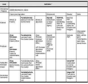
4.2 INSTITUTIONS
Government institutions concerned with the prevention and suppression of land and forest fires (PPKHL) are :
The Forestry Sector, i.e.: the Ministry of Forestry
The Agricultural Sector, i.e.: the Ministry of Agriculture
The Environmental Sector, i.e.: State Ministry for the Environment
The Disaster Management Sector, i.e.: Bakornas PBP
Other sectors, i.e.: the Ministry of Home Affairs, BMG, LAPAN, BPPT
A. The Forestry Sector
A large proportion of the fires which occur in forest areas are related to forest exploitation, the use of land by the community, and other land conversion activities.
1. Ministry of Forestry
Development of Fire Control Systems, the Sub Directorate for Detection and Evaluation, the Sub Directorate for Prevention and Suppression, and the Sub Directorate for Fire Impact.
At the regional level, the problem of fire is generally tackled by the provincial and district Forestry Agencies.
2. The National Forest Fire Control Centre (PUSDALKARHUTNAS)
PUSDALKARHUTNAS is a non-structural organisation formed by the Ministry of Forestry specifically to handle the problem of fire. Through this organisation, it is hoped that the forest fire problem can be tackled in a comprehensive manner, that official coordination can be more easily facilitated among sections in the Ministry and among related institutions at provincial and district level throughout Indonesia. PUSDALKARHUTNAS is headed by the Director General for Forest Protection and Nature Conservation; members are the Secretary General and all the other director generals in the Ministry of Forestry, the Board of Directors of the State owned Forestry Company, Ministerial Technical Advisor VI and the Indonesian Association of Forest Enterpreneurs (APHI). The main duties and functions of PUSDALKARHUTNAS are :
Formulate and give direction on operational policy concerning the prevention and suppression of forest
Coordinate efforts to prevent and extinguish forest fires in an integrated manner at national level.
Supervise the implementation of programmes within the framework of operational policy determined by the minister
Plan the methods and equipment required to bring forest fires under control
30
Box 8
Industrial Forest and Oil Palm Plantations Catch Fire
Jambi, Kompas – As of Thursday afternoon (12/6/2003), approximately 1,000 hectares of Jelutung industrial forest (HTI) belonging to PT Diera Hutani Lestari (DHL) had been destroyed by fire. The HTI, which is owned jointly by PT DHL and PT Inhutani V, is located in Kecamatan Kumpeh Hilir, Kabupaten Muaro Jambi, in the Province of Jambi.
Despite the efforts of the fully equipped team of firefighters sent by the Land and Forest Fire Control Centre for Jambi (Pusdalkarhutla), the fire rapidly spread and raged out of control. The fire has been burning since last Monday.
In addition, fire is also raging through oil palm plantation belonging to PT Bahari Gembira Ria (BGR) in Sungaigelam, Muaro Jambi. Here also, efforts to control the fire have so far failed. A team of firefighters from Pusdalkarhutla, together with transmigrants and PT BGR’s own firefighters are all working hard to bring the fire under control and extinguish it.
Forestry Minister’s decree No.97/Kpts-II/1998 assigns responsibility for tackling fire to the Land and Forest Fire Control Centre (PUSDALKARHUTLA) at provincial level, to the Commando Post for Land and Forest Fire Control (POSKOLAKDALKARHUTLA) at District (Kabupaten) level, and to theLand and Forest Fire Control Implementation Unit (SATLAKDALKARHUTLA) at local (Kecamatan) level.
The General Chairman of the PUSDALKARHUTLA Fire Control Centre is the Governor, with the Head of the Provincial Forestry Office as his deputy, while the Head of the District (Kabupaten) Forestry Office is responsible for the day-to-day running of the centre, assisted by representatives from related institutions as his deputies.