@2012 Puslit Geoteknologi
Lembaga Ilmu Pengetahuan Indonesia 11
NEW GEOCHEMICAL DATA OF ISLAND-ARC ORIGIN FOR
SUMATERA: THE BENGKULU CASE.
Data Geokimia Baru Asal Mula Busur Kepulauan Untuk Sumatera:
Kasus Bengkulu
Iskandar Zulkarnain
ABSTRACT
Sumatera is always recognized as margin of Eurasia continental plate, where the Indian oceanic plate is considered to be subducted beneath continental materials. The subduction system has produced volcanic or magmatic rocks on Sumatera at least since Cretaceous. Chemical analytical results of volcanic rocks in Bengkulu Province on major, trace and rare earth elements reveal that the volcanic rocks are derived from two different tectonic settings where the western side showing island-arc character and the eastern side represents an active continental margin (ACM). The island-arc group is characterized by lower ratio of (Ce/P)N varying between 1.1 to 2.4 andwider range of (P/Zr)N ratio varying from 1.0 to
1.7, while the ACM group show wider variation with (Ce/P)N ratio more than 3.4 and has narrower
range of (P/Zr)N ranging from 0.3 to 0.6. The REE
pattern of the island-arc in spider diagram shows steady decreasing in rock/chondrite ratio from La to Lu, while the ACM type is characterized by flat trend from Eu to Lu. The results suggest that it is not the whole Sumatera showing continent character, but it is island-arc in origin from Sumatera Fault Zone to the west and becomes ACM to the east.
Keywords: Sumatera, Island-Arc origin, Active Continental Margin, Geochemical Data, REE
Naskah masuk : 12 Maret 2012 Naskah diterima : 11 Mei 2012
Iskandar Zulkarnain
Pusat Penelitian Geoteknologi – LIPI Jl. Sangkuriang Bandung 40135 E-mail : [email protected]
ABSTRAK
Sumatera selalu dilihat sebagaitepian lempeng Eurasia, tempat lempeng samudera Hindia dianggap menunjam di bawah material benua. Sistem penunjaman tersebut telah menghasilkan batuan-batuan volkanik atau magmatik di pulau Sumatera, setidaknya sejak Zaman Kapur. Hasil analisis kimia unsur-unsur utama, jejak dan tanah jarang (REE) pada batuan-batuan volkanik di Provinsi Bengkulu telah mengungkap bahwa batuan-batuan volkanik tersebut berasal dari dua lingkungan tektonik yang berbeda, yakni di sebelah barat menunjukkan karakter busur kepulauan dan di sebelah timur mewakili lingkungan tepian benua aktif (ACM). Kelompok busur kepulauan dicirikan oleh rasio (Ce/P)N yang rendah, berkisar antara 1.1 hingga kepulauan dalam diagram laba-labanya menunjukkan tren penurunan rasio rock/chondrite yang konstan dari La ke Lu, sedangkan kelompok ACM dicirikan oleh tren yang mendatar dari Eu ke Lu. Hasil-hasil tersebut menunjukkan bahwa tidak seluruh Sumatera memiliki karakter benua, tetapi ia bersifat busur kepulauan dari Patahan Sumatera ke barat dan berubah menjadi tepian benua aktif ke timur.
Kata Kunci: Sumatera, asal mula Busur
Kepulauan, batas kontinen aktif, data Geokimia, unsur tanah jarang
INTRODUCTION
12
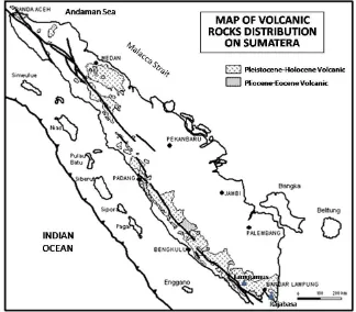
Figure 1. Distribution of volcanic on Sumatera that mostly concentrated along the west coast of the island with exception in Lampung and North Sumatera Provinces (after Zulkarnain, 2007).
setting (Hamilton, 1979; Curray, 1989; Barber, 2000; Barber and Crow, 2003; Crow, 2005). All researchers also agree that there is an oblique subducted Indian Ocean plate beneath the continental plate of Sumatera along the western coast of the island. The subduction zone system has controlled the formation of volcanic chains along the western part of the island. The volcanic activities along the western coast of the island has been traced since Pliocene indicated by distribution of volcanic rocks along the area with various age younger than Pliocene (Figure 1).
All of the volcanic rocks are interpreted to be derived from magma sources resulted by partial melting of subducted oceanic slab penetrating continental material during their ascend (Tatsumi and Eggin, 1995). Therefore, their geochemical signatures should reflect active continental margin (ACM) characters.
The understanding is used also to describe or to figure many geological aspects on the island such as the genesis of gold mineralization along the west flank of Bukit Barisan Mountain or mechanism controlling the formation of volcanic
chains along the west side of the island and also tectonic history of the island. The understanding also becomes a basic frame in revealing potential earthquake hazard in the area and it is valid since decades.
The new data from Lampung Province reveal that volcanic rocks in the province show two different tectonic origins where the western side represents island-arc character and then change to ACM type towards the eastern side (Zulkarnain, 2011). The aim of this paper is to get confirmation about the pattern in Bengkulu Province for strengthening the new tectonic understanding that Sumatera consists of two different segments where the western segment is island-arc in origin, while the eastern segment belongs to the margin of Eurasia Continent.
Geological Setting
@2012 Puslit Geoteknologi
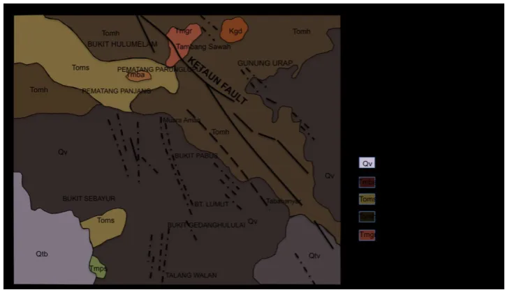
Lembaga Ilmu Pengetahuan Indonesia 13 Figure 3. Sample location map showing western and eastern side of the province.
Figure 2. Geological map of the Bengkulu area in which the samples were collected (after Gafoer et al., 1992).
Lumut and Hulusimpang Formation. In the NW of the map, the area is covered by Seblat Formation. Several intrusions having composition granodiorite and granite penetrated the Hulusimpang Formation.
According to Gafoer et al. (1992), The Hulusimpang Formation was deposited during Last Oligocene to Pre-Miocene consisting of lava, volcanic breccia, and tuff. Interfingering with the Hulusimpang Formation, the Seblat Formation was also deposited and it is composed of sandstone containing silicified wood and intercalation with
14
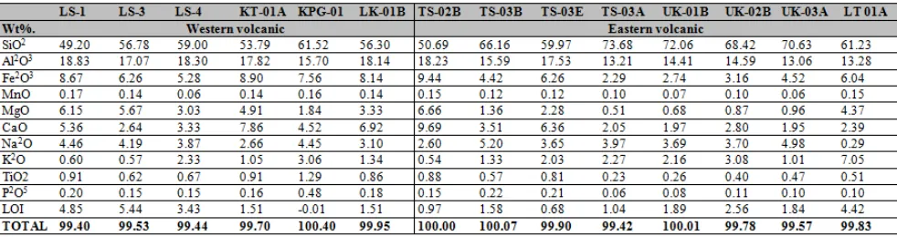
Table 1. Major elements composition of the western- and eastern volcanic rocks from Bengkulu Province Sample Location and Analytical Method
Around 30 relatively fresh rock samples were collected from the western and eastern sides of the Bengkulu Province and fourteen of them were analyzed for major, trace and rare earth elements. The chemical analysis was done by Activation Laboratories in Canada under analysis code 4Litho. They have developed a lithium metaborate/ tetraborate fusion ICP Whole Rock Package and a trace element ICP/MS package that is unique for scope of elements and detection limits. The two packages are combined for Code 4Litho and Code 4Lithoresearch.
Six samples were analyzed from the western side consisting of three samples collected in Air Ketaun (sample code LS), one sample from Siguring village (sample code KT), one sample from Sungai Pagu village (sample code KPG) and another sample from Lubuk Kembang village, near the two previous mentioned village (sample code LK). Eight samples were analyzed from the eastern side consisting of four samples collected around Tambang Sawah village (sample code TS), three samples from Ulu Ketenong village (sample code UK) and one sample from Lebong Tambang, near Muara Aman (sample code LT) (Figure 3).
RESULTS
Major Elements
14 samples were collected from the study area consisting of six samples from western part and eight samples from the eastern side. The western side samples consist of LS-1, LS-3, LS-4, KT-01A, KPG-01 and LK-01B, while the eastern side the western volcanic side and the eastern one. The volcanic rocks of the western side are dominated by more basic rocks than the eastern ones, where the western volcanic rocks are basaltic to dacitic in composition (49.20 to 61.52 %weight SiO2), while
the rocks from eastern side consist of basalt to granite (50.69 to 73.68 %weight of SiO2). The
different of the two volcanic types above is shown also by higher content of Al2O3 and TiO2 for
western side than the eastern ones, while the K2O
content of the western side rocks is lower than the eastern ones. The analytical result shows that three samples of the western volcanic rocks (LS-1, LS-3 and LS-4) and one sample of the eastern ones (LT-01A) have been altered partly indicated by relative higher LOI content. Probably, they are influenced by some hydrothermal activities covering the area locally.
Generally, based on the composition, the volcanic rocks represent two different tectonic environments where the western side reflects island-arc origin and the eastern side shows more continental character.
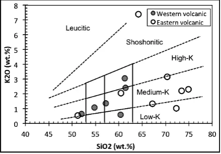
Plot all rocks in the SiO2 versus K2O correlation
diagram gives more clearly figure about the composition of the rocks. The western side consists of basalt, basaltic andesite and dacitic rocks and most of them reflect medium-K character (Figure 4). One sample (LS-3) shows low-K character and another sample (KPG-01) belongs to high-K character. The low-K sample originally should belong also to medium-K group because based on its higher LOI content, probably some of its K2O content has been removed from
@2012 Puslit Geoteknologi
Lembaga Ilmu Pengetahuan Indonesia 15 Figure 4. Plot of the Bengkulu volcanic rocks in
the SiO2 versus K2O diagram showing two different group characters (after Le Bass et al., 1986).
Figure 5. Distribution of the Bengkulu volcanic rocks showing calc-alkaline affinity (after Miyashiro, 1974).
Figure 6. Distribution Bengkulu volcanic rocks in Zr versus Y diagram classifies all rocks as transitional type.
The high-K sample should have different character than the other rocks in the western side.
Meanwhile, the eastern volcanic rocks shows wider rock composition from basalt to granite but they are dominated by acidic or granitic rocks. Most of them also belong to medium-K group but one sample (UK-03A) shows low-K character and another sample (LT-01A) is located extremely in the area between shoshonitic and leucitic. The sample with extreme K2O content (LT-01A) has
been already altered and the alteration seems to be responsible for enrichment on K2O. In this case,
the rock was suffered K-metasomatism where significant amount of its Na2O had been removed
from the rock and substituted by K2O coming from
hydrothermal fluids that influenced the area.
Even though the rocks can be clearly distinguished into two different groups, but generally the rocks show similar affinity, namely calc-alkaline (Figure 5). Most of the western volcanic rocks show calc-alkaline character, but one sample lies in the field of tholeiitic near to the boundary.
This sample contains higher potassium than others in western side and classified as high-K group (Figure 4).
It looks like that the sample is different from others in western side because it is depleted significantly on Magnesium and relatively enriched on Iron. This phenomenon does not occur in term of metasomatism process due to fresh rock condition reflected by very low LoI content. Meanwhile, all volcanic rocks of eastern side completely belong to calc-alkaline affinity in a clear trend and in a narrow cluster. But one of the samples shows low
ratio of FeO*/MgO at 64% SiO2. This sample
contains relatively high Magnesium but also significant high on Potassium.
It seems that the high MgO content of this sample is also related to metasomatism process causing its high K2O content. In this case, the sample was
probably firstly influenced by K-metasomatism that replaced Natrium in plagioclase or feldspar. The breakdown of the plagioclase or feldspar will remove Ca and Aluminium partly from the rock. The removing of Aluminium from the rock has been probably replaced by Magnesium through metasomatism or alteration process that leads to increasing of MgO content in the rock.
16
Table 2. Trace elements analytical results of Bengkulu volcanic rocks.
Figure 7.. Pattern of Bengkulu western side volcanic rocks showing similarity with island-arc basalt. (Wilson IAB data are taken from Wilson, 1989)
Trace Elements
The 14 rock samples from Bengkulu area were analyzed also for trace elements, and the analytical result is given in the Table 2 below.
The difference between western side volcanic rocks and eastern side ones can be recognized also in their trace elements content. Generally, the eastern side volcanic rocks contain higher Potassium, Yttrium and Tantalum (except sample TS-02B and UK-03A) than the western ones, but they are lower on Phosphate, Titanium and Strontium. To get their pattern in spider diagram, the trace elements content is normalized to MORB according to Pearce (1983). The pattern of island-arc spider diagram is characterized by depletion on Ta, Nb, Zr and Hf compared to MORB (Wilson, 1989) and the Bengkulu volcanic rocks show these characters in the western side (Figure 7 and 8). Their pattern is similar to island-arc basalt but their Ce and P content is lower than the island-arc basalt. Beside that, the enrichment on Sm recognized in the island-arc basalt compared to MORB has not been found in the western side of Bengkulu volcanic rocks, because their Sm content is almost always similar to MORB. Generally, it shows that the western side Bengkulu island-arc volcanic rocks are characterized by lower content Ce, P and Sm than island-arc basalt. One of the samples (KPG-01) shows higher Ta and Nb and even on other compatible elements (such as Ce, P, Zr and Hf) compared to MORB (Figure 8), but it
shows clearly similar pattern with the island-arc basalt. Of course, it is not exactly represented island-arc products, but its similar pattern indicates that it is island-arc in origin. Therefore, the pattern classifies all of the western side volcanic rocks in Bengkulu as island-arc in origin.
island-@2012 Puslit Geoteknologi
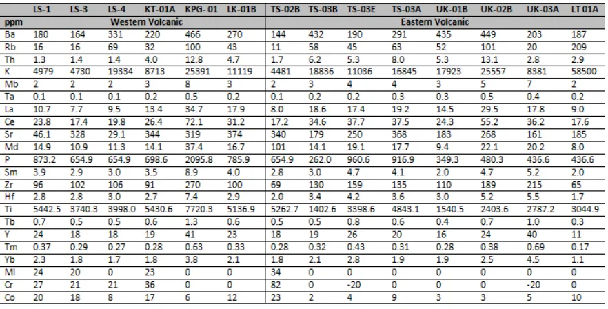
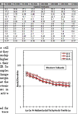
Lembaga Ilmu Pengetahuan Indonesia 17 Figure 9. Trace elements spider diagram of four
Bengkulu eastern side volcanic samples showing island-arc character. Figure 8. Pattern of Bengkulu western side
volcanic rocks showing also similarity with island-arc basalt.
Figure 10.. Trace elements spider diagram of four Bengkulu eastern side volcanic rocks showing ACM pattern (data for Wilson ACM line taken from Wilson, 1989).
arc pattern (Figure 9), while the other four samples represent active continental margin (ACM) pattern (Figure 10).
The above spider diagram shows that two of four samples (TS-02B and LT-01A) reflect depletion on Ta, Nb, Zr and Hf compared to MORB and they
should be derived from island-arc tectonic setting, even though they are also depleted on Sm and other compatible elements (Ti, Y and Yb) compared to MORB. The sample TS-02B shows lower concentration on incompatible elements (Sr, K, Rb, Ba and Th) than the island-arc basalt but with similar pattern (increasing trend from Sr to Th). But, sample LT-01A shows highly enrichment on K, Rb and Th, but its pattern is still similar with the previous ones. The other two samples (TS-03B and TS-03E) have been enriched on all incompatible and compatible elements, except for Ti, Y and Yb. However, they reflect good similarity in their pattern with island-arc basalt, except only on Sm content, like the western side samples. Therefore, it can be believed that the four samples of the eastern side volcanic rocks are derived from island-arc tectonic setting or they are island-arc in origin.
18
Table 3. Rare Earth Elements (REE) analytical results of Bengkulu volcanic rocks.
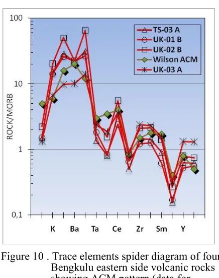
Figure 11. REE spider diagram of three samples from western side of Bengkulu area showing island-arc character. In this case, the samples from eastern side still
show island-arc pattern on Ta-Nb relation, but they show exactly similar pattern on P-Zr relationship with ACM where their Zr-content is much higher than the P. The other similarity with ACM is their significant depletion on Ti compared to MORB. So generallyit can be interpreted that the four samples are derived from transition condition that change from island-arc to active continental margin tectonic setting. Geographically, it shows that the Bengkulu area consists of two different tectonic setting where the western side is island-arc in origin while the eastern side becomes active continental margin.
Rare Earth Elements
Two different tectonic settings are recognized for the Bengkulu area based on major and trace elements of the western and eastern side volcanic rocks. The western side samples reflect island-arc origin, while the eastern sides ones show island-arc and active continental margin character. To confirm this result, the rare earth elements are considered to be important to analyse.
All of 14 volcanic samples from western and eastern side of Bengkulu were analyzed also for Rare Earth Elements (REE). The analytical result is given in the Table 3 below.
All of the REE elements above are normalized to chondrite and plotted in REE spider diagrams. Three samples from western side volcanic rocks show clearly island-arc pattern with slightly enrichment on incompatible elements and decreasing steadily with moderate dip to compatible elements (Figure 11).
Three other samples of western side volcanic rocks show similar pattern with the three previous
samples, but they are more enriched on incompatible elements and one of them (KPG-01) is also enriched on compatible elements (Figure 12). The last sample shows also a small trough at Eu indicating the influence of plagioclase crystallization during their magmatic history. This sample is believed to be derived from more fractionated magma source.
@2012 Puslit Geoteknologi
Lembaga Ilmu Pengetahuan Indonesia 19 Figure 12.. REE pattern of three other samples
from western side showing similar pattern to island-arc type with enrichment on incompatible elements.
Figure 13.. REE spider diagram of two samples from eastern side showing island-arc type where the LT-01A sample is considered to be derived from the most primitive magma in this region.
Figure 14.. REE spider diagram of two other samples from eastern side showing island-arc type with enrichment on incompatible elements.
Even, one sample (LT-01A) is more depleted on compatible elements compared to MORB (Figure 13). This sample represents probably the primitive island-arc magma in this region.
Generally, the four samples from the eastern side show enrichment on incompatible elements, varying from 40 to more than 80 times of chondrite and show steady decreasing to compatible elements and the trend becomes almost flat from Ho to Luelements. This pattern represents the pattern of REE spider diagram of volcanic rocks in island-arc origin. These REE patterns confirm the pattern in trace elements spider diagrams, even in each sample.
The other four samples from eastern side (TS-03A, UK-01B, UK-02B and UK-03A) show different pattern than the other above four samples. The pattern is characterized by significant enrichment on incompatible elements and then showing steep trend towards Eu element and then become flat from Eu towards Lu elements (Figure 15).
Based on comparison to their trace elements patterns, it can be interpreted that this pattern is the typical REE spider diagram for active continental margin product.
All samples show a trough at Eu (except sample UK-01B) indicating the role of plagioclase
20
Figure 15.. REE spider diagram of four samples from eastern side showing active continental margin (ACM) type. other samples showing more enrichment on
incompatible and compatible elements are derived from more fractionated phases of the primitive magma.
DISCUSSION
Composition range in major elements of the Bengkulu volcanic rocks classifies the rocks into two clusters. One represents a group with SiO2
content varying from 52 to 62 %weight (after normalized the analytical result without LoI) and the other group dominates by SiO2 ranging from 61
to 75 %weight (Figure 4). The first group is the western side of volcanic rocks and the second group is the eastern side ones. Based on the major elements, the western side represents the island-arc origin due to their products varying from basalt through basaltic andesite to dacitic in composition. In other side, the eastern side reflects more continental character due to their products ranging from dacitic to granitic in composition.
The above indication representing two clusters with different tectonic origin in Bengkulu areais confirmed by spider diagrams of their selective trace elements, but they show island-arc character in the western side and island-arc and ACM characters in the eastern side. All samples of western side show similar pattern with island-arc pattern in their selective trace elements, but they have lower Sm content than the island-arc type (Figure 7 and 8). In contrast, the eastern side samples instead reflect only ACM environment, they represent two tectonic origins distinguishing into island-arc and ACM tectonic settings. Four samples of the eastern side volcanic rocks have similar pattern with the island-arc type (Figure 9). All these four samples were collected from areas located in the western part of the eastern side volcanic rocks. Probably, they are derived from same magma sources with the western side volcanic rocks. Meanwhile, the other four samples collected from the eastern part of the eastern side volcanic rocks show similar pattern with the ACM type, characterized by higher Zr and Hf than P and significant depletion on Ti (Figure 10).
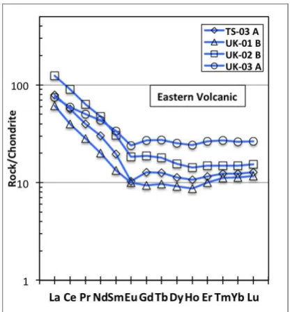
In term of REE, the existing of the two tectonic environments are also confirmed and the patterns reflecting in selective trace elements spider diagrams of all rocks are fully proper with those in REE spider diagrams. All samples from western side represent the island-arc character with various
degree of fractionation (Figure 11 and 12). Four samples of eastern side show also the island-arc character and with various stages of magmatic fractionation too (Figure 13 and 14), while the other four samples of the eastern side volcanic rocks represent ACM character (Figure 15).
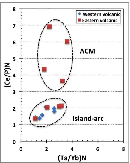
In order to get more clear separation between the two different tectonic settings, all rocks are plotted in the (Ta/Yb)N versus (Ce/P)N. The elements are
@2012 Puslit Geoteknologi
Lembaga Ilmu Pengetahuan Indonesia 21 Figure 16.. Plot all Bengkulu volcanic rocks in
(Ta/Yb)N versus (Ce/P)N correlation
diagram showing clearly separation of island-arc and ACM characters.
Figure 17... Plot all Bengkulu volcanic rocks in (Ta/Nb)N versus (P/Zr)N correlation
diagram showing clearly separation of island-arc and ACM rocks. All of western side volcanic rocks and four
samples of eastern side ones are classified as island-arc type, while the other four samples of eastern side volcanic rocks are grouped as ACM type. The island-arc group is characterized by lower ratio of (Ce/P)N varying between 1.1 to 2.4,
while the ACM group show wider variation with (Ce/P)N ratio more than 3.4. It means that the
island-arc magma contain higher Phosphate than the ACM ones. The island-arc group is concentrated in a narrow cluster area reflecting more homogeneous magma sources and small influences from its surrounding, while the ACM group shows significant influences from its surrounding leading to wider variation in their magma composition. It is also clearly can be recognized that they contain wide variation in Phosphate element reflecting dynamic movement (in and out) of that element through their interaction during magma ascend.
One of the important keys to distinguish between the island-arc volcanic rocks and ACM rocks is the comparison of P and Zr content, especially after normalized them to MORB (see Figure 7, 8, 9 and 10). It is clearly recognized that Zr content of the ACM volcanic rocks are higher than the island-arc
ones. It means, that the variation of P/Zr ratio in the ACM volcanic rocks will be narrower than that of the island-arc ones.
Plot of all Bengkulu volcanic rocks in the diagram of (Ta/Nb)N versus (P/Zr)N shows also clear
separation between the island-arc and ACM groups (Figure 17). The island-arc group is characterized by wider range of (P/Zr)N ratio varying from 1.0 to
1.7, while the ACM group has narrower range of (P/Zr)N ranging from 0.3 to 0.6. In contrast, the
ACM group shows wider range in (Ta/Nb)N ratio
than the island-arc one reflecting lower content on Nb.
In line with the plot result of the Bengkulu volcanic rocks in the Figure 16, the plot of the rocks in the Figure 17 is exactly confirmed that all volcanic rocks from western side and four samples from eastern side are classified as island-arc origin, while the other four samples from eastern side are identified as ACM origin.
22
margin but island-arc in origin. That is why the assumption that all Sumatera Island belongs to the margin of Eurasia continental plate should be corrected. This new perspective will influence all established concepts for resources potentiality in the western flank of Bukit Barisan Mountain in western part of Sumatera.
CONCLUSION
Based on all above discussions, it can be concluded that the western side of Bengkulu area is island-arc in origin, while the eastern side of the area belongs to active continental margin (ACM). The borderline of the two different tectonic settings looks like to be located along a lineation passing area around the Tambang Sawah village in Rejang Regency. This evidence reveals that the Lampung Provinces (located in south of Bengkulu Province) indicating that western part of Lampung Province is island-arc in origin, while the eastern part shows ACM character (Zulkarnain, 2011). It means, the judgment assuming for western coast of Sumatera Island, as the margin of Eurasia Continent cannot be longer useable. Of course, it is needed more geochemical evidences from volcanic rocks along west coast of the island towards the north from Bengkulu, to confirm this conclusion.
Acknowledgment
This paper is written based on research that was conducted in Research Center for Geotechnology (RCG), Indonesian Institute of Sciences that financed through the National Budget of the Republic of Indonesia. The research focus on volcanic rocks covered the Sumatera Island from the most southern province (Lampung Province) up to North Sumatera Province. The fieldwork and sample preparation were carried out by researchers in Hydrothermal Mineral Deposit Research Group in RCG into which I belong to. I thank so much to all colleagues in the Research Group for nice collaboration and supports during fieldwork and sample preparation activities.
References
Barber, A.J., 2000, The origin of the Woyla Terranes in Sumatra and the Late Mesozoic evolution of the Sundaland margin, Journal of Asian Earth Sciences, 18, 713–738
Barber, A.J. & Crow, M.J., 2003, Evaluation of plate tectonic models for the development of Sumatera, Gondwana Research, vol. 20, 1-28
Barrett, T.J. and MacLean, W.H., 1999,Volcanic sequences, lithogeochemistry, and hydrothermal alteration in some bimodal volcanic-associatedmassive sulfide systems
In: Volcanic-Associated Massive Sulfide Systems: Processes and Examples in Modern and Ancient Settings (C.T. Barrie and M.D. Hannington, editors), Reviews in Economic Geology, v.8, 101-131
Crow M.J., 2005, Pre-Tertiary volcanic rocks, In: Barber, A.J., Crow, M.J & Milsom, J.S., 2005, Sumatra: Geology, Resources and Tectonic Evolution, The Geological Society, London
Curray, J.R., 1989, The Sunda Arc: a model for oblique plate convergence, Netherlands Journal of Sea Research, vol.24, 131-140 Gafoer, S., Amin, T.C., and Pardede., 1992,
Geological map of Indonesia, Bengkulu sheet, Geological Research and Development Centre, Bandung
Hamilton, W., 1979, Tectonics of the Indonesian region, U.S. Geological Survey Prof. Paper 1078.
Le Bas, M. J., Le Maitre, R. W., Streckeisen, A. and Zanettin, B., 1986, A chemical classification of volcanic rocks based on the total alkali–silica diagram, Journal of Petrology, vol.27, 745–750.
Miyashiro, A., 1974, Volcanic rockseries in island-arcs and active continental margins, American Journal of Science, vol.274, 321–355
Pearce, J.A., 1983, The role of sub-continental lithosphere in magma genesis at destructive plate margins. In Hawkesworth, C.J. & Norry, M.J. (eds),
@2012 Puslit Geoteknologi
Lembaga Ilmu Pengetahuan Indonesia 23 Tatsumi, Y. and Eggins, S., 1995, Subduction
zonemagmatism, Blackwell Science, Frontiers in Earth Sciences, 211pp, ISBN 0-86542-361-X
Wilson, M., 1989, Igneous Petrogenesis; a global tectonic approach, Unwin Hyman, London, 466pp
Zulkarnain, I., 2007, Geochemical character of Hulusimpang Formation volcanic around
Kota Agung area and their genetic implication, Jurnal JTM international edition, vol. XIV, No.3, 156-167