MEASURING WATER CONFLICT POTENTIAL : A BASIC PRINCIPLES
Purwanti Sri Pudyastuti*, Jaji Abdurrosyid **
ABSTRACT
Decentralisation has been implemented in Indonesia for several years based on Regulation No. 22/1999 about decentralisation. In fact, decentralisation system is better than centralisation. However, there are some constraint in the implementation of decentralisation in Indonesia, therefore, the result of the decentralisation implementation is not as expected. The constraint of the implementetion of decentralisation in Indonesia are, for examples, limited skilled and qualified human resources, lack of coordination, lack of information about thedecentralisation regulation, and limited natural resources for each different region. There is a report that some conflicts have been arising between some regions due to water dispute, for examples, water dispute between PDAM Surakarta and Boyolali Regency Government. Besides that, there might have been some water disputes in Indonesia, but not been widely informed yet. According to some researches and reports, there are some important indicators that can be used in measuring water conflict potential, such as Index of Human Insecurity (IHI), Water Stress Index (WSI), and Social Water Stress Index (SWSI). In addition, there are some important data required to measure these indicators, such as population number,volume of runoff , number and density of dams, minority community group, GDP, inter regions relationship condition, and number of agreement about fresh water management.
.
Key words : decentralisation, water resources management, water conflict potential, water conflict indicator.
INTRODUCTION
Decentralisation has been implemented in
Indonesia for several years, however some problems
has been faced related to its implementation due to
some matters such as lack of coordination, lack of
qualified human resources, inadequate regulations,
and the fact that each region have different natural
resources. In addition, decentralisation also gives
impact on water sector which lead to conflict
between regions. In addition, in Indonesia, there are
many rivers which flow between different regions
and many transboundary river basins, such as
Bengawan Solo river basin which is located from the
south-west of Central Java Province to the north-east
of East Java Province, and passes through 9
regencies/municipalities in Central Java Province
and 11 regencies/municipalities in East Java Province
(Jasatirta, 2003). Due to some matters such as lack of
coordination among stakeholders in managing water
resources, conflict over water between regions is
likely to happen.
Therefore, measuring water conflict potential is
important as information required to anticipate and
reduce water dispute in the future.
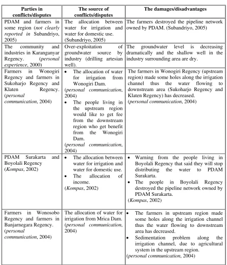
RECENT WATER DISPUTES IN INDONESIA
According to some news paper report and other
sources, there have been some water conflicts happen
in Indonesia. The table below shows some examples
of water conflicts in Central Java Province.
The water disputes shown on the table above are
only such problems that happen in Central Java
Province. Indonesia is a big country, and there must
be other water disputes happened in other regions due
to, for instance, the increasing of population growth
and water uses competition. However, it might not be
widely informed yet. Hence, emphasis should be
done to anticipate and reduce the conflict over water.
MEASURING WATER CONFLICT
POTENTIAL
According to Votrin (2003), there are some water
conflict indicators that can be used to measure the
potential of water conflict, for instance :
1.
Index of Human Insecurity (IHI). This indicator
is developed to facilitate identification of
vulnerable regions. Index of Human Insecurity is
defined as “
an aggregate measure of human
welfare that integrates social, economic, and
political exposures to and capacity to cope with a
range of potentially harmful perturbations
”.
Votrin (2003) reported that the IHI identifies four
“key system components”, namely : the
environment, the economy, society, and
institutions. .
* Purwanti Sri Pudyastuti, staf pengajar jurusan Teknik Sipil - Universitas Muhammadiyah Surakarta, Jl. A. Yani No.1 Tromol Pos 1, Pabelan Kartasura Surakarta 57102. E-mail : [email protected] ** Jaji Abdurrosyid, staf pengajar jurusan Teknik Sipil - Universitas Muhammadiyah Surakarta,
Measuring Water Conflict Potensial : A Basic Principles
...(Purwanti Sri P., Jaji AR.)
102
Table 1. Some examples of water conflicts in Central Java Province
Parties in
conflicts/disputes
The source of
conflicts/disputes
The damages/disadvantages
PDAM and farmers in
some region (
not clearly
reported in
Subandriyo,
2005)
The allocation between
water for irrigation and
water for domestic use.
(Subandriyo, 2005)
The farmers destroyed the pipeline network
owned by PDAM. (Subandriyo, 2005)
The community and
industries in Karanganyar
Regency. (
personal
experience
, 2000)
Over-exploitation of
groundwater source by
industry (drilling artesian
well).
The groundwater level is decreasing
dramatically and the shallow well in the
industry surrounding area are dry.
Farmers in Wonogiri
Regency and farmers in
Sukoharjo Regency and
Klaten Regency.
(
personal
communication
, 2004)
•
The allocation of water
for irrigation from
Wonogiri Dam.
(
personal communication
,
2004)
•
The people living in
the upstream region
would like to get fee
from the downstream
region who get benefit
from the Wonogiri
Dam.
(
personal communication
,
2004)
The farmers in Wonogiri Regency (upstream
region) made some holes along the irrigation
channel thus the water flowing to
downstream area (Sukoharjo Regency and
Klaten Regency) has decreased.
(
personal communication
, 2004)
PDAM Surakarta and
Boyolali Regency
(
Kompas
, 2002)
•
The allocation between
water for irrigation and
water for domestic use.
•
The allocation of
income.
(
Kompas
, 2002)
•
Warning from the people living in
Boyolali Regency that said they will stop
distributing the water to PDAM
Surakarta.
•
The people in Boyolali Regency
destroyed the pipeline network owned by
PDAM Surakarta.
(
Kompas
, 2002)
Farmers in Wonosobo
Regency and farmers in
Banjarnegara Regency.
(
personal
communication
, 2004)
The allocation of water for
irrigation from Mrica Dam.
(
personal communication
,
2004)
•
The farmers in upstream region made
some holes along the irrigation channel
thus the water flowing to downstream
area has decreased.
•
Sedimentation problem along the
irrigation channel, due to agricultural
system in the upstream region.
(
personal communication
, 2004)
(source : cited from Pudyastuti, 2005)
Within each of these four indicator categories are
four variables, each of which measure either a
key structural relationship (e.g., linkages,
defining characteristics) or a key functional
relationship (e.g., processes, flows) of the
system. Where data in a time series are missing,
IHI developers utilize statistical techniques to
establish a complete time series for all indicators
and all countries, where there is sufficient initial
data. However, the index for each year is specific
to that year, making it difficult to compare
changes in a country’s IHI from across years.
2. Water Stress Index (WSI). The formulae to
population
of
number
available
resources
water
of
volume
WSI
=
However, this measure does not account for a
country’s ability to adapt to water stress, such as with
more efficient irrigation technology.
3. Social Water Stress Index (SWSI). The SWSI has
developed to incorporate a measure of country’s
adaptability. The formulae to calculate SWSI is :
2
/
'
s
Human
Developmen
t
Index
UNDP
WSI
SWSI
=
Besides the three indicators described above,
there are several other potential indicators were also
mentioned in the literature, including overall
population growth rates within a country, population
density within and outside a basin, relative power and
riparian position of countries within a basin (Wolf,
1999, cited in Votrin, 2003), the degree of
democratisation of countries sharing a river basin, per
capita GDP, etc..
DATA REQUIRED IN MEASURING WATER
CONFLICT POTENTIAL
According to Votrin (2003), there are some
important data required to measure the potential of
water conflict, such as :
•
Population
. Population growth is one of the key
factors to assess water scarcity. The relation of
water access to population distribution should
therefore be assessed. In measuring water
conflict potential, the evaluation of river basin
population density is preferably to be done
instead of the evaluation of region population
density, because a river basin rarely follows
political or administrative boundary.
•
Runoff
. Runoff is defined as the total amount of
surface flow in a given area. Votrin (2003) noted
that any assessment of a water resource related
issue would be incomplete without some
approximation of water availability within the
study area.
•
Dams
. The number and density of dams in a
study area is one of the key factors in assessing
water scarcity (Votrin, 2003). Furthermore,
Votrin (2003) noted that when statistically testing
potential water conflict indicators, dams
themselves did not appear to be a potential
indicator for water conflict, yet in basins without
water treaties lower dam density basins tended to
exhibit slightly less conflict. With negative
overall relations between countries and absence
of a transboundary institution, unilaterally setting
a large dam or diversion project can provide a
context for the conflict over water, while positive
relations and presence of a transboundary
institution can mitigate the situation.
•
Minority groups
. Minority groups such as people
displaced from dam construction site might cause
conflict.
•
GDP (Gross Domestic Product)
. Low per capita
GDP (< $765/person according to the World
Bank lowest income country definition) was
identified to be one of the indicators of conflict
over water (Yoffe, 2001, cited from Votrin,
2003).
•
Overall relations
. Generally speaking, regions
that co-operate in general also co-operate over
water, and regions with overall unfriendly
relations are also unfriendly over water issues.
•
Freshwater treaties
. Votrin (2003) reported that
generally, freshwater treaties mitigate conflict,
and no or limited freshwater treaties for a basin
increase the likeliness of conflict over water.
TESTING INDICATOR OF WATER
CONFLICTS
Votrin (2003) reported that the methodology for
establishing indicators of international freshwater
conflict and co-operation was developed under
Basins At Risk (BAR) project at Oregon State
University, USA (Wolf, Yoffe and Giordano, 2003,
cited from Votrin, 2003). BAR which has spanned
for 4 years effectively developed and created legal
and spatial framework to further evaluate
international river basins at potential risk for future
water conflict.
Furthermore, Votrin (2003) noted that indicators
could be selected in accordance with the following
criteria: relevance to the selected framework; general
availability of the data; existence of a theoretical or
empirical link with security issue; and an adequacy of
spatial and temporal coverage allowing for effective
representation and modelling. Emphasis was made on
the regional and basin scale indicators rather than on
indicators of potential water conflict at global scale.
Internationalisation of a basin was at special focus.
Assuming that there is a causal link between the
internationalisation of a basin and incidents of
conflict among the states that now share that basin,
the presence of ethnic minorities with nationalistic
aspirations becomes a potential indicator (Wolf,
1999, cited from Votrin, 2003).
Measuring Water Conflict Potensial : A Basic Principles
...(Purwanti Sri P., Jaji AR.)
104
the relative strength of various independent variables
in explaining the variability of the event data. Also,
other statistical methods such as two-sample t-test
could be employed. Linear regression is preferably
chosen because “it offered a concise summary of the
mean of the response variable as a function of an
explanatory variable” (Yoffe, 2001, cited from
Votrin, 2003).
Furthermore, Votrin (2003) noted that most of
the commonly cited water conflict indicators proved
to be unsupported by the data. Neither government
type, climate, IHI, water stress or number of dams,
nor agricultural dependence on water resources and
energy needs showed a significant relevance with
water conflict. Based on the research done by Votrin
(2003), river basins are at potential risk of freshwater
conflict if, for instance:
•
population density exceeds 100 people per 1
km
2•
per capita GDP is less than $765
•
overall unfriendly relations (<-1 at water
event intensity scale)
•
there are politically active minority groups
that may lead to the internationalisation of a
basin
•
large dams or other water development
projects are planned
•
no or limited number of water treaties is
available
WATER CONFLICT POTENTIAL IN
INDONESIA
Indonesia is a big countries formed of thousands
islands with many transboundary river basins within
them. The population of Indonesia is about 250
millions people that is increasing rapidly annually.
Besides that, there are many big dams constructed in
all around Indonesia, therefore there are significant
number of displaced people due to the dams
construction that might be source of conflict.
Furthermore, the government do not pay attention to
the displaced people in the upstream region which
might lead to a conflict. In addition, according to
World Bank report, Indonesia per capita GDP is low.
Therefore, in the author opinion, Indonesia is at
potential risk of freshwater conflict. Furthermore,
research related to this problem should be done to
anticipate and reduce conflicts over water.
Water Law in Indonesia
According to Siswoko (2006), Republic of
Indonesia Water Law No. 7 / 2004 has regulated the
water resources management in whole Indonesia
including the management of transboundary river
basin and the resolution of conflict over water.
However, this regulation has not been correctly and
widely informed, and there are still some weaknesses
in this regulation particularly in transboundary water
resources management and conflict resolution. In
addition, Siswoko (2006) also reported that the
Indonesia Ministry of Public Work and Directorate
General of Water Resources Management has
arranged new regulation related to the management
of transboundary water resources and resolution of
conflict over water..
CONFLICT RESOLUTION IN
TRANSBOUNDARY RIVER BASIN
MANAGEMENT
According to Smout et al (2004, p. 286), the
methods used to resolve the conflict will depend on
the issues involved; if there is a dispute about facts,
then this can be addressed by investigating the
situation to ascertain the true picture. Differences in
understanding may be resolved through education
and communication, whilst differences in goals are
more fundamental. The first step therefore is to
identify the issues considered important by all the
stakeholders. Furthermore, the enabling environment
(legal and institutional) has an important role in
conflict resolution.
Smout et al (2004, p. 288) noted that there are
some techniques in conflict resolution processes, and
all these techniques rely on a process that involves :
(a) clarifying differences and points of disagreement,
(b) making a commitment to stakeholder
decision-making, (c) sharing knowledge, (d) recognising the
interdependence of water users, (e) promoting the
need for change building relationships, (f) changing
the viewpoints of all parties, so they can see and
accept the opposition’s situation, and (g) identifying
what is most important.
CONCLUSIONS AND RECOMMENDATIONS
Conclusions
According to the explanation above, it can be
concluded that :
1.
In fact, there have been some conflict over water
happened in Indonesia. However, emphasis has
not been done seriously to anticipate the conflict
over water in Indonesia.
2.
There are some key indicators to measure water
conflict, such as :
•
Index of Human Insecurity (IHI)
•
Water Stress Index (WSI)
3.
Some data is required to measure the water
conflict indicators, namely :
•
Population data
•
Runoff data
•
The number and density of dams
•
The existing of minority groups
•
Gross Domestic Product (GDP)
•
The existing overall condition among regions
•
Freshwater treaties
4.
The Republic of Indonesia Water Law No. 7 /
2004 is one of the enabling environment that can
be used as a guidance in resolution of conflict
over water happened in Indonesia.
Recommendations
The author would like to give several
recommendations related to the conflict over water in
Indonesia, namely :
1.
The Republic of Indonesia Water Law No. 7 /
2004 should be widely informed to the public. It
is not only informed to academic group, but also
informed to all stakeholders.
2.
Further research about water conflict potential
should be done as soon as possible because there
have been some evidence related to conflict over
water, therefore water conflict could be
anticipated and reduced immediately.
3.
Data base related to the measurement of water
conflict indicators should be set up in the whole
Indonesia regions.
REFERENCES
Jasatirta Wilayah I, 2003,
Wilayah Kerja Balai
Pengembangan Sumber Daya Air Propinsi Jawa
Tengah
, (downloaded from:
http://www.jasatirta1.go.id/
)
Kompas Newspaper, 1999,
Rebutan Sumber Air di
Pengging Boyolali
, 10 July 1999 edition.
(downloaded from :
http://www.kompas.com/kompas-cetak/9907/10/daerah/rebu17.htm
)
Pudyastuti, P.S., 2005,
Improving the Implementation
of Decentralisation in Water Sector in Central
Java Province, Indonesia
, Individual Project
Report (M.Sc dissertation), WEDC,
Loughborough University, United Kingdom.
Siswoko, 2006,
Pokok-pokok Kebijakan yang Diatur
Dalam Undang-Undang No. 7 Tahun 2004
Tentang Sumberdaya Air
, Paper presented on
National Conference on Civil Engineering Role
in Sustainable River Basin Management,
Universitas Sebelas Maret Surakarta.
Smout, I., Reed, B., Dijkstra, T. and Elson, B., 2004,
Integrated Water Resources Management
,
WEDC Postgraduate Module, Loughborough
University, UK.
Subandriyo, T., 2005,
Air dan Konflik Kepentingan
,
Suara Merdeka Newspaper (22 March 2005
edition), Semarang, Central Java. (downloaded
from :
http://www.suaramerdeka.com/harian/0503/22/op
i04.htm
)