EARTH OBSERVATION IN SUPPORT OF SCIENCE AND APPLICATIONS DEVELOPMENT IN THE FIELD “LAND AND ENVIRONMENT”: SYNTHESIS RESULTS FROM THE ESA-MOST DRAGON COOPERATION PROGRAMME
C. Cartalis a,*, D.N., Asimakopoulos b, Y. Ban c, Y. Bao d, Y. Bi e, P. Defourny f, G. Del Barrio g, J. Fan h, Z. Gao i, H. Gong j, J. Gong k, P. Gong l, C. Li m, S. Pignatti n, A. Sarris o, G.Yang p
a Department of Environmental Physics, University of Athens, Greece – [email protected] b Department of Environmental Physics, University of Athens, Greece – [email protected] c KTH Royal Institute of Technology, Sweden - [email protected]
d Inner Mongolia Normal University, China - [email protected] e University of Ulster, United Kingdom - [email protected]
f Universite Catholique de Louvain, Belgium - [email protected] g Estacion Experimental de Zonas Aridas (CSIC), Spain - [email protected] h National Satellite Meteorological Center, China - [email protected] i IFRIT – Chinese Academy of Forestry, China – [email protected]
j College of Resource Environment and Tourism, Capital Normal University, China - [email protected] k Institute of Remote Sensing Applications, Chinese Academy of Sciences, China – [email protected] l Center for Earth System Science, Tsinghua University, China - [email protected]
m Academy of Opto-Electronics, Chinese Academy of Sciences, China - [email protected]
n National Research Council of Italy, Institute of Environmental Analysis, Italy - [email protected] oFoundation for Research and Technology, Institute for Mediterranean Studies, Greece- [email protected] p Beijing Research Center for Information Technology in Agriculture, China - [email protected]
THEME: National, regional and international programmes including education and outreach (PROG), special session DRAGON
KEY WORDS: Land and Environment, scientific knowledge, EO data, policy making ABSTRACT:
Dragon is a cooperation Programme between the European Space Agency (ESA) and the Ministry of Science and Technology (MOST) of the P.R. China. The Programme, initiated in 2004, focuses on the exploitation of ESA, Third Party Missions (TPM) and Chinese Earth Observation (EO) data for geo-science and applications development in land, ocean and atmospheric applications. In particular, the Programme brings together joint Sino-European teams to investigate 50 thematic projects. In this paper, the results of the research projects1 in the thematic field “Land and Environment” will be briefly presented, whereas emphasis will be given in the assessment of the usefulness of the results for an integrated assessment of the state of the environment in the respective study areas. Furthermore new knowledge gained in such fields as desertification assessment, drought and epidemics’ monitoring, forest modeling, cropwatch monitoring, climate change vulnerability (including climate change adaptation and mitigation plans), urbanization monitoring and land use/cover change assessment and monitoring, will be presented. Such knowledge will be also linked to the capacities of Earth Observation systems (and of the respective EO data) to support the temporal, spatial and spectral requirements of the research studies. The potential of DRAGON to support such targets as “technology and knowledge transfer at the bilateral level”, “common EO database for exploitation” and “data sharing and open access data policy” will be also presented. Finally special consideration will be given in highlighting the replication potential of the techniques as developed in the course of the projects, as well as on the importance of the scientific results for environmental policy drafting and decision making.
1. BACKGROUND 1.1 ESA and MOST China Collaboration Dragon reflects a solid cooperation between ESA, the Ministry of Science and Technology (MOST) of China and the National Remote Sensing Center of China (NRSCC). Its purpose is to encourage increased joint exploitation of ESA and Chinese space resources within China and Europe, as well as stimulate increased scientific cooperation in the field of Earth Observation (EO) science and applications between China and Europe. Since 2004, this pioneering programme has become a model for scientific and technological cooperation between China and Europe. The programme has successfully completed two phases, Dragon 1 from 2004 to 2008, Dragon 2 from 2008 to 2012. The third phase of Dragon was started in 2012 and will be completed in 2016. The Dragon 3 project teams are led by leading EO scientists in Europe and China, whereas and young scientists are also engaged in the projects in an obvious effort to train the next generation in novel scientific techniques and to cultivate a spirit of cooperation.
1.2 Objectives
The Dragon 3 programme carries a number of multifold objectives, all strongly interrelated: (1) to define common research areas in the overall field of the environment, (2) to promote the use of ESA, TPM and Chinese EO data for science development, (3) to use ESA, TPM and Chinese EO data, in conjunction with climate and environmental-related ground data, for assessment and monitoring applications, (4) to introduce innovation, either in terms of the selected topics or for the development of state of the art techniques for the estimation of environmental parameters, (5) to assess human contribution to environmental problems (urbanization, desertification, etc.), (6) to stimulate scientific exchange in EO science and application by the formation of joint Sino-European teams, (7) to provide training to European and Chinese young scientists for the exploitation of ESA, TPM and Chinese EO data in earth system science and (8) to promote scientific twinnings and publish co-authored papers on the results of the research and the respective applications.
2. PROJECTS AND RESEARH FINDINGS The “Land and Environment” thematic domain of Dragon 3 may be divided into two main categories: non-urban and urban. Seven research and application projects fall in this Domain, in such topics as: desertification, drought monitoring, crop production, urban development. water quality. All projects are related to Earth Observation and are supported by the use of ESA, TPM and Chinese EO data of varying, spatial and temporal resolution (Desnos et al., 2014).
2.1 Desertification Monitoring and Assessment Based on Remote Sensing (10367), (Gao et al., 2014)
The problem sought
Desertification has become one of the world's most serious environmental and socio-economic problems. Currently, about 40% of land area and 32% of the population face the threat of desertification all over the world. China is one of the most seriously affected countries by desertification. Mongolia is also suffering from same problem of land degradation/desertification caused by overgrazing and land use/land cover change. Therefore, desertification monitoring and assessment are needed for designing policy measures to control desertification on the hand and for the development of desertification early warning systems on the other.
The research approach
The objective of this project is to develop a quantitative and operational technique system for desertification monitoring and assessment in both China and Mongolia using ESA, Chinese and other relevant EO data are used in combination with climate-related and environmental data.
In particular the project develops: (1) A classification approach for land use/land cover patterns mapping based on the combination of optical and radar data, (2) Improved algorithms for sparse vegetation parameters inversion based on multi-spectral and hyper-spectral remote sensing, (3) Desertification benchmarks, through the combined use of satellite and ground based climate and environment-related data at national and regional scales, (4) Indicators for desertification assessment through comparisons among vegetation fraction trend analysis, NPP scaling, RUE and its advance versions (2dRUE), as implemented in the ESA Desert Watch Extension Project, (5) An operational desertification assessment system at the national and regional scales, (6) Assessment of human contribution to desertification under climate change.
2.2 Farmland Drought Monitoring and Prediction Based On Multi-source Remote Sensing Data (10448), (Yang et al., 2014)
The problem sought
information is an urgent need in Disaster Prevention & Reduction and Precision Agriculture.
The research approach
Methods of farmland drought monitoring and prediction based on remote sensing data are still far from operational application. To this end, the main objective of this project is to develop new methods to monitor and predict farmland drought accurately and timely in agricultural vegetated area, through stereoscopic inspection of crop canopy, superficial soil moisture, and in depth soil moisture based on multi-source Dragon data synergy. The project: (1) promotes the application and undermines the potential of Dragon data in agriculture, (2) develops more robust and more effective methods and models to monitor and predict farmland drought and improve the assessment and validation of algorithm and results, (3) improves our understanding about the interaction between remote sensing signal and vegetation-soil in the farmland ecosystem and build new temporal-spatial expansion theory, (4) serves to agricultural management department and increase farmers' profits.
The methods used include: (1) monitoring crops characteristic parameters induced by drought based on optical data, including crops growth, canopy temperature, vegetation water content, coverage and Leaf Area Index (LAI), etc., (2) monitoring superficial soil moisture under crops cover mainly by SAR data, assisted by optical data, (3) monitoring in depth soil moisture through wireless sensor network data, (4) establishing the integrated farmland drought monitoring index system combining meteorological and hydrological drought index, (5) validation, assessment and application of new methods in our study area
2.3 Crop Assessment with the Combined Utilization of the ENVISAT-MERIS and FY-3 MERSI Data (10640) (Xu and Fan, 2014)
The problem sought
Crop assessment, large area growing monitoring and yield estimation are considered critical for planting management, as they influence practices and allow for early warnings. In the past, low resolution satellite data were used; however it has been found that the retrieval of crop parameters and their subsequent integration to crop models faces limitations.
The research approach
The project improves the retrieval of crop parameters by taking advantage of both ENVISAT-MERIS and FY-MERSI data; the retrieved crop parameters are integrated in a crop model. In particular, the main objectives of the project are: (1) Improve the FY-MERSI data processing and product generation in comparison with ENVISAT-MERIS data processing methodologies, (2) Develop advanced methods to map the crop types with both ENVISAT-MERIS and FY-MERSI satellite data,
(3) Improve the method of retrieving crop Leaf Area Index (LAI) from FY-MERSI satellite data, (4) Assimilate satellite data into the crop model based on the crop type map and crop LAI.
Two research sites have been selected, one in North China plain and another in Europe covering the Relationship to Water Quality Features and Potential Fishing Grounds by Using Multi-Source and Multi-Scale Remote Sensing Imagery (10668)
The problem sought
Watershed processes may adversely impact water quality and subsequently fisheries resources in lake ecosystems. In addition land use/cover changes frequently influence the spatial and temporal distribution of fishing grounds. Dependencies and impacts are more acute in lake environments and require the development of risk base maps so as to assess potential environmental threats.
The research approach
The project is based on the exploitation of wide variety of European and Chinese space resources. Its main objectives are (1) to further advance our scientific understanding of the impacts of watershed processes on the fisheries resources of lake ecosystems through a multidisciplinary case study of Qiandao Lake in Zhejiang Province of China, (2) to demonstrate the key importance of remote sensing as a critical tool for monitoring ecological processes, water quality, and fishing grounds in Qiandao lake and examine the accuracy and transferability of the prediction algorithms to other lake ecosystems with similar characteristics, (3) to establish risk base maps of potential environmental threats to the water resources and fishing resources of Qiandao Lake with regard to the watershed processes and (4) to develop a methodology for dynamically generating and updating thematic maps of watershed processes, water quality features, fishing grounds, and other thematic maps of ecological risk, that will be of valuable support for any development project in the area.
with the use of Landsat TM, Spot 5, and HJ-1B images. The project assesses in particular changes in land cover and use in three distinct periods: 1998,
Many epidemic and infectious diseases are closely related to natural environment due to the presence, breeding and evolution of their pathogens or reservoir hosts; this is particularly the case for vector-borne diseases (e.g. schistosomiasis, malaria and dengue, etc.) which rely heavily on their vectors. To this end, monitoring the diseases' vector is an important way to prevent and control vector-borne diseases.
The research approach
The project applies advanced remote sensing and computing technologies into monitoring and early warning of vector-borne diseases, e.g. schistosomiasis, malaria and dengue. Firstly it reveals the environmental factors which have significant influences on the breeding of epidemic disease and its vectors. At a second stage and by making full use of European and Chinese earth observation resources, parameter inversion, feature extraction and pattern analysis methods are used to characterize environmental features and habitants that are mostly suitable for the growth and dispersion of vector-borne disease and dynamic monitoring. Furthermore, temporal and spatial models of the distribution of vector-borne diseases are developed by data mining techniques. Finally, the driving mechanism and data assimilation methods of land surface process model are explored in order to facilitate early warning of vector-borne disease transmission areas.
2.6 MONITOR - Definition and application of indicators at the urban scale as supported by EO data (10510) (Cartalis et al., 2014).
The problem sought
Sustainable urban planning and management increasingly demands innovative concepts and techniques to obtain up-to-date and area-wide information on the characteristics and development of the urban system. A critical issue to be dealt is to bridge the gap between EO scientists and urban managers/planners; this can be accomplished by demonstrating the ability of current EO systems to support the definition and application of a set of dynamic urban indicators with distinct social and environmental interest.
The research approach
The project aims at the definition and application of indicators at the urban scale as supported by EO and ground data. Four sets of indicators are developed: urban fabric and sprawl, urban microclimate, urban geological hazard and urban flood. Each of the set of indicators is exemplified in specific products (such as LST, SUHI, Built up area evolution, etc.) which are periodically retrieved and used for the synthetic analysis of urban characteristics. The thrust of these indicators is their capacity to detect and reflect changes of the urban environment as well as to provide snapshots of its state, including
any related pressures and impacts. Two cities of
different urban typologies have been selected as the application areas (case studies) of the MONITOR project: a high latitude continental city with a dynamic planning process reflecting major economical, social, and environmental changes (Beijing, China); a low latitude Mediterranean city with high vulnerability in climate change and with significant urban pressures (Athens, Greece).
2.7 Multi-temporal Multi-sensor Analysis of Urban Agglomeration and Climate Impact in China for Sustainable Development (10695), (Ban et al., 2014)
Problem sought
Urbanization is linked to climate change, taken that the three fold relationship between cities and climate change: (1) Cities contribute to emissions of greenhouse gases, (2) Cities are more vulnerable to impacts of climate change, e.g. heat waves, extreme weather events, etc. and (3) How cities grow and operate influence in a direct manner their influence to climatic parameters. To this end, it is necessary to understand and thereafter monitor, the processes linked or influencing urbanization.
The research approach
assessment, quantitative analysis of the impact of urbanization on the environment and climate, as well as vulnerability analysis of human settlements and especially those in coastal areas due to climate change.
3. RESEARCH FINDINGS
Land degradation
An assessment of land degradation using changes in biomass and aridity over time, shows that 11% of northern regions are degrading which is comparatively high compared to other world regions as assessed using similar techniques.
North and west China is more arid compared to the south and east. EO data can be used as a tool to measure the impact of aridity, biomass and land use changes in the drier northern regions.
Based on object oriented and combined with the classification method of improved support vector machine, the accuracy of the Sandy land classification and identification is improved. Based on the improved Carnegie-Ames-Stanford Approach model (CASA), a long term series of montly Net Primary Productivity (NPP) data (2002-2012) derived from MERIS FPAR data, was produced.
Drought monitoring
The method of estimating soil moisture based on the linear decomposition of mixture pixels is suitable for being widely applied in different temporal and spatial scales.
AquaCrop is a useful decision making tool for use in efforts to optimize wheat winter planting dates and irrigation strategies.
The grain yield map as obtained by the assimilation of canopy cover in the AquaCrop model with the use of the Ensemble Kalman Filter (EnKF) algorithm, showed a good correspondence with map of measured values.
A high sensitivity of polarimetric parameters to the days after sowing (DAS) at different growing stages was found.
Land use change, water quality and wetland habit
LULC changes as mapped over a 10 year period (2003 to 2013) for Xin’an river watershed using Landsat and ALOS data, show a trend to increasing urbanization.
Water quality features measured from long term field monitoring show decreasing trend in
transparency and increasing concentrations of:
chlorophyll-a; total nitrogen & total phosphorous.
A model relating the snail vector of schistosomiasis to vegetation and moisture conditions has been
tested using NDVI and Normalised Difference Moisture Index (NDMI) determined from EO data.
Rice area and wheat yields
Use of EO data shows a rogressive increase of winter wheat from the north to the south of China, in conformity with the yield distribution of winter wheat.
At both X and C-band frequency, rice crops show characteristic temporal backscatter behaviour which is polarisation dependent, a fact which allows rice phenology to be determined and rice areas to be accurately mapped (86% achieved using C-band SAR).
Urban mapping & environment
China has undergone rapid urbanisation in the latest 30 years with considerable impact on natural vegetation systems, on urban climate and micro-climate and food production. The use of time series of optical, thermal and SAR EO data, allows effective monitoring and change detection.
Single-date, single-polarization ERS-1 SAR and ENVISAT ASAR data acquired over megacities show that the KTH-Pavia Urban Extractor is effective in extracting urban areas and small towns. Fused ENVISAT ASAR Fine Mode (30 m resolution) and ASAR Wide Swath Mode (75 m) data used in urban areas extraction algorithms, deliver more accurate results.
Operational global urban mapping and urbanization monitoring is possible with multitemporal spaceborne SAR data, especially with the launch of Sentinel-1 which provides SAR data with global coverage, operational realibility and quick data delivery.
EO data can be used for the extraction, in adequate temporal and spatial resolution, of LULC types, Land Surface Albedo (LSA), Land Surface Emissivity (LSE) and Land Surface Temperature (LST), to be further used in climate change adaptation models.
The application of the normalized difference
built-up index (NDBI) and the index-based built-built-up index (IBI), allowed the rapid extraction of built-up features from satellite imagery proving that the application of such indices to a time-series of images can depict the built-up area evolution, the urban sprawl of a city and the development characteristics of sprawl.
4. ASSESSMENT OF THE PROJECTS IN THE “LAND AND ENVIRONMENT” THEMATIC
DOMAIN
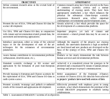
OBJECTIVES ASSESSMENT Define common research areas in the overall field of
the environment.
Common research areas have been selected on the basis of common scientific criteria and a mutual understanding of existing needs. They have been appropriately established, a fact which enhances the potential for substantial Chino-Europe scientific cooperation. Research areas reflect important contemporary environmental and development issues. Promote the use of ESA, TPM and Chinese EO data for
science development.
Greatly achieved, a fact which provides the space for the development of a common data platform.
Use ESA, TPM and Chinese EO data, in conjunction with climate and environmental-related ground data, for assessment and monitoring applications.
Important progress, yet lack of climate and environment – related ground data may be an issue in some cases.
Introduce innovation, either in terms of the selected topics or for the development of state of the art techniques for the estimation of environmental parameters.
Although the majority of the projects use existing methods, the innovation dimension is high as methods are fined tuned and new products are developed on the basis of the synergy of ESA, TPM and Chinese EO data.
Assess human contribution to environmental problems (urbanization, desertification, etc.),
Products so far clearly demonstrate the link between human activities and environmental problems.
Stimulate scientific exchange in EO science and application by the formation of joint Sino-European teams.
Achieved; it is considered critical for synergies to be promoted and is maintained by means of annual plenary meetings and project to project communications. Provide training to European and Chinese scientists for
the exploitation of ESA, TPM and Chinese EO data in earth system science.
Better acquaintance of the European (Chinese) scientists to Chinese (ESA) EO data has been achieved as projects’ products have used both sources of data.
Promote scientific twinnings and publish co-authored results of the research and applications development.
Effectively promoted with emphasis given to young scientists, a fact which demonstrates the potential of the overall DRAGON programme to establish lasting collaborations.
Table 1. Assessment of DRAGON 3 in terms of its objectives.
Table 2 summarizes findings and recommendations as they yield from an assessment of the projects’ progress.
DATA
Improve the access to near real time EO data in European side (it is expected that this will be achieved through Sentinel);
Common EO database to be developed between European and Chinese sides. Database should be fully accessible and also include radar/optical data, and ancillary data. In terms of limitations:
TIR data need to be improved in terms of their spatial and temporal resolution. MW data needs better spectral resolution (more bands).
Optical data needs 100 m resolution global daily cover.
OPERATIONAL USE
Develop an open access data policy (and a common EO data portal) between ESA and China so as to support the operational use of data.
Link the Sentinel series to GF series to generate an “operational constellation” with
daily global coverage. VALIDATION
Better access to ancillary data. An improved link of DRAGON to international initiatives providing ancillary data, should be promoted.
NEW THEMATIC AREAS
Cities (urbanization, climate change, urban health) Ecosystem observation
Agriculture (as an individual thematic area).
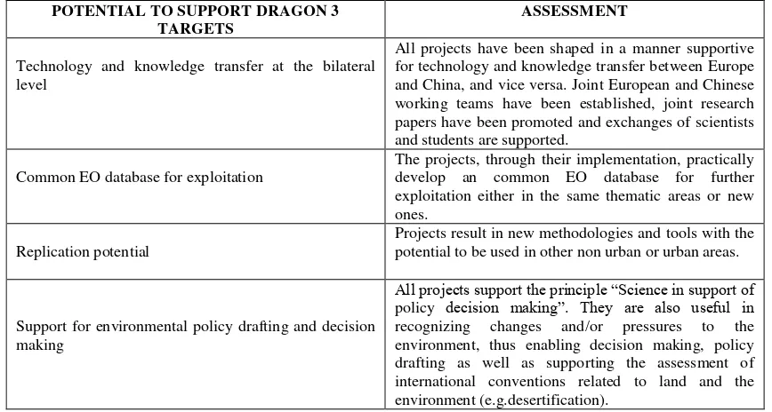
Finally, Table 3 presents an assessment of the capacity of the projects to support a multitude of targets. POTENTIAL TO SUPPORT DRAGON 3
TARGETS
ASSESSMENT
Technology and knowledge transfer at the bilateral level
All projects have been shaped in a manner supportive for technology and knowledge transfer between Europe and China, and vice versa. Joint European and Chinese working teams have been established, joint research papers have been promoted and exchanges of scientists and students are supported.
Common EO database for exploitation
The projects, through their implementation, practically develop an common EO database for further exploitation either in the same thematic areas or new ones.
Replication potential
Projects result in new methodologies and tools with the potential to be used in other non urban or urban areas.
Support for environmental policy drafting and decision making
All projects support the principle “Science in support of policy decision making”. They are also useful in recognizing changes and/or pressures to the environment, thus enabling decision making, policy drafting as well as supporting the assessment of international conventions related to land and the environment (e.g.desertification).
Table 3. An assessment of the potential of the projects to support DRAGON 3 targets. ACKNOWLEDGEMENTS
This paper is supported by the ESA Dragon 3 Programme.
REFERENCES
Ban, Y., Gamba, P., Jacob, A., Salentining, A., 2014. Multitemporal, multi-rsolution SAR data for urbanization mapping and monitoring:midterm results, Session on ‘Land and Environment’ in Proceedings of the Dragon 3 mid-term results Symposium, 26 to 29 May 2014, Chengdu, P.R. China, ESA SP-724, ISBN: 978-92-9221-288-9. Cartalis, C., Polydoros, A., Mavrakou, Th., and Assimakopoulos, D.N., 2014. Earth observation in support of the development of adaptation plans for climate change in cities, Session on ‘Land and Environment’ in Proceedings of the Dragon 3 mid-term results Symposium, 26 to 29 May 2014, Chengdu, P.R. China, ESA SP-724, ISBN: 978-92-9221-288-9.
Desnos, Y.L., Li, Z., Zmuda, A., Gao, Z, 2014. Progress and achievements at the mid term stage of the DRAGON 3 programme, Session on ‘Land and Environment’ in Proceedings of the Dragon 3 mid-term results Symposium, 26 to 29 May 2014, Chengdu, P.R. China, ESA SP-724, ISBN: 978-92-9221-288-9.
Gao, Z., Barrio, G., Li, X., Wang, B., Puigdefabreagas, J., Sanjuan, M., Bai, L., Wu, J., Sun, B., Li, C., 2014. Mid Term Progress Report: Desertiification assessment and monitoring based on remote sensing, Session on ‘Land and Environment’ in Proceedings of the Dragon 3 mid-term results
Symposium, 26 to 29 May 2014, Chengdu, P.R. China, ESA SP-724, ISBN: 978-92-9221-288-9. Liu, Z-Y, Li, C-R, Tang, L-L., Zhou, X-N., Ma, L.,2014. Research on dynamic monitoring (1990-2010) of schistosomiasis vector snail at Xinmin Beach, Jiangsu Province China, Session on ‘Land and Environment’ in Proceedings of the Dragon 3 mid-term results Symposium, 26 to 29 May 2014, Chengdu, P.R. China, ESA SP-724, ISBN: 978-92-9221-288-9.
Salentinig, A., Gamba, P., 2014. Multi-scale SAR image fusion at the feature level for enhanced urban area extraction, Session on ‘Land and Environment’ in Proceedings of the Dragon 3 mid-term results Symposium, 26 to 29 May 2014, Chengdu, P.R. China, ESA SP-724, ISBN: 978-92-9221-288-9. Xu, W. And Fan, J., 2014. Estimation of winter wheat yield with the assimilation of FY-3 MERSI data into the WOFOST crop growth model, Session on ‘Land and Environment’ in Proceedings of the Dragon 3 mid-term results Symposium, 26 to 29 May 2014, Chengdu, P.R. China, ESA SP-724, ISBN: 978-92-9221-288-9.