Relations between mud volcanoes, thrust
deformation, slope sedimentation, and gas
hydrate, offshore north Panama
Donald L. Reed, E. A. Silver and J. E. Tagudin
Earth Sciences Board and Institute of Marine Sciences, University
of California, Santa Cruz, California 95064, USA
T. H. Shipley
Institute for Geophysics, University of Texas, Austin, Tx 78751,
USA
P. Vrolijk
Department of Geological Sciences, University of Michigan, Ann
Arbor, Michigan 48109, USA
Received 1April 1989;accepted 1September 1989
ABSTRACT
SeaMARC II swath-mapping and migrated seismic reflection data
show a high concentration of mud volcanoes in the primary sediment
depocentre along the lower slope of a thrust belt, offshore north
Panama.
pierced the crests of dominantly seaward-verging, thrust-bounded
anticlines, landward of the frontal fold.
The depocentre marks the confluence of the two major sediment
transport systems along the northern Panama margin.
Few mud volcanoes are located outside of the depocentre, except in a
mid-slope region slightly east of the depocentre and near a zone of
probable strike-slip deformation.
Sonar reflectivity (backscattering), sediment cores, and seismic
stratigraphic relations indicate that the depocentre contains thick
sequences of basinal turbidites which are ponded between the
anticlinal ridges.
The ridges are composed of the deformed turbidites of the Colombian
basin and exhibit a strong bottom-simulating reflector (BSR),
apparently associated with a gas hydrate layer.
Based on the concentration of mud volcanoes along the crests of the
anticlinal ridges in the depocentre and the structural position of the
BSR, we suggest that folding along the deformation front, sediment
ponding leading to differential loading, methane migration and
accumulation in the anticlines, and gas hydrate formation are
important factors in the development of mud volcanoes in this region.
Keywords: mud volcanoes; submarine thrust belt; offshore
ABSTRAK
(INDONESIA)
Data dari pemetaan menyamping (swath-mapping ) SeaMARC II dan
penampang seismiK yang telah dimigrasi (migrated seismic reflection)
memperlihatkan mud volcano dengan konsentrasi yang tinggi pada
deposenter utama sedimen (primary sediment depocenter) sepanjang
lereng bawah (lower slope) jalur sesarnaik (thrust belt), lepas pantai
Panama utama.
Mud volcano dengan lebar 0,4-2 km, tinggi kurang dari 100m, dan
mempunyai penonjolan (pierced the crests) di puncak yang
didominasi penyebaran ke arahl aut (seaward-verging), antiklin
dibatasi oleh sesarnaik (thrust-bounded anticlines), ke arah daratan
dari lipatan terdepan (landward of the frontal fold).
Deposenter ditandai oleh pengaruh dari dua sistem pengangkutan
sedimen (two major sediment transport systems) sepanjang tepian
Panama utara.
Beberapa mud volcano berlokasi dil uar dari deposenter, kecuali di
derah lereng tengah (mid-slope region) agak ke timur dari deposenter
dan dekat dari suatu sone deformasi yang kemungkinan adalah sesar
geser (strike-slip deformation).
Sonar reflectivity (backscattering), sediment cores, and seismic
stratigraphic relations indicate that the depocentre contains thick
sequences of basinal turbidites which are ponded between the
Pantulan sonar (sonar reflectivity), sedimen inti (cores sediment), dan
hubungan stratigrafi seismic (seismic stratigraphic relations)
mencirikan bahwa deposenter terdiri dari sekuen tebal turbidit
cekungan (basinal turbidites) yang teronggok (ponded) antara
punggungan antiklin (anticlinal ridges).
The ridges are composed of the deformed turbidites of the Colombian
basin and exhibit a strong bottom-simulating reflector (BSR),
apparently associated with a gas hydrate layer.
Punggungan terdiri dari turbidit yang terdeformasi (deformed
turidites) dari cekungan Columbia dan memperlihatan pemantul
dasar yang kuat (a strong bottom-simalting refector BSR), yang
tampaknya berasosiasi dengan lapisan gras hidrat (a gas hydrate
layer).
Berdasarkan konsentrasi dari mud volcano sepanjang puncak dari
punggungan antiklin (anticlinal ridges) di deposenter dan posisi
struktur dari BSR, kami percaya bahwa lipatan sepanjang bagian
depan deformasi (deformation front), sedimen teronggokan (sediment
ponding) dengan pembebanan yang berbeda (differential loading),
migrasi metan (methane migration) dan akumulasi pada antiklin, dan
pembentukan gas hidrat merupakan faktor penting terhadap
perkembangan mud volcano di kawasan ini.
Katakunci: gunung lumpur (mud volcano), sabuk sesarnaik di
dasar laut (submarine thrust belt), lepas pantai Panama (offshore
INTRODUCTION
Mud volcanoes and shale diapirs have been described from a wide
variety of tectonic environments, including passive continental
margins (Hedberg, 1980) and continental interiors (Fertl, 1976), as
well as transform (Higgins and Saunders, 1967) and convergent plate
boundaries (Stride et al.. 1982).
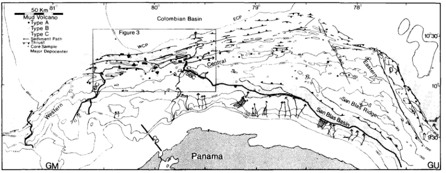
Figure 2 Major tectonic features and distribution of mud volcanoes in the north
Panama thrust belt (NPTB) superimposed on SeaMARC II bathymetry at 500 m contour interval. Mud volcanoes are differentiated into Types A, B, and C. Deformation front is located along northern extent of major thrust and oblique-trending faults. Major sediment transport systems are noted with arrows
In the latter setting, the structural position of mud volcanoes has
been fundamental to models relating sediment deformation to high
pore fluid pressures within and along the base of accretionary prisms
(Westbrook and Smith, 1983).
Furthermore. mud volcanoes and diapirs have been suggested as a
means of generating the deformed melanges which characterize
ancient subduction complexes (Williams et al., 1984; Barber et al.,
Figure 3 continued
Several studies have examined individual volcanoes or mud ridges
(Westbrook and Smith. 1983; Breen et al., 1986; Langseth et al.,
1988).
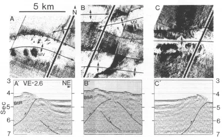
Figure 4 Side-scan image and migrated reflection profiles of mud
volcanoes. A-A', Culmination of an anticline that is capped by three mud
volcanoes. Note tight folding of anticline and bottom-simulating reflector
(BSR) in hinge zone. B-B', Mud volcano along anticlinal ridge which deflects
Brown and Westbrook (19881) combined GLORIA side-scan
sonographs with multichannel seismic data to map the distribution of
mud volcanoes along the Barbados Ridge Complex of the Lesser
Antilles forearc.
We use SeaMARC II and 57 migrated reflection profiles to examine the
distribution of mud volcanoes in another region of lithospheric
convergence, a submarine thrust belt along northern Panama (Figure
1).
Although we use the term 'mud volcano', direct observations and
bottom samples are not available at this time.
Our analysis is based on sonar images of features which have
breached the sea floor and are therefore inferred to represent sites of
extruded sediment, fluids, or gas. These features may be analogous to
the mud volcanoes and diapirs that have been described in the
nearby offshore and onshore regions of Colombia (Shepard, 1973;
Hedberg, 1980).
The distribution of mud volcanoes is compared to the location of the
principal structural features and sedimentary deposits in the thrust
belt.
We then examine the possible consequences of fold-thrust formation
on the development of the mud volcanoes. These processes can
generate mud volcanoes by themselves (Hedberg, 1974; 1980) or
produce a Data acquisition and processing Approximately 47 000 km
z of the northern Panama margin were surveyed with the SeaMARC II
and digital seismic reflection systems aboard the R/V Moana Wave of
the Hawaii Institute of Geophysics (HIG).
High resolution SeaMARC II side-scan sonar and bathymetric data
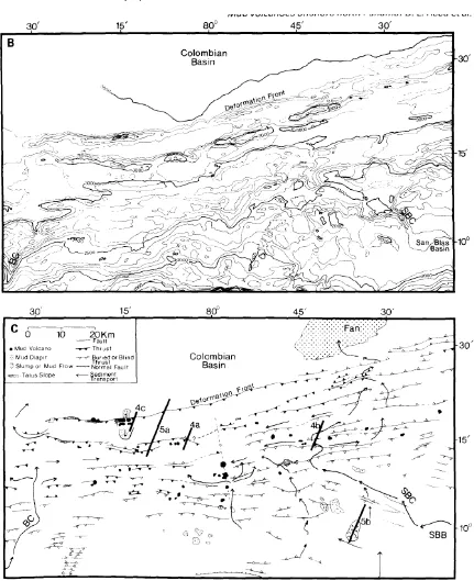
were merged into a continuous map that is traversed every 7-10 km
by a seismic reflection profile (Figure 1B).
Colour-coded bathymetry was hand-contoured at 100 m, compared
with computer-contoured plots, and overlain on the side-scan sonar
map.
Side-scan sonographs were used to interpolate water depths between
Single-channel digital reflection data were processed through
deconvolution, time-varying bandpass filter, automatic gain control
(AGC), and finite-difference (45 °) migration.
Reflectivity of the side-scan sonar data and shallow seismic
stratigraphic relations were integrated with descriptions of seven
piston cores (Figure 2; Table 1), obtained from the National
Geophysical Data Center (NGDC). The cores range in length from 36
to 850 cm.
Regional setting The northern margin of Panama is composed of a
wide belt of deformed strata (Bowin, 1976; Case and Holcombe,
1980), hereafter referred to as the north Panama thrust belt (NPTB)
(Figure 1).
The onset of thrusting is poorly known, but probably coincided with
the Late Neogene collision of the Panamanian arc with South America
(Wadge and Burke, 1983).
Silver el al. (1990) combined structural analyses of the NPTB with the
relative plate motions of the Caribbean, Cocos and Nazca plates to
estimate NNW-oriented Panama- Caribbean convergence at 1-15
mm/yr (Figure 1).
The western Colombian basin is underlain by relatively thick oceanic
crust that is believed to be of Cretaceous age (Christofferson, 1976;
Bowland and Rosencrantz, 1988).
Sediment thicknesses in the basin, near the NPTB, vary between 1.5
and >3.0 s (two-way time) (Tagudin, 1988). Lu and McMillen (1982)
subdivided the seismic stratigraphy of the western Colombian basin
the NPTB and basin-type deposits which are located seaward of the
central region.
Bowland (1984) interpreted these units as being composed of
mid-Tertiary to recent volcaniclastic and carbonate turbidites which
overlie pelagic and hemipelagic deposits of probable late Cretaceous
to early Tertiary age.
GEOLOGICAL
FRAMEWORK
OF
THE
THRUST
BELT
SeaMARC lI and digital reflection data provide an excellent image of
nearly the entire thrust belt (-34 700 km2). The NPTB consists of
three structural provinces (Figure 2): (1) an eastern province
characterized by NW-trending thrust-bounded folds and two
NNW-trending faults which cut obliquely across the thrust belt; (2) a
central province composed of ENE-trending thrust-bounded folds;
and (3) a western province where the thrust-bounded folds trend NE
and the thrust belt is narrow, apparently associated with decreased
convergence between western Panama and the Colombian Basin
(Silver et al., 1990).
The central province, covering -17 000 km ~, consists of widely
spaced (7-8 km) anticlinal ridges separated by slope basins. The
central province can be subdivided into western and eastern regions,
based on the direction of fold vergence (Tagudin, 1988), abundance of
mud volcanoes, and presence of lower slope turbidite deposits.
The western region of the central province (WCP in Figure 2) is
dominantly composed of seaward-verging, thrust-bounded folds,
The slope basins of the WCP contain thick turbidite deposits (700-900
m) which are ponded between the ridges. In contrast,
landward-verging folds with very few mud volcanoes characterize the eastern
region of the central province (ECP in Figure 2).
Turbidite deposition is sparse along the lower slope of the ECP as
deposits drape over topographic features, typical of hemipelagic and
pelagic sediments. Slope basins in both the western and eastern
provinces of the thrust belt are devoid of turbidites.
The western province contains two submarine canyons which allow
detritus to bypass the lower slope, resulting in turbidite fans in the
Colombian basin, seaward of the deformation front (Figure 2).
The upper slope in the eastern province is composed of a >250
km-long ridge, hereafter called the San Blas ridge (Figure 2).
The ridge acts as a barrier to sediment transport to the lower slope of
the province, thereby restricting clastic deposition to the San Blas
basin along the southern margin of the ridge.
The basin contains 1-3 kin-thick turbidite sequences which are
deformed and incorporated into the rear of the NPTB along several
prominent backthrusts.
CHARACTERISTICS
AND
DISTRIBUTION
OF
MUD
VOLCANOES
Side-scan images in the NPTB that may be related to mud volcanoes
were assigned to three types (A, B, C) according to the degree to which
these features can be distinguished from slumps, rock outcrops, talus
slopes, and debris flows.
Type A exhibits the most well-defined features commonly associated
view), high sonar reflectivity, positive bathymetric relief, and widths
up to 2 km (Figures 3A and 4A).
The sea floor surrounding Type A mud volcanoes is relatively flat,
typically formed by the broad crests of anticlinal ridges.
In contrast, Type B features are irregularly shaped, generally <1
kin-wide, and commonly located along steep bathymetric slopes.
The position along steep slopes, combined with the irregular shape,
imply that some of the Type B features are probably related to
slumping or rock outcrops rather than mud extrusion.
Finally, Type C features differ markedly from Types A and B by
forming either highly irregularly-shaped regions along the sides of
canyons or the bases of prominent scarps. Type C features are most
likely associated with slump deposits or scars, slope gullies, and talus
along fault scarps.
We chose to limit our analysis to Type A features (e.g. Figure 4A),
because their well defined sonar image is the most characteristic of
mud volcanism.
The inclusion of Types B and C does not alter the principal findings of
our study. A total of 44 Type A mud volcanoes were identified as
highly reflective, circular to slightly elliptical features (Figures 2 and
3A).
The mud volcanoes vary in width (0.4-2.0 km) and are <100 m high,
as suggested by the lack of closure of consecutive 50 m isobaths on
SeaMARC bathymetry.
The mud volcanoes occur as solitary features or clustered in groups,
composed of as many as six volcanoes. The highest concentration of
of the central province (WCP in Figure 2).
Thirty-two of the mud volcanoes, or 73% of the total, are located in
the ~2400 km 2 region which composes 7% of the thrust belt area.
Twenty-six of the mud volcanoes are located along structural
culminations in the anticlinal ridges, especially along the more tightly
folded anticlines (Figure 4).
Three of the mud volcanoes are aligned along a NNW trend which may
delineate an oblique-trending fault (Figure 3C).
Mud volcanoes were not observed seaward of the deformation front, in
contrast to observations in other accretionary prisms (Westbrook and
Smith, 1983: Breen et al., 1988; Langseth et al., 1988).
In fact, very few mud volcanoes are located at the deformation front
and these are restricted to a small region that has been modified by
gravitational slope failure (Figures 3 and 4C).
Either mud volcanism or slope failure could be responsible for these
features and the two processes may be related.
For example, deformation and fluid migration associated with mud
eruptions may result in slope failure. This region forms the steepest
slope along the frontal fold and thus gravitational failure might be
expected.
Conversely, a rapid decrease in overburden following slumping may
stimulate the ascent of overpressured sediments in the underlying
strata, analogous to the catastrophic rock slide which triggered the
lateral blast of the 18 May 1980 volcanic eruption at Mount St Helens
(Voight et al., 1981).
Approximately 8 km west of this region, two mud volcanoes are
occurrence in the NPTB (Figure 3A).
Type A mud volcanoes, outside of the WCP, are scattered and
represent a small proportion (27%) of the total within the NPTB. Many
of these features are located in the mid-slope area of the central
province, slightly east of the Type A concentration in the WCP and
near oblique-trending faults in the eastern province (Figure 2).
The underlying structural and stratigraphic framework in these
regions is complicated and poorly imaged by our data.
However, the mud volcanoes exhibit several characteristics that can
be distinguished from those of the WCP.
The mud volcanoes are highly variable in width in the mid-slope
region, and generally smaller (<1.0 km-wide).
The small size precludes assignment of a particular shape or height to
these features and may reflect partial burial by sediments in some
regions.
Direct observations of the sea floor are necessary to test this
possibility. Mud volcanoes offshore north Panama: D. L. Reed et al.
Several mud volcanoes are located near the oblique-trending faults
which cross the thrust belt in the eastern province.
The mud volcanoes are elongated, lacking the characteristic circular
shape (map view) of the mud volcanoes elsewhere in the thrust belt.
Silver et al. (1990) interpreted these faults as right-lateral shears
associated with oblique convergence in the eastern province.
Mud volcanoes have been previously reported along strike-slip faults
in other regions of compressive deformation (e.g. Ridd, 1970; Brown
LOWER
SLOPE
DEPOCENTRE
OF
THE
CENTRAL
PROVINCE
The large majority of mud volcanoes are located in the major
sediment depocentre along the lower slope of the NPTB.
The depocentre is formed by the merging of the two major sediment
transport systems in the WCP (Figure 2). One of the systems is
composed of a linear canyon (BC in Figure 3B) along the western edge
of the depocentre which transports detritus directly to the Colombian
basin, bypassing much of the lower slope. Core sample 03065005
near the associated fan deposit contains sand and silt-sized detritus
(Table 1, Figure 2).
Because of the curvature of the deformation front in this region, the
southeastern margin of the sedimentary deposit extends eastward
into the lower slope depocentre.
The depocentre is, however, fed primarily by a canyon system which
extends downslope from the western edge of the San Bias basin. The
configuration of this transport system results in the stepwise
partitioning of detritus into three interconnected depocentres: (1) the
San Bias basin along the upper slope of the eastern province: (2) the
lower slope depocentre: and (3) the Colombian basin seaward of the
central province (Figure 2).
The depocentres are linked by channels and canyons which extend
laterally along the thrust belt from the eastern Panama shelf in the
Gulf of Uraba to the floor of the Colombian basin, a total distance of
-350 kin.
The configuration of the transport system is critical to the
development of sedimentary deposits in the region of the mud
region.
The system acts as a funnel concentrating detritus derived from the
eastern and central regions of northern Panama, a mountainous
terrane covering -15 000 km 2, into the WCP of the thrust belt.
The upper portion of the system consists of a 5 kin-wide canyon
which extends from the eastern Panama shelf to the eastern San Blas
basin.
The canyon connects with a >250 km long channel which runs along
the axis of the San Bias basin. The axial channel receives additional
detritus from numerous canyons which extend down from the upper
slope.
The channel bends around the San Blas ridge at the western edge of
the San Bias basin and extends downslope along the San Bias
submarine canyon (Figures 2 and 3). The canyon bifurcates into
several channels which meander through the lower slope of the WCP,
feeding the slope basins which compose the depocentre.
The main channel breaches the frontal fold and terminates in a
turbidite fan in the Colombian basin, seaward of the deformation
front (Figures 2 and 3C).
The slope basins contain 0.4-0.8 s thick turbidite sequences which
lap onto the southern limbs of the thrust-bounded anticlines (Figures
4C and 5A).
The anticlines are composed of folded basinal turbidites, originally
deposited in the Colombian basin (Lu and McMillen, 1982). It is
noteworthy that the depocentre represents the only significant
collection of clastic (?) turbidites along the lower slope of the NPTB
mud volcanoes.
The relationship of sonar reflectivity (backscattering) to sediment
facies is complicated as both slope angle and sea floor roughness
affect reflectivity, as well as sub-bottom (<1 m) sediment layers (Lee et
al., 1988).
Long range sonar studies, however, have shown that low sonar
reflectivity can correspond to fine-grained sediments in abyssal
settings, whereas regions of high reflectivity characterize sand-and
silt-bearing deposits (e.g. Kidd et al., 1985).
The low reflectivity regions of the NPTB are located along the
anticlinal ridges whereas the San Bias basin and the slope basins of
the lower slope depocentre are marked by high reflectivitv regions.
Sedimentological data are sparse and widely spaced in the NPTB
(Figure 2), although seven piston cores (Table 1) suggest that the
moderate to high reflectivity regions correspond to sand-and
silt-bearing deposits.
Low reflectivity regions mark clay-and ooze-bearing sediments.
Furthermore, the main sediment transport system exhibits a
progressive decrease in reflectivity from the San Blas basin, to the
lower slope depocentre, and finally to the fan complex seaward of the
deformation front.
DISCUSSION
Mud volcanoes form in a variety of tectonic environments. For
example, mud volcanoes along the passive continental margin in the
Gulf of Mexico are remarkably similar to those in the NPTB (see
Consequently, a variety of processes operating alone or in concert,
may result in the ascent and extrusion of the low density muds. The
association of mud volcanoes with regions of overpressure is,
however, a common observation in many regions (Hedberg, 1974,
1980; Fertl, 1976; Westbrook and Smith, 1983).
One of the best studied examples of mud volcanoes associated with
compressional tectonics is the accretionary prism of the Barbados
Ridge Complex (Stride et al., 1982).
The mud volcanoes in this region are located both within and seaward
of the accretionary prism. Most of the mud volcanoes are located in
the southern portion of the prism which is marked by the accretion of
the Orinoco fan complex.
Westbrook and Smith (1983) attributed the seaward volcanoes to
loading by the prism and hydrofracturing along a proto-decollement.
Langseth et al. (1988) suggested that fluid migration leading to the
development of the seaward mud volcanoes is also influenced by a
ridge in the underlying oceanic basement.
Brown and Westbrook (1988) observed that mud volcanoes within the
prism commonly overlie reverse faults and mark regions of subcretion
(underplating).
The distribution of mud volcanoes in the NPTB differs from the
Barbados Ridge Complex in several important ways. (1) The accreted
strata in the volcano-rich WCP consist largely of basinal turbidites
(Lu and McMillen, 1982). In contrast, the regions of accreted fan
deposits in the western and eastern provinces exhibit very few mud
volcanoes (Figure 2). (2) Mud volcanoes were not observed seaward of
evidence of structures in the oceanic basement seaward of the WCP
which would correspond to the distribution of mud volcanoes
(Bowland and Rosencrantz, 1988; Tagudin, 1988). (4) The majority of
mud volcanoes are located along the crests of thrust-bounded
anticlines, not along reverse faults exposed on the sea floor. (5) The
mud volcanoes do not appear to coincide with regions of subcretion,
at least along the lower slope. The absence of subcretion is especially
evident where mud volcanoes occupy the crests of the frontal fold and
the next fold landward (Figures 4C and 5A). The upper slope of the
NPTB exhibits few mud volcanoes, although subcretion may be active
in this region.
Mud diapirs, however, were observed along the upper slope (Figure
5B) (Vitali et al. , 1985). Breen et al. (1988) suggested that mud layers
in the vicinity of the decollement are the stratigraphic source of the
mud volcanoes in the NPTB. Unfortunately, the source horizon can
not be accurately determined from the existing data, partly because
no reflection profile passes directly over a mud volcano.
A combination of processes, such as described below, may be the
driving force of mud volcanoes in the NPTB or combine with diapirism
and folding as envisioned by Breen et al. (1988).
Sediment
loading,
methane
generation
and
gas
hydrate?
High sedimentation rates seaward of the deformation front are a
contributing factor to the development of high pore fluid pressure in
the Barbados Ridge Complex (Shi and Wang, 1985).
High sedimentation rates alone, however, may not account for NPTB
mud volcanoes. The thickest sedimentary deposits and, presumably,
the major fan complexes seaward of the deformation front in the
western and eastern provinces (Figure 2). Very few mud volcanoes
were observed in these regions or within the thrust belt, landward of
these regions.
The fact that the majority of the NPTB mud volcanoes are located in
the lower slope depocentre suggests that these deposits have
influenced mud volcano development.
The relative timing of sedimentation in the depocentre and the
formation of the mud volcanoes can be inferred from seismic
stratigraphic relations.
Folding of the Colombian basin strata along the deformation front has
produced a series of anticlinal ridges that divide the depocentre into
several slope basins (Figures 2 and 5A).
In some regions, the ridges may contain diapiric mud intrusions
which may have developed in response to folding above the
decollement (Breen et al., 1988).
Growth folding in the slope basin strata indicates that turbidite
deposition was contemporaneous with folding (Fig,~res 4 and 5A). The
location of nearly all of the mud volcanoes along anticlinal ridges
landward of the deformation front, rather than along the deformation
front itself, suggests that volcano formation followed fold nucleation.
Therefore, we infer that thrusting and folding along the deformation
front developed concurrently with the deposition of slope basin
turbidites, and that mud volcanism followed thereafter.
The onset of slope deposition prior to volcanism suggests a possible
cause and effect sedimentary deposits of the lower slope depocentre
volcanism, through differential loading and the generation and
accumulation of methane gas.
Loading by the slope basin strata produces a fluid pressure gradient
between the slope basins and the hinge zones of the anticlinal ridges.
Magara (1986) showed that fluid flow is directed towards the hinge
zones m response to such a gradient and will be stratigraphically
controlled at moderate depths by the formation of pressure seals
within shale layers, such as contained in turbidite sequences.
The difference in hydraulic head (sum of the elevation head and
pressure head) a stratigraphic horizon beneath the slope basin
deposits and the same horizon in the fold hinge is one measure of the
pressure gradient (Freeze and Cherry, 1979).
For example, a simple depth conversion of the anticlinal ridge and
basin couple in Figure 4 shows that a layer located in the fold hinge is
buried by an additional 700 m of sediment and 300 m of sea water in
the region of the slope basin.
There is no difference in hydraulic head between the regions under
hydrostatic conditions. However, if lithostatic conditions prewdl, then
the pressure head (and hydraulic head) for a layer under the slope
basin.
Therefore, a strong pressure gradient resulting from the difference in
hydraulic head will develop under lithostatic conditions with the
associated fluid flow in the direction of the hinge zones (Figure (7).
Tectonic loading by the stacking of seaward-verging thrust sheets
may also contribute to the fluid pressure gradient in the depocentre.
Methane generation and migration provides another mechanism for
Indeed, mud volcanoes throughout the world arc associated with
abundant release of methane gas (Hedberg, 1980).
Methane accumulations and x.enting have been documented in
several compressional settings, including the Barbados Ridge complex
(Moore et al., 1988), Nankai trough (LePichon et al., 1987) and the
Oregon-Washington accretionary prism (Ritger et al., 1987).
Brown and Westbrook (1988) suggested a secondary role for methane
in the formation of mud volcanoes at the Barbados Ridge complex.
Evidence of methane in the NPTB includes the widespread presence of
a bottom-stimulating reflector (BSR) in seismic profiles (Figures 4 and
5A) (Lu and McMillen, 1982).
BSRs are produced by an impedance contrast between gas (methane)
hydrate and underlying sediments which, in some cases, contain gas
as a free phase (Bryan, 1974: Shipley el al., 1979).
Gas hydrate is an ice-like compound that traps methane in the
crystal lattice (Kvenholden and Barnard, 1982) and decreases the
permeability of the host sediment (deBoer el al., 1985).
The BSR has not been directly sampled in the NPTB. However,
biogenic methane is abundant in Pliocene turbidites of the Colombian
basin and the more deeply buried rocks in the basin are thermally
mature, leading to generation of additional methane (Finley and
Krason, 1987).
Sub-bottom depth (two-way time) to the BSR in the NPTB increases
with increasing water depth and the reflection polarity is reversed (T.
H. Shipley, unpublished data), typical of gas hydrates. The BSR is
commonly observed within the anticlinal ridges (Figures 4A and 5B),
The very low permeability of the hydrate provides an effective seal for
trapping methane gas in the hinge zone (deBoer et al., 1985). In
addition, the hemipelagic sediments which drape the anticlinal ridges
may be less permeable than the underlying turbidites, thus
contributing to the formation of a lithologic seal.
The range of P-T conditions (13-18°C; -350-500 bars), estimated for
the base of the hydrate in the anticlines, is compatible with methane
existing as free gas, dissolved in pore fluid or both.
Although the BSR is widespread along northern Panama, the
combination of deformation, sediment loading, and the amount of
methane may vary from one region to another, the latter in
accordance with the volume of clastic sediments, content of organic
carbon in these sediments, degree of methane generation, and the
development of suitable migration paths and reservoirs for methane
accumulation.
Unfortunately, it is not possible to determine the sedimentological
characteristics of the depocentre without additional core samples.
However, the depocentre contains the largest volume of elastic
turbiditc deposits along the lower slope of the thrust belt and that, in
itself, may provide an additional source for methane as compared to
other regions of the NPTB.
We suggest that folding along the deformation front stimulates the
up-dip migration of methane and methane-saturated pore fluids into
the hinge zones of the anticlinal ridges (Figure 6).
Density-driven migration of methane may be enhanced by fluid flow
related to loading by the slope basin turbidite sequences. Vertical
hemipelagic sediments, resulting in increased methane
concentrations which are a necessary condition for hydrate
development under favourable P- T conditions (Kvenholden and
Barnard, 1982: deBoer et al., 1985).
Triggering
mechanism
for
mud
eruptions
Hydrate formation increases the strength and cohesion, and
decreases the permeability within the host sediment (deBoer et al.,
1985). Buoyancy forces will promote methane migration towards the
hinge zone, resulting in the displacement of pore fluids beneath the
hydrate.
The sub-hydrate accumulation of methane will increase pore fluid
pressure, already elevated by regional tectonic and loading
phenomena.
Methane and methane-saturated pore fluids also decrease the bulk
density of the sediments beneath the seal, thus providing a buoyancy
force for diapirism and mud volcanism if the seal is ruptured
(Hedberg, 1974).
The sediments which are extruded by a mud volcano must either pass
through the zone of hydrate or be derived from within it (Figure 6).
Hence the rupture of the hydrate seal provides a critical event in the
evolution of the sediment which is ultimately extruded at the sea
floor.
Thinning and weakening of the seal by deformation or changes in P-T
conditions may act to trigger eruptions. Unfortunately. our migrated
reflection profiles do not image the detailed structural relations in the
Possible causes of seal rupture include faulting along the tops of the
anticlines, fracturing ahead of ascending diapirs, and
hydrofracturing.
Hydrofractures will develop if pore fluid pressures are large enough to
exceed confining pressures in the hinge zone (Magara, 1986). A
change in P-T conditions, such as a reduction in pressure or increase
in temperature, can also result in hydrate weakening and
decomposition.
Processes that may perturb P-T conditions include removal of
overburden by slumping and thus reducing confining pressure and
the introduction of warm pore fluids migrating upward along fold
limbs, faults, or hydrofractures.
Hydrate decomposition releases large quantities of methane, resulting
in a 170-fold increase in the volume of pore fluids (including free gas)
at 1 atmosphere (Kvenholden and Barnard, 1982).
The volumetric increase will be much less at the pressures associated
with depth of the hydrate in the NPTB, because of the compressibility
of methane. Even so, the released methane will displace pore fluids
and increase pore fluid pressures, if permeability of the host sediment
is low.
Once the seal is ruptured, pore fluid pressures will decrease leading
to the rapid expansion of methane which, in turn, may account for
the violent eruptions which characterize many mud volcanoes
(Hedberg, 1980).
Distribution
of
mud
volcanoes
and
vergence
two important ways: (1) the slope basin deposits are substantially
thicker in the WCP and (2) seaward verging thrusts are common in
the WCP whereas landward verging thrusts characterize structures in
the ECP (Tagudin, 1988).
Landward vergence is commonly believed to be evidence of low shear
stress, and high pore fluid pressure, along the ddcollement (Seely,
1977). Likewise, mud volcanoes are commonly associated with
regions of high pore fluid pressure (Westbrook and Smith, 1983).
Therefore, mud volcanoes might be expected to predominate in the
regions of landward-vergence, such as the ECP. The opposite
relationship is observed in the NPTB, however.
We present several hypotheses for this enigma. First, vergence and
mud volcanism may reflect processes operating at different depths,
such that vergence is controlled by conditions at the base of the
thrust belt whereas the mud volcanoes may be driven by processes at
shallow depth within the lower slope depocentre. Tagudin (1988)
correlated the distribution of landward verging folds with the lateral
extent of a mid-Tertiary (?) seismic stratigraphic sequence in the
vicinity of the ddcollement.
Second, the frontal fold in the WCP does not display a sense of
vergence during the early stages of deformation (Breen el al., 1988),
consistent with the concept of low shear stress along the ddcollement
(Seely, 1977). The gentle sea floor slope (1-2 °) in the central province
also suggests low shear stress along the ddcollement, based on the
concept of wedge taper (Breen el al., 1988: Davis et al., 1983). Fluid
venting by mud volcanoes, shortly after fold nucleation, may increase
development of seaward-verging thrusts.
Third, slope basin deposits of the WCP are ponded landward of the
anticlinal ridges, resulting in increased compaction or pore fluid
pressure along the south-dipping limb as compared to the
north-dipping limb. Loading by the slope basin deposits results in pore fluid
flow along the south-dipping limb of the frontal fold. Fluid flow and
differential compaction along this limb may form a south-dipping
anisotropy which could influence the geometry of the incipient thrust.
CONCLUSIONS
Mud volcanoes are concentrated along thrust-bounded anticlinal
ridges in the only lower slope depocentre in the NPTB. The depocentre
consists of several slope basins containing thick turbidite deposits.
Differential loading caused by the slope basin deposits, combined
with the generation and migration of methane, may contribute to the
development of high pore-fluid pressure in the adjacent anticlinal
ridges.
Methane accumulation in the hinge zones of the ridges has resulted
in the formation of gas hydrate. The hydrate is capable of forming a
seal that can trap additional methane which will promote the
development of high pore fluid pressure.
Thus several processes may combine to provide an overpressured
environment leading to mud volcanism in the lower slope depocentre.
The stratigraphic source of the mud volcanoes is poorly constrained
at present, although the erupted sediments must pass through the
floor.
Hence, rupture of the hydrate caused by faulting, hydrofracturing or
a perturbation in P-T conditions may provide a triggering mechanism
for the mud eruptions and result in the release of additional methane
which will add to the energy of the eruption.
The combination of sediment loading and methane generation may
result in the development of the mud volcanoes or contribute to the
evolution of diapiric muds emanating from the vicinity of the
dcollement.
KESIMPULAN
(INDONESIA)
Mud volcanoes terkonsentrasi sepanjang punggungan antiklin
dibatasi sesarnaik (thrust-bounded anticlinal ridges) hanya pada
lereng lebih bawah DARI deposenter (lower slope depocentre) di NPTB.
Deposenter terdiri dari beberapa cekungan sedimen disusun oleh
endapan turbidit tebal (thick turbidite deposits). Perbedaan
pembebanan disebabkan oleh endapan cekungan lereng (slope basin
deposits), dikombinasikan dengan pembangkitan dan migrasi metan
(generation and migration of methane), bisa mengkontribusikan
perkembangan dari tekanan fluida-pori yang tinggi (development of
high pore-fluid pressure) di sekitar punggungan antiklin (anticlinal
ridge).
Pengumpulan metan di zona puncak dari punggungan (hing zone of
the ridges) telah menghasilkan deformasi didalam pembentukan
of forming a seal) yang dapat memerangkap tambahan metan dimana
akan mempromosikan pengembangan dari tekanan fluida pori yang
tinggi.
Dengan demikian beberapa proses-proses mungkin
mengkombinasikan untuk menyediakan suatu lingkungan
bertekanan tinggi (overpressured environment) pada volkanisme
lumpur (mud volcanism) di lereng bawah dari deposenter.
Sumber stratigrafi dari mud volcanoes saat ini masih sangat miskin
diketahui, walaupun sedimen yang di semburkan (erupted sediments)
harus melalui zone hidrat (hydrate zone), atau dipisahkan
didalamnya, selama menembus dasar laut (breaching the sea foor).
Disini, rekahan dari hidrat disebabkan patahan, rekrahan-air
(hydrofracturing) atau ‘peturbation’ pada kondisi Tekanan-Temperatur
(P-T) bisa menyediakan suatu mekanisme pemicu (triggering
mechanism) dari semburan mud volcano dan hasil di dalam
melepaskan tambahan metan dimana akan menambah energi dari
semburan (energy of the eruption).
Kombinasi pembebanan sedimen (sediment loading) dan
pembangkitan metan bisa menghasilkan pengembangan mud volcano
(development of the mud volcanoes) atau mengkontribusikan evolusi
diapir lumpur (diapiric muds) yang berasal dari dcollement di
ACKNOWLEDGEMENTS
This research was supported by NSF grants to E. Silver, G. Moore and
T. Shipley. We thank Greg Moore for providing the seismic processing
facility at the University of Tulsa, helpful discussions, and review of
an early draft.
Don Hussong, Karen Mansfield and the crew of the R/V Moana Wave
of the Hawaii Institute of Geophysics were instrumental in data
acquisition and post-cruise SeaMARC I1 processing.
We thank Peggy Delaney, Kevin Brown, Keith Kvenholden, Darla Hell,
Nancy Breen, Danny Orange, Dennis Wuthrich and Casey Moore for
helpful discussions.
We also thank two anonymous reviewers for their helpful comments.
REFERENCES
Barber, A. J., Tjokrosapoetro, S. R. and Charleton, T. R. (1986) Mud
volcanoes, shale diapirs, wrench faults, and melanges in
accretionary complexes, eastern Indonesia, AAPG Bull. 70,
1729-1741
Bowin, C. L. (1976) Caribbean gravity field and plate tectonics, GeoL
Soc. Am. Spec. Paper 169, 79
Bowland, C. L. (1984) Seismic stratigraphy and structure of the
western Colombian basin, Caribbean Sea: MSc thesis, Austin,
University of Texas, 248 pp.
the western Colombian Basin, Caribbean Sea, GeoL Soc. Am.
Bull. 100, 534-546
Breen, N. A., Silver, E. A. and Hussong, D. M. (1986) Structural styles
of an accretionary wedge south of the island of Sumba,
Indonesia, revealed by SeaMARC II side-scan sonar, Geol. Soc.
Am. Bull. 97, 1250-1261
Breen, N. A., Tagudin, J. E., Reed, D. L., Silver, E. A. (1988)
Mud-cored parallel folds and possible melange development in the
North Panama thrust belt, Geology 16, 207-210
Brown, K. M. and Westbrook, G. K. (1988) Mud diapirism and
subcretion in the Barbados ridge accretionary complex: the role
of fluids in accretionary processes, Tectonics 7, 613-640
Bryan, G. M. (1974) In situ indications of gas hydrate, in: Natural
Gases in Marine Sediments (Ed. I, R. Kaplan), Plenum Press, New
York, p. 299-308
Case, J. E. and Holcombe, T. L. (1980) Geologic-tectonic map of the
Caribbean region, US Geological Survey, Misc. Invest. Map,
1-1100 Christofferson, E. (1976) Colombia basin magnetism and
Caribbean region, Geol. Soc. Am. Bull. 87, 1255-1258
Davis, D., Suppe, J. and Dahlen, F. A. (1983) Mechanics of
fold-and-thrust belts and accretionary wedges, J. Geophys. Res. 88,
1153-1172
deBoer, R. B., Houbolt, J. J. and Lagrand, J. (1985) Formation of gas
hydrates in permeable medium, Geo-Marine Lett. 3, 245-249
Fertl, W. H. (1976) Abnormal Formation Pressures, Elsevier, New York,
382 pp.
stability of gas hydrates in the Colombia Basin: Geological
evolution and analysis of confirmed or suspected gas hydrate
localities (Abstract), AAPG Bull. 71,555-556
Freeze, R. A. and Cherry, J. A. (1979) Groundwater, Prentice-Hall,
Englewood Cliffs, NJ, 604 pp.
Hedberg, H. (1974) Relation of methane generation to
undercompacted shales, shale diapirs, and mud volcanoes, AAPG
Bull. 58, 661-673
Hedberg, H. D. (1980) Methane generation and petroleum migration
in: Problems of Petroleum Migration (Eds. W. H. Roberts III and R.
J. Cordell), AAPG Studies in Geology 10, 179-206
Higgins, G. E. and Saunders, J. B. (1967) Report on 1964 Chatham
mud island, Erin Bay, Trinidad, West Indies, AAPG Bull. 51,
55-64
Kidd, R. B., Simm, R. W. and Searle, R. C. (1985) Sonar acoustic
facies and sediment distribution on an area of the deep ocean
floor, Marine and Petrol. Geol. 2, 210-221
Kvenholden, K. A. and Barnard, L. A. (1982) Hydrates of natural gas
in continental margins, in: Studies in Continental Margin Geology
(Eds. J. S. Watkins and C. L. Drake) AAPG Memoir 34, 631-640
Langseth, M. G., Westbrook, G. K. and Hobart, M. A. (1988)
Geophysical survey of a mud volcano seaward of the Barbados
Ridge accretionary complex, J. Geophys. Res. 93, 1049-1061
Lee, H. J., Edwards, B. D., Kayen, R. E., Field, M. E., Gardner, J. V.
and Kenyon, N. H. (!988) Factors controlling long-range side-scan
returns, as determined from the distal depositional lobe of
with Programs 20, A129
LePichon, X., Ligamce, T., Boulegue, J., Charret, J., I:aure, M. Kano,
K., Latlemant, S., Okada, H., Rangin, C., Taira, A., Urabe, T. and
Uyeda, S. (1987) Nankai trough and Zenisu ridge: a deep-sea
submersible survey, Earth Planet. Sci. Lett. 83, 285-299
Lu, R. S. and McMillen, K. J. (1982) Multichannel seismic survey of
the Colombian Basin and adjacent margins, in: Studies in
Continental Margin Geology (Eds. J. S. Watkins and C. L. Drake)
AAPG Memoir 34, 395-410
Magara, K. (1986) Geological Models of Petroleum Entrapment, Elsevier
Applied Science, New York, 322 pp. Moore, J. C., Mascle, A. et al.
(1988) Tectonics and geohydrology of the northern Barbados
Ridge: results from Ocean Drilling Program Leg 110, Geol, Soc.
Am. Bull. 100, 1578-1593
Ridd, M. F. (1970) Mud volcanoes in New Zealand, AAPG Bull. 54,
601-616 Ritger, S., Carson, B. and Suess, E. (1987)
Methane-derived authigenic carbonates formed by subduction-induced
pore water expulsion along the Oregon/Washington margin, GeoL
Soc. Am. Bull. 98, 147-156
Seety, D. R. (1977) The significance of landward vergence and oblique
structural trends on trench inner slopes, in: Island Arcs, Deep
Sea Trenches and Back-Arc Basins (Eds. M. Tatwani and W. C.
Pitman, III) Am. Geophys. Union, 187-198
Shepard, F. P. (1973) Sea floor off Magdalena delta and Santa Marta
Area, Colombia, Geol. Soc. Am. Bull 84, 1955-1972 Shi, Y. and
Wang, C. (1985) High pore pressure generation in sediments in
773-776
Shipley, T. H., Houston, M. H. et a/. (1979) Seismic evidence for
widespread possible gas hydrate horizons on continental slopes
and rises, AAPG Bull. 63, 2204-2213 Silver, E. A., Reed, D. L.,
Tagudin, J. E. and Hell, D. J. (1990) Implications of the north
and south Panama thrust belts for the origin of the Panama
orocline, Tectonics, in press Spencer, C. W. (1987) Hydrocarbon
generation as a mechanism for overpressuring in the Rocky
Mountain region, AAPG Bull. 71,368-388
Stride, A. H., Belderson, R. H. and Kenyon, N. H. (1982) Structural
grain, mud volcanoes and other features on the Barbados ridge
complex revealed by Gloria long range side-scan sonar, Mar.
GeoL 49, 187-196
Tagudin, J. E. (1988) A correlation between fault vergence, fault
spacing and sediment type in the North Panama thrust belt, MSc
thesis, Santa Cruz, University of California, 73 pp.
Vitali, C., Mauffret, A., Kenyon, N. and Renard, V. (1985) Panamanian
and Colombian deformed belts: an integrated study using
GLORIA and Seabeam transits and seismic profiles in:
Geodynamique des Caraibes (Ed. A. Mascle), Symposium Paris
February 1985, Editions Technip., Paris, 451-461
Voight, B., Glicken, H., Janda, R. J. and Douglas, P.M. (1981)
Catastrophic rockslide avalanche of May 18, in: The 1980
Eruptions of Mount St Helens, Washington (Eds. P. W. Lipman and
D. R. Mullineaux), US Geological Survey Professional Paper 1250,
347-378
and associated Central American tectonic evolution, Tectonics 2,
633-643 Westbrook, G. K. and Smith, M. J. (1983) Long
decollements and mud volcanoes: evidence from the Barbados
Ridge complex for the role of high pore fluid pressure in the
development of accretionary complex, Geology 11,279-283
Williams, P. R., Pigram, C. J. and Dow, D. B. (1984) Melange
production and the importance of shale diapirism in accretionary