The El Arraiche mud volcano field at the Moroccan Atlantic slope,
Gulf of Cadiz
Pieter Van Rensbergen
a,*, Davy Depreiter
a, Bart Pannemans
a, Geert Moerkerke
a,
David Van Rooij
a, Bruno Marsset
b, Grigorii Akhmanov
c, Valentina Blinova
c,
Michael Ivanov
c, Merouane Rachidi
d, Vitor Magalhaes
e,
Luis Pinheiro
e, Marinha Cunha
f, Jean-Pierre Henriet
aa
Renard Centre of Marine Geology, Ghent University, Krijgslaan 281-S8, 9000 Ghent, Belgium
b
IFREMER, Brest, France
c
UNESCO-MSU Centre for Marine Geoscience, Moscow State University, Moscow, Russia
d
Mohamed V University, Rabat, Morocco
e
Departamento de Geoscieˆncias, Universidade de Aveiro, Aveiro, Portugal
f
Departamento de Biologia, Universidade de Aveiro, Aveiro, Portugal
Received 21 April 2004; received in revised form 13 April 2005; accepted 19 April 2005
Abstract
The El Arraiche field is a new mud volcano field discovered near the Moroccan shelf edge in the Gulf of Cadiz that consists of 8 mud volcanoes in water depths from 200 to 700 m. The largest mud volcano in the field (Al Idrissi mud volcano) is 255 m high and 5.4 km wide. The cluster was discovered during a survey with the RV Belgica and studied further during Leg 2 of the TTR 12 survey onboard the R/V Prof Logachev. The 2002 surveys yielded detailed multibeam bathymetry over a 700 km2study area, dense grids of high-resolution seismic data, deep-tow sub bottom profiles, sidescan sonar mosaics over the major structures. Selected video imagery lines, video guided grab samples, dredge samples, gravity cores, and box cores were collected for groundtruthing purposes. Eight mud volcanoes in water depths from 200 to 700 m cluster around two, sub-parallel anticlines and associated active extensional faults. Rock clasts and regional seismic data locate the El Arraiche field over a Late Miocene–Pliocene extensional basin. The onset of mud volcanic activity is estimated at about 2.4 Ma and probably roots in the Cretaceous–Miocene accretionary wedge. Stacked outflows are visible up to a depth of about 500 m below the sea floor. The occurrence of long-lived mud volcanoes bear witness to continued overpressure generation at depth, either by in situ oil and gas generation or by focussed flow and accumulation in the area. Geochemical analyses of pore water from cores demonstrate the presence of thermogenic hydrocarbon processes. The activity of the mud volcanoes is indicated by the thickness of hemi-pelagic sediments covering extruded mud breccia, the
0025-3227/$ - see front matterD2005 Elsevier B.V. All rights reserved.
doi:10.1016/j.margeo.2005.04.007
* Corresponding author. Tel.: +32 9 2644590; fax: +32 9 2644967. E-mail address:[email protected] (P. Van Rensbergen).
Marine Geology 219 (2005) 1 – 17
occurrence of seep-typical fauna, the degree of mixing between thermogenic and biogenic hydrocarbon processes, or the depth to the base of the sulphate reduction zone. Given its structural setting and the evidence of thermogenic and biogenic hydrocarbons, the area has promising hydrocarbon potential but remains untested.
D2005 Elsevier B.V. All rights reserved.
Keywords:mud volcanoes; hydrocarbons; Gulf of Cadiz; Morocco; Atlantic margin
1. Introduction
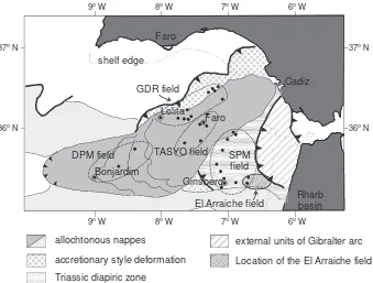
Since the first mud volcano was discovered in the Gulf of Cadiz in 1999 (Gardner, 2000, 2001), 30 or more mud volcanoes were identified in the span of three years (Pinheiro et al., 2002; Somoza et al., 2003), together with vast fields of hydrocarbon-de-rived pockmarks and other features related to fluid escape (Barazza and Ercilla, 1996). As such, the Gulf of Cadiz (Fig. 1) has, in a very short time, become one of the prime targets to study these submarine features and the associated sedimentary, biological and bio-chemical processes.
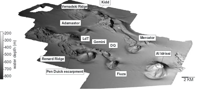
In May 2002 a new mud volcano cluster was dis-covered (Fig. 2) near the Moroccan shelf edge offshore of the city of Larache during a survey with RV Belgica and studied further during Leg 2 of the TTR 12 survey on board of RV Prof Logachev. The El Arraiche mud volcano cluster (Fig. 2) consists of 8 mud volcanoes in water depths from 200 to 700 m. The largest mud volcano in the field (Al Idrissi mud volcano) is 255 m high and 5.4 km wide and the smallest mud volca-noes (Lazarillo de Tormes and Don Quichote mud volcanoes) are only 500 m wide and 25 m high. The surveys yielded detailed multibeam bathymetry over the entire area, dense grids of high-resolution seismic
allochtonous nappes
accretionary style deformation Triassic diapiric zone
external units of Gibralter arc Location of the El Arraiche field
6o W 7o W
8o W 9o W
37o N
36o N
6o W 7o W
8o W 9o W
37o N
36o N
Rharb basin Cadiz Faro
shelf edge
Lolita
Faro
Bonjardim
Ginsberg GDR field
TASYO field
DPM field SPM
field
El Arraiche field
data, a few very high-resolution deep-towed sub-bot-tom profiles, side scan sonar data over the major structures, selected video imagery, video guided grab samples, dredge samples and gravity cores. Integration of data sets allows studying these long-lived mud volcanoes in detail, and moreover, macro as well as micro level studies over selected places from the re-gional scales down to microscopic scales.
Mud volcanoes in the Gulf of Cadiz are closely associated with accretionary wedge-type setting re-lated to the convergence of the African and Eurasian plate boundaries and gravitational thin-skinned tec-tonics over a Triassic salt decollement, also com-monly known as the olistostrome unit (Somoza et al., 2003). The newly discovered El Arraiche field is part of a larger cluster of mud volcanoes (the Span-ish Moroccan Field, Gardner, 2001) that lies within the accretionary realm but outside the active olistos-trome units (Fig. 1). Like other mud volcanoes in the Gulf of Cadiz (Somoza et al., 2002), the El Arraiche mud volcanoes evidence episodic expul-sion of liquidized sediment thought to be related to the episodic migration of hydrocarbons. This paper describes the main characteristics of the mud volcanoes in the El Arraiche field and dis-cusses their origin, structural setting and the impli-cations for the hydrocarbon potential of this area offshore Morocco.
2. Geological setting
The Gulf of Cadiz is situated between 98W to 68 45VW and 348N to 37.15VN enclosed by the Iberian peninsula and Morocco, west of Gibraltar. The ba-thymetry is steadily increasing from 200 m at the shelf edge to depths of over 4 km in the Horseshoe and Seine abyssal plains. Geologically, the setting of the Gulf of Cadiz is extremely complex and still under debate (Sartori et al., 1994; Maldonado et al., 1999; Gutscher et al., 2002). One of the most important structures is the large olistostrome complex (or allochthonous nappes) that were emplaced in the Tor-tonian in an accretionary wedge-type environment (Maldonado et al., 1999; Medialdea et al., 2004). The main part of the olistostrome unit occupies the central part of the Gulf of Cadiz as a lobe-shaped structure that extends over 300 km into the ocean (Fig. 1, Maldonado et al., 1999), its extent seems not yet well defined (Maldonado et al., 1999; Somoza et al., 1999; Medialdea et al., 2004; Maestro et al., 2003). The study area is situated south of the main olistos-trome unit where thick Late Miocene–Pliocene sedi-mentary series were deposited in extensional basins at the back of advancing allochthonous sheets ( Medial-dea et al., 2004). Mio–Pliocene depocentres are bor-dered by shallow ridges characterized by large and active normal faults (Flinch, 1993), probably super-Renard Ridge
Fíuza
Al Idrissi Vernadski Ridge
Gemini
2 KM Kidd
LdT Adamastor
Mercator
DQ
Pen Duick escarpment -800
-700 -600 -500 -400 -300 -200
water depth (m)
Fig. 2. 3D morphology of the El Arraiche mud volcano field at the Morroccan Atlantic margin derived from multibeam bathymetry. Al Idrissi is the largest mud volcano, 255 m high and 5.4 km in diameter. Don Quichote (DQ) and Lazarillo de Tormes (LdT), the smallest mud volcanoes, are only about 25 m high.
posed on relict Miocene thrust anticlines (Maldonado et al., 1999) or Triassic salt diapir structures ( Bera´-stegui et al., 1998; Somoza et al., 2003).
All mud volcanoes and other fluid escape features have been found within the realm of the accretionary prism units. They cluster in several mud volcano fields (Somoza et al., 2003,Fig. 1): the Guadalquivir Diapir Ridge (GDR) mud volcano field is located at the north-western side of the Guadalquivir Ridge at the margin of the Tortonian olistostrome unit and at the main thrust belt in this area. It is a dense field with 11 identified mud volcanoes, mud cones and large fluid escape structures in water depths from 380 to 1560 m (Somoza et al., 2003). The termbmud coneQ
refers to conical shaped hills without proof of mud breccia (Somoza et al., 2003) but is further used here to indicate the mud volcanic hill. The largest structure, the Lolita mud cone, occurs in a water depth of 1560 m and is 316 m high and 5.7 km wide. The Tasyo mud volcano field is separated from the GDR mud volcano field by the Cadiz undercurrent channel. It lies over the north-central part of the main olistostrome unit and consists of 8 mud volcanoes or mud cones amidst many other unidentified circular sea floor structures. The largest structure, the Faro mud volcano, is 190 m high and 2.6 km wide and set in a water depth of 795 m. The Deep Portuguese Margin (DPM) mud volcano field occupies the distal part of the main olistostrome unit in water depths between about 2 to 3.2 km. Only three mud volcanoes have been discovered in this large area but many other features that resemble mud volcanoes or mud cones still need to be studied. The largest in this mud volcano field is probably the Bonjardim mud volcano that was encountered in a water depth of about 3060 m. It is about 100 m high and about 1 km in diameter (Pinheiro et al., 2002). The Spanish-Moroccan (SPM) mud volcano field lies within thebTriassic DiapiricQstructural zone (Somoza et al., 2003), south of the main olistostrome unit, in a water depth of about 600 to 1200 m. The largest structure in this area is probably the Ginsburg mud volcano that is over 200 m high and about 4 km in diameter in a water depth of about 1200 m (Gardner, 2000, 2001).
The El Arraiche mud volcano field is located at the south-eastern continuation of the Spanish-Moroccan mud volcano field, offshore the city of Larache. The mud volcano field is located within the accretionary
prism structure but outside the realm of the main olistostrome units. Exploration well LAR-1 is located about 8 km east of the study area.
3. Data
The multibeam survey on board R/V Belgica used a Kongsberg EM 1002, extended with a deep water module. Maximum sailing speed was 6 knots, with a swath width of 750 m in shallow water (b500 m) and 500 m in deep water. The acquired data was corrected and cleaned with the Kongsberg packages Merlin and Neptune. The footprint at 400 m is 1515 m. In total 700 km2was covered.
A total of 62 high-resolution seismic profiles (Fig. 3) were acquired in three dense grids with a line spacing of about 1 km centred on the Mercator, Al Idrissi and Gemini mud volcanoes. The seismic ac-quisition used a SIG sparker (80 electrodes) with an energy of 500 J and a SIG surface single channel streamer. In some cases a water gun (15 in.3) or a GI-gun (SODERA 35 in.3 generator and 35 in.3 in-jector) were used. Along 5 lines the IFREMER deep-tow Chirp source (650–2000 Hz) was tested with the IFREMER deep-tow 2-channel streamer (of which only one channel was used during this campaign), with excellent results in terms of penetration and resolution. Seismic profiles were digitally recorded using the Elics Delph system. Data processing (swell-filter, band pass filter, deconvolution and signal amplification) used the Landmark Promax processing software. Interpretation and mapping was done using Seismic Microsystems’ Kingdom Suite.
Idrissi mud volcanoes. In the craters of the main mud volcanoes (Mercator, Al Idrissi, Gemini, and Fiu´za) the subsurface was sampled by gravity cores. Four additional box cores are also available from the R/V Belgica survey. The technical details of the equipment and core analysis strategies during TTR12 survey are listed in the cruise reportKenyon et al. (2003). Geo-chemical sampling was performed on all gravity cores within the El Arraiche mud volcano field at irregular intervals of about 10 to 30 cm, depending on the lithology. Geochemical sampling and analysis proce-dures are described by De Mol et al. (1998) and
Stadnitskaia et al. (2002). This paper uses measure-ments of methane concentrations and the ratio between methane concentration and the concentration in high hydrocarbons (C1/C2+).
4. Data description and interpretation
The El Arraiche mud volcano field (Fig. 2) con-sists of at least 8 mud volcanoes of varying size that are clustered around two sub-parallel sea floor ridges, the Vernadsky and Renard ridges, both with steep fault escarpments. The ridges rise up in water depths of about 700 m and stretch to the shelf edge. Most mud volcanoes occur on top of the Renard ridge (Lazarillo de Tormes mud volcano, Gemini mud volcano, Don Quichote mud volcano and Fiu´za mud volcano). The Kidd mud volcano is situated on top of the Vernadsky Ridge. Isolated mud volcanoes occur between the ridges (Adamastor mud volcano, Mercator mud volcano, Al Idrissi mud volcano).
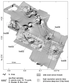
Fig. 3. Shaded bathymetry map of the El Arraiche mud volcano field with localisation of the available seismic data, side scan sonar mosaics, TV-lines, and sea floor samples.
0 km 2
1 0.5
sec TWT
Pen Duick escarpment
East Fíuza mv
Al Idrissi mv
WNW ESE
West Gemini mv
basal unconformity
change in track change in track
moat axis mud flows mud
flows moat see inset
detail of Fíuza mud volcano
Fig. 4. General high-resolution seismic line (sparker source) over Al Idrissi, Fiu´za and Gemini mud volcanoes. The mud volcanoes are characterized by a reflection-free seismic facies that shows stacked outflow lenses within a stratified series of hemi-pelagic sediments above a regional unconformity. The inset shows a detail of interfingering mud flows that accumulate in moats at the base of the Fiu´za mud volcano cone.
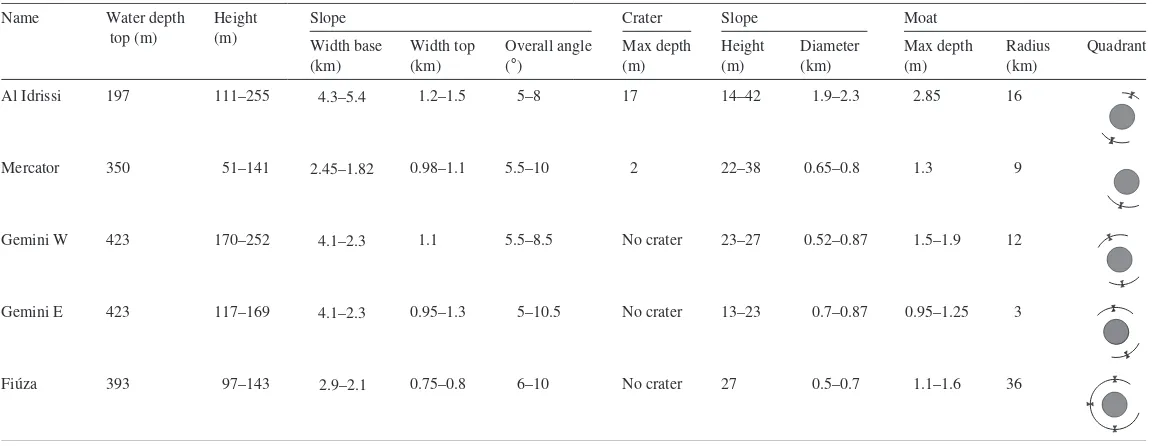
Table 1
General morphological characteristics of the main mud volcanoes of the El Arraiche field
Al Idrissi Name Water depth
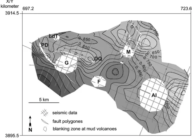
The mud volcanoes stand out as conical hills on the sea floor with varying slope profiles (Van Rensbergen et al., 2005), mud breccia deposits were found at their top. On the seismic data, the mud volcanoes are characterized by a reflection-free seismic facies that shows stacked outflow lenses within a stratified series of hemi-pelagic sediments above a regional unconfor-mity (Fig. 4). This basal unconformity is mapped in
Fig. 5and is used to document the structural setting of the mud volcanoes. The following paragraphs will describe each of the mud volcanoes. Statistical and descriptive information on the mud volcanoes can be found inTable 1.
4.1. Al Idrissi mud volcano
Al Idrissi mud volcano is the largest and shallowest mud volcano in the field, situated just below the shelf edge in water depths of about 420 m (Fig. 2). It appears to be located on a westward plunging anti-cline (Fig. 5), visible in the bathymetry and on seismic data at the eastern side of the Al Idrissi mud volcano but almost entirely disappears at its western side. Deep moats at the base occur at the northern and southern side of the mud cone but they are absent over the plunging anticline at the western and eastern sides. The mud volcano is 225 m high, up to 5.4 km wide at its base and 1.5 km wide at the top (Table 1). It is almost circular at the base and has an eye-shaped crater at the top. The crater is up to 17 m deep at the western side, the eastern part is occupied by a central dome-shaped elevation, maximum 42 m above the crater floor. The flanks of the mud volcano are dom-inated by down slope mud flows. On the side scan sonar mosaic (Fig. 6), mud flows have an even texture but return high backscatter in contrast to the pelagic slope sediments. Backscatter contrast is lower on the southern and eastern flanks probably where pelagic sediments drape the mud extrusions. Core 411G (Fig. 7) and box cores B1 and B2 at the top and at the northern flank of the central dome reveal a sandy layer at the surface of 3–5 cm thick with a sharp and irregular limit separating it from a mud breccia. In core 411G (Fig. 7) this mud breccia is a stiff struc-tureless clay with claystone clasts up to 1 cm. The small clasts encountered at the central dome is in contrast with rock clasts found at the crater floor. Here, up to 0.5 m large rocks were dredged. They
are mainly of Upper Miocene and Pliocene age and composed of coarse to fine grained sandstones and siltstones, some with biodetritus in a calcite cement (Akhmanov et al., 2002).
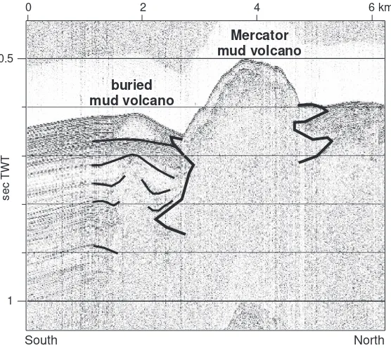
4.2. Mercator mud volcano
The Mercator mud volcano is set at the southern flank of the Vernadsky Ridge within a 2 km wide, N–S oriented, collapse zone. This collapse zone is L-shaped and turns 90 degrees west, north of the Mercator mud volcano (Figs. 2 and 5). The mud volcano is an asym-metric mud volcano (Fig. 8) with a moat along its southern and western side. It is 141 m high at the southern side, 90 m high at the northern side and only 51 m high at its eastern side (Table 1). It has a maximum diameter of 2.45 km at the base and 1.1 km at its top. Side scan sonar data show a semi-concentric pattern related to the fronts of mud flow lobes, rather -6.58
than a radial outward mud flow pattern. A 2 m deep rimmed crater occurs at the northern side but is absent at the southern side. The top of the mud volcano con-sists of a crater and a 38 m high central dome. Solitary blocks (F10 cm in diameter) occur. Core 408 (Fig. 7) yielded a grey, structureless, slightly silty clay with clay stone clasts, covered by 8 cm of oxidized marl. The seismic data (Fig. 9) show a smaller buried structure, interpreted as a buried mud volcano occurs south of Mercator mud volcano within the same collapse zone.
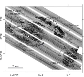
4.3. Gemini mud volcano
The Gemini mud volcano occurs south of the large fault escarpments at the sea floor that bound the south-ern flank of the Renard Ridge (Fig. 2). It consists of two mud volcanoes in one large oval-shaped mud cone (Fig. 10). The entire mud volcano is up to 252 m high, 4.1 km long to 2.3 km wide at the base, the maximum diameter at the top of the eastern part (Gem-ini East) is 1.3 km and the maximum diameter of the western part (Gemini West) is 0.9 km (Table 1). The summits of both Gemini East and Gemini West consist of a flat crater area with a central dome of respectively
23 and 27 m above the flat crater area. Core 404G at the eastern summit (Fig. 7) reveals 12 cm of bio-turbated marl (hemi-pelagic mud), on top of different layers of mud breccia. Another marl layer with a thickness of 4 cm occurs at 32 cm depth. The mud breccia is gray and very gas-saturated, with randomly distributed rock clasts. At the western summit is no hemi-pelagic sed-iment. Core 405G (Fig. 7) shows a gray mud breccia with a strong H2S smell. The surface layer (11cm) is an
oxidized, heavily bioturbated mud breccia. Moats are present parallel to the long axis of the mud volcano.
4.4. Other mud volcanoes
Fiu´za mud volcano is a smaller mud volcano east of Gemini (Fig. 10). It is located at the western termina-tion of the Renard Ridge and possibly at the southern continuation of the collapse depression that host the Mercator mud volcano but no faults could be traced in either direction to its location. The mud volcano is maximum 143 m high, 2.2 km wide at the base and has a flat top of up to 0.75 km wide with a central dome of
Al Idrissi Mercator Gemini East Gemini West
Depth (cm) up to 3.5 cm in diameter
very porous clay matrix, porosity increasing
very stiff very porous
matrix Marl with silt and pebbles
Sand with pebbles Mud Breccia
(Oxidized)
Fig. 7. Description of gravity cores located at the crests of the main mud volcanoes. The localisation of the cores is indicated onFig. 3. Cores have widely varying fluid contents. Inactive mud volcanoes are covered by a hemi-pelagic drape.
homogeneous mud breccia covered by 12 cm of pe-lagic marl. A semi-circular moat occurs around the base of the mud volcano. Moats are also prominent at deeper levels on seismic data.
Kidd and Adamastor mud volcanoes have been described earlier by Gardner and Shashkin (2000). Adamstor is 2 km wide at the base and about 160 m high. Kidd is sitting on the edge of a fault escarpment, it is about 4 km wide but its height is difficult to measure (between 60 to 160 m). The smaller Don Quichote and Lazarillo de Tormes mud volcanoes occur at the crest of fault blocks on top of the Renard Ridge. Lazarillo de Tormes mud volcano, is 500 m wide and 25 m high. No cores were taken at these mud volcanoes. In general, both mud volcano setting seem associated with extensional faults at the crest of the Renard Ridge anticline.
4.5. Interpretation
On seismic sections, the mud volcanoes consist of a columnar zone without coherent acoustic informa-tion, about the width of the mud volcanic cone (Fig. 4). Large mud flows emerging from this central zone are also free of reflections, but show a sharp
transi-0.5
1
2 4 6 km
sec
TWT
0
Mercator mud volcano
buried mud volcano
South North
Fig. 9. Seismic line through the Mercator mud volcano and a smaller buried mud volcano just south of it. crater
410D
409D
central dome 408G
moat
35.31
o
N
35.3
35.29
-6.66 oW -6.65 -6.64 -6.63 1 km
-400
-450
tion to the surrounding sediments. The mud flow deposits are typically lens-shaped, convex at the top and often fill a moat at the base of the mud volcano. In the subsurface, the same pattern returns at several levels bounded by local unconformities (Fig. 4). Stacked outflow lenses produce the typical Christmas-tree morphology of long-lived mud volca-noes, similar to other mud volcanoes in the Gulf of Cadiz (Somoza et al., 2002). On the seismic data only the tips of the largest outflow deposits are visible and probably represent only the largest extru-sion events. The lateral dimenextru-sions of feeder channel and outflow deposits in the subsurface cannot be measured due to acoustic blanking under almost the entire width of the present-day mud volcano. 3D seismic data in other mud volcanic provinces have demonstrated that the width of the feeder chan-nel is probably much smaller than the zone affected by acoustic blanking or by chaotic reflections (Van Rensbergen et al., 1999).
Moats at the base of mud volcanoes are mostly interpreted as subsidence rims related to volume
reduc-tion caused by degassing and sediment removal (Prior et al., 1989; Camerlenghi et al. 1995). However, high-resolution seismic profiles across these moats show the details of a cut-and-fill facies, indicating erosion by currents. Somoza et al. (2002) also suggest that the moats are caused by erosional currents deflected by the mud volcano cone. For the El Arraiche mud volca-no field,Van Rensbergen et al. (2005)suggest erosion in combination with subsidence; subsidence rims can be deepened by current or smoothed by sediment fill. The subsidence rims do not evolve into sediment with-drawal synclines but are filled by mud flows and lay-ered hemi-pelagic sediments and re-appear higher in the section at a slightly different position.
Episodic mud extrusion created vertical columns of remoulded mud up to 500 m below the top of the mud volcanoes. The deepest observed occurrence of mud extrusion deposits is underlain by a regional unconfor-mity. The unconformity, between 450 and 1250 ms TWT (or about 350 and 900 m below sea level), bears witness to a wide-spread erosional event and is the base for a seemingly continuous succession of deep
moat
403G
Gemini mv
Fiuza mv
Don Quichote mv escarpments
405G 404G
Penn Duick escarpment
6.78 oW 6.74 6.7
35.3
35.28
35.26
o
N
2 km
-500
-500
-500
-600
-500
Fig. 10. Side scan sonar mosaic over the Gemini and Fiu´za mud volcanoes with superimposed bathymetry. The entire mud volcano is about 200 m high, 4.88 km long to 2.5 km wide at the base, the diameter at the top of the eastern part is 0.9 km and the diameter of the western part is 0.6 km. The summits consist of a flat area with a central dome of respectively 20 and 30 m above the flat top. Fiu´za mud volcano is 60 m high, 2.2 km wide at the base and has a flat top of about 600 m wide with a central dome of 10–18 m high and about 300 m wide.
water sediments. This basal unconformity is interpreted to correspond to an important sea level low stand at 2.4 Ma (Herna´ndez-Molina et al., 2002). This estimated date is well within the age limits obtained by correla-tion with a near-by industrial well LAR-1 (Flinch et al., 1996), and yields a reasonable sedimentation rate of about 10 cm/ka. The interpreted age (2.4 Ma) of the regional unconformity can be regarded as an upper estimate for the duration of the mud volcano activity in the El Arraiche field.
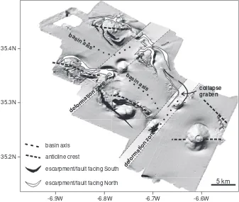
The time–structure map of this basal unconformity (Fig. 5) shows the structural highs and younger normal faults at the crests. Fault interpretation from the seismic sections is difficult due to the fact that data quality at the mud volcanoes and ridges is not optimal. The bathym-etry data show much better the geombathym-etry of active faults. Steep escarpments are drawn from sea floor dip maps on the shaded relief map of the study area together with structural information from the seismic
data in Fig. 11. Numerous extentional faults create steep escarpments, in places more than 100 m high, with rapidly varying strike. They are interpreted as collapse faults related to the uplift of the anticlines. Also the Vernadsky Ridge and Renard Ridge anticlines are not continuous structures but appear almost as an
den-echellonTsuccession of curved sections, disrupted by 2–3 km wide NW–SE trending deformation zones. From the seismic data, it appears that these deformation zones are associated with increased subsidence and collapse of the anticlines.
5. Discussion
5.1. Origin of El Arraiche mud volcano field
There is little information about the deep-seated feeder system of the El Arraiche field. High-resolution
35.4N
35.3N
35.2N
-6.9W -6.8W -6.7W -6.6W
5 km ba
sin axis basin axis
collapse graben
e n o z n o it a m r o f e d
e n o z n o it a m r o f e d
escarpment/fault facing South
escarpment/fault facing North basin axis
anticline crest
seismic profiles only penetrate the upper 500 m and in this case only image the extrusive part of the mud volcano system. Moreover, the subsurface immediately below the mud volcanoes is almost entirely blanked. Only mud breccia clasts from the mud volcanoes bear witness of the stratigraphy that was traversed by the mud volcano feeder system. Petrographic studies of mud breccia clasts retrieved from Al Idrissi and Mer-cator mud volcanoes byAkhmanov et al. (2002)situate the mud volcano field over an Upper Miocene–Plio-cene sedimentary basin. Smaller limestone clasts indi-cate that the mud volcano feeder system probably roots in or below Upper Cretaceous–Miocene rocks, similar to the other mud volcano fields in the Gulf of Cadiz (Akhmanov et al., 2002; Ovsyannikov et al., 2003). Upper Miocene–Pliocene clasts were of exception-ally large size, which indicates the shallow position of Upper Miocene–Pliocene rocks in this area. On basis of the near-by exploration well LAR-1 and its corre-lation with industrial 2D seismic lines (Flinch, 1993), the top Pliocene and top Miocene at the Al Idrissi mud volcano are estimated to occur respectively at about 150 and 900 m below the sea floor. The base of the Upper Miocene was not encountered in the 2400 m deep LAR-1 drill hole. Hence, the distance of vertical transport of the large blocks ranges from 370 m (the depth to top Pliocene plus the height of the mud volcano) to over a kilometre.
The source of overpressure seems to be, at least partly, related to pore fluid volume expansion during thermogenic gas generation (Barker, 1990). The large mud volcanoes (Al Idrissi, Gemini, Mercator and Fiu´za) bears witness of repetitive sediment extrusion
and growth since they appeared about 2.4 Ma ago. Gas generation in Mesozoic source rocks and focussed fluid flow along the basal detachment of the accretionary wedge both provide possible sources for sustained and repeated fluid injection into the overburden sediments, probably increased by periods of tectonic compression. Geochemical analysis of gravity cores on the mud volcanoes (Table 2) yielded hydrocarbon gasses from thermogenic origin in the crater of Gemini West and gasses from mixed thermogenic/biogenic in the craters of Fiu´za and Gemini East mud volcanoes, the latter was interpreted byBileva and Blinova (2002) as evidence for a longer period of inactivity. Hydrocarbon gasses with thermogenic signature were also retrieved from Ginsberg mud volcano, down slope of the El Arraiche field (Mazurenko et al., 2002).
5.2. Mud volcano activity
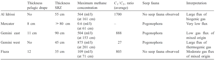
The notion of present-day activity of mud volca-noes depends on whether fluid or sediment expulsion is considered. Both processes occur at mud volcanoes and they are closely related given that fluid flow is the main cause of subsurface sediment mobilisation (see discussion byVan Rensbergen et al., 2003). But both fluid seepage and sediment extrusion activity are dif-ficult to assess and conclusions can diverge as is illustrated below. Table 2summarizes the indications of mud volcano activity for the main mud volcanoes in the El Arraiche field. The time since the last sediment extrusion is indicated by the thickness of hemi-pelagic sediments that cover mud breccia at the crater. Our observations indicate that most recent
Table 2
Overview of indicators of mud volcanic activity. AverageC1/C2+ratio is calculated for the measurements below the sulphate reduction zone
(SRZ)
Al Idrissi No 55 cm 564 (ml/l)
(at 161 cm)
1700 No seep fauna observed Large flux of
biogenic gas
Mercator 8 cm H80 cm 0.6 (ml/l)
(at 61 cm)
– Pogonophora Very low flux
Gemini east 11 cm 90 cm 504 (ml/l)
(at 153 cm)
888 Pogonophora Low gas flux of
mixed origin
Gemini west No 45 cm 875 (ml/l)
(at 201 cm)
27 Pogonophora Large flux of
thermogenic gas
Fı´uza 12 35 cm 109 (ml/l)
(at 71 cm)
803 No seep fauna observed Moderate gas flux
of mixed origin
crater-wide sediment extrusion occurred at Al Idrissi and Gemini West mud volcanoes. At Mercator mud volcano, recent extrusion seems to have occurred only in a narrow zone at the crest of the central dome (Van Rensbergen et al., 2005). The activity of gas seepage can be deduced from the depth of the sulfate reduction zone (SRZ) and by the occurrence of typical seep fauna. Al Idrissi and Gemini West are the most active mud volcanoes; there is no or little pelagic drape, the SRZ is shallowest and the methane concentrations in the sediments are high. It is remarkable that theC1/
C2+ratio at Al Idrissi is typical for biogenic methane
whereas Gemini West has C1/C2+ ratio typical for
thermogenic methane.
5.3. Structural control on mud volcano occurrences and its implications for hydrocarbon exploration
The Vernadsky Ridge anticline and the anticline below Al Idrissi mud volcano continue into the shelf area where they were mapped by Flinch (1993) on basis of regional seismic lines. Flinch et al. (1996)
mapped listric faults over Miocene thrust anticlines that bound large Pliocene extensional basins (Fig. 12). Similar Pliocene extensional basins have been identi-fied on regional seismic lines in the central Gulf of Cadiz (IAM-T3 line in Gracia et al., 2003 and in
Medialdea et al., 2004). They formed at the back of the advancing sheets (Medialdea et al., 2004), proba-bly facilitated by the mobilisation of Triassic evapor-ites and Miocene shales (Maestro et al., 2003).
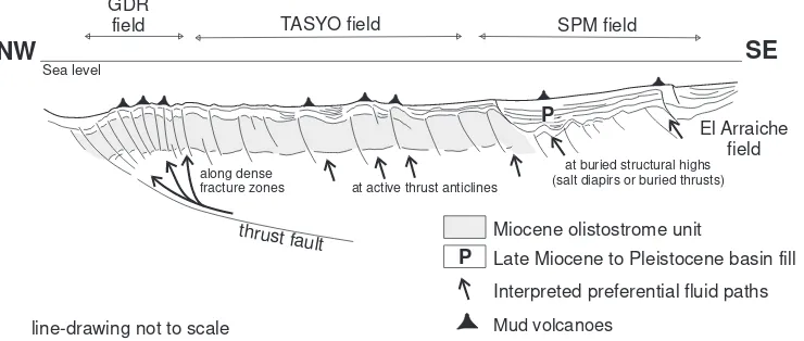
The structural setting of the El Arraiche field is thus very different from the GDR, Tasyo and DPM mud volcano fields in the Gulf of Cadiz and the geographical division in mud volcano fields also has geological relevance. A generalized line drawing along a NW–SE transect illustrates the structural set-ting of the different mud volcano fields (Fig. 12). The GDR mud volcano field is located at the north-west-ern margin of the Tortonian olistostrome and at the major fold and thrust belt in this area (Gracia et al., 2003). Large thrusts faults are known to focus fluid flow at the base of the accretionary system. These fluids are likely to move upwards along stacked steep inverse faults at the front thrust zone (GDR field) or at thrust anticlines within the olistostrome unit (TASYO field en DPM field). At places, mud volcanoes are interpreted to overlie diapirs of Miocene plastic marly clays of the olistostrome unit (Maldonado et al., 1999; Somoza et al., 2003). The olistostrome unit is densely fractured, thrust anticlines are not continuous and very irregular, hence mud volcano distribution seems ran-dom. Pinheiro et al. (2002) indicate that mud volca-noes seemed aligned along a conjugate fault system with NW–SE and NE–SW direction, probably strike-slip faults. In any case, the influence of the intensely deformed allochthonous units on the distribution of mud volcanoes and fluid escape features is dominant. The SPM mud volcano field and the El Arraiche field are located outside the main olistostrome unit. Here, most compressional structures are buried below a thick, continuous, Plio–Pleistocene sequence that
Miocene olistostrome unit
NW
SE
Sea level
thrust fault GDR
field TASYO field SPM field
El Arraiche field
Late Miocene to Pleistocene basin fill
line-drawing not to scale
P
P
Interpreted preferential fluid paths
along dense
fracture zones at active thrust anticlines
at buried structural highs (salt diapirs or buried thrusts)
Mud volcanoes
seals accretionary complex structures of Miocene age (Gracia et al., 2003).
The mud volcanoes seem to be located within extensional fault zones, which facilitate vertical up-ward fluid and sediment injections. The exact location of the mud volcanoes depends on the local and re-gional stress directions. Mercator mud volcano, the buried mud volcano south of Mercator mud volcano, and Fiu´za mud volcano seem to occur within a NE– SW trending deformation zone. Kidd and Adamastor mud volcanoes, and probably a smaller one just south of Adamastor, also appear to occur within a NE–SW oriented deformation zone, almost parallel to the col-lapse depression that host the Mercator mud volcano (Fig. 11). Sediment injections will occur along fault sections or fractures perpendicular to the direction of minimum horizontal stress (Tingay et al., 2003). Since the anticlines are most likely compressional struc-tures, sediment injections are expected to occur along fault zones perpendicular to the anticline.
Hydrocarbon exploitation in the Gulf of Cadiz only occurs at the Spanish shelf where Spain’s largest gas field, the Poseidon field, producedN500 million Nm3 of natural gas in 2002 (Mineco, 2003). The Moroccan and Portuguese margins are largely under explored, only 5 wildcats were drilled at the Portuguese margin in the Algarve basin (IGM, 2003) and 1 at the Mor-occan shelf offshore the city of Larache (ONAREP, 2003). In the entire Gulf of Cadiz only 7 exploration wells were drilled at water depthsN200 m. The main hydrocarbon source rock is Early to Middle Jurassic oil and gas prone shale. Oil generation was estimated to occur since Toarcian times (ONAREP, 2003). The most important reservoir rocks are Jurassic reefal build-ups and Cretaceous deltaic sands. In the deep water areas Tertiairy turbidites and carbonates are considered to be possible reservoir rocks (ONAREP, 2003). Hydrocarbon exploration in the Gulf of Cadiz is hampered by the intense deformation and nappes emplacement since the Tortonian. Mud volcanoes in the entire Gulf of Cadiz seem to root in Cretacous to Miocene rocks (Akhmanov et al., 2002), below or within the olistostrome units. Somoza et al. (1999)
suggest large possible hydrocarbon accumulations below the salt-floored olistostrome units. In the cen-tral part of the Gulf of Cadiz the structural deforma-tion extends up to the sediment surface and controls the distribution of mud volcanoes in the GDR, Tasyo
and DPM mud volcano fields. This may indicate a redistribution of hydrocarbon fluids from deeper sources along several fault-controlled pathways through the allochthonous complex. In the SPM and the El Arraiche mud volcanoes fields, most of accre-tionary wedge thrust anticlines are sealed by a thick Pliocene section and may host considerable hydroca-bon accummulations. The area offshore El Arraiche remains poorly tested for hydrocarbon accummula-tions but seems to have very good potential.
6. Conclusions
The newly discovered El Arraiche field at the Moroccan Atlantic margin, Gulf of Cadiz, consists of 8 mud volcanoes of varying size and shape just below the Moroccan shelf edge. The largest mud volcano, Al Idrissi mud volcano, is 225 m high and 5.3 km in diameter, the smallest observed mud vol-cano is only 25 m high and 500 m wide. The mud volcanoes seem to be associated with extensional faults with quickly varying throw and strike that compartmentalize anticlinal ridges. The anticlines can be traced regionally and bound extensional basins that formed during the Late Miocene.
The El Arraiche mud volcano field is part of a larger cluster of mud volcanoes (the Spanish Moroc-can Field, Gardner, 2001) that lie within the accre-tionary realm but outside the active olistostrome units. This distinction is clear on regional seismic lines (Gracia et al., 2003; Medialdea et al., 2004) but it also has bearings on the composition and the size of rock clasts in the mud volcanoes (Akhmanov et al., 2002). As other mud volcanoes in the Gulf of Cadiz (Somoza et al., 2002), the El Arraiche mud volcanoes are long-lived structures thought to be related to the episodic migration of hydrocarbons. Onset of mud volcanic activity in the El Arraiche field is estimated at about 2.4 Ma. Since the Upper Pliocene, episodic expulsion of liquidized sediment created vertical piles of extruded mud of up to 500 m thick.
The occurrence of large mud volcanoes bears wit-ness of continued overpressure generation at depth, either by in situ oil and gas generation or by focussed flow and accumulation in the area. The activity of the mud volcanoes is indicated by the thickness of hemi-pelagic sediments covering extruded mud breccia, the
occurrence of seep-typical fauna, the degree of mixing between thermogenic and biogenic hydrocarbons, or the depth of the sulphate reduction zone. These indica-tions give variable results. Gemini West and Al Idrissi mud volcanoes are most active, as they lack a hemi-pelagic sediment drape, feature a shallow sulphate reduction zone, high concentrations of methane, and living Pogonophora worms. The ratio of methane con-centration over the concon-centration of higher homologues gives a biogenic gas source in case of the Al Idrissi mud volcano and a thermogenic signature for the Gemini West crater. The eastern twin crater, Gemini East, was the least active, covered by 12 cm of hemi-pelagic mud. Given its structural setting and the evidence of thermo-genic hydrocarbons, the area has promising hydrocar-bon potential but remains untested.
Acknowledgement
The study frames into ESF’s MVSeis and Mound-force projects. The R/V Belgica CADIPOR survey was partly funded by the GOA project Porcupine-Belgica. The survey during TTR 12 was funded by a FWO-Flanders research grant to PVR. PVR is funded by FWO-Flanders. DD and DVR are funded by IWT. The technical and scientific crew of R/V Belgica and R/V Logachev are gratefully acknowledged. The de-ployment of the deep-tow chirp sonar was part of a collaborative venture with IFREMER. The seismic data were interpreted using Seismic Microsystems’ Kingdom Suite with a University Grant. Joan Gardner suggested valuable improvements to the manuscript.
References
Akhmanov, G.G., Ivanoc, M.K., Henriet, J.P., Sarantzev, E.S., 2002. The El Arraiche diapiric field and itsbexoticQ mud volcanic deposits recovered during the TTR-12 cruise in the Gulf of Cadiz, IOC Workshop Report, vol. 187, p. 9.
Barazza, J., Ercilla, G., 1996. Gas-charged sediments and large pockmark features on the Gulf of Cadiz slope (SW Spain). Mar. Pet. Geol. 13 (2), 253 – 261.
Barker, C., 1990. Calculated volume and pressure changes during the thermal cracking of oil to gas in reservoirs. AAPG Bull. 74, 1404 – 1413.
Bera´stegui, X., Banks, C.J., Puig, C., Taberner, C., Waltham, D., Ferna´ndez, M., 1998. Lateral diapiric emplacement of Triassic evaporites at the southern margin of the Guadalquivir Basin,
Spain. In: Mascle, A., Puigdefa´bregas, C., Luterbacher, H., Fernandez, M. (Eds.), Cenozoic Foreland Basins of Western Europe, Geol. Soc. Spec. Publ., vol. 134, pp. 49 – 68. Bileva, E., Blinova, V., 2002. Geochemical characteristics of
hy-drocarbon gasses from mud volcanoes of the Gulf of Cadiz. IOC Workshop Report, vol. 187, p. 12.
Camerlenghi, A., Cita, M.B., Dellavedova, B., Fusi, N., Mirabile, L., Pellis, G., 1995. Geophysical evidence of mud volcanism on the Mediterranean Ridge. Mar. Geophys. Res. 17 (2), 115 – 141. De Mol, B., Stadnitskaya, A., Swennen, R., Belenkaya, I., Cave, R., 1998. Geochemical sampling. In: Kenyon, N.H., Ivanov, M.K., Akhmetzhanov, A.M. (Eds.), Cold Water Carbonate Mounds and Sediment Transport on the Northeast Atlantic Margin: Preliminary Results of Geological and Geophysical Investigations During the TTR-7 Cruise of R/V Professor Logachev in Co-operation with the CORSAIRES and ENAM 2 Programmes, July–Aug. 1997, IOC Technical Series, vol. 52. UNESCO, pp. 15 – 20.
Flinch, J.A. 1993. Tectonic evolution of the Gibraltar Arc. Unpub-lished PhD thesis, Rice University, Houston.
Flinch, J.A., Bally, A.W., Wu, S., 1996. Emplacement of a passive margin evaporitic allochton in the Betic Cordillera of Spain. Geology 24, 67 – 70.
Gardner, J.M., 2000. Gulf of Cadiz/Moroccan margin, mud diapir-ism and mud volcandiapir-ism study, introduction and geological setting. In: Kenyon, N.H., Ivanov, M.K., Akhmetzhanov, A.M., Akhmanov, G.G. (Eds.), Multidisciplinary Study of Geo-logical Processes on the North East Atlantic and Western Medi-terranean Margins, UNESCO Intergovernmental Oceanographic Commission Technical Series, vol. 56, p. 56.
Gardner, J.M., 2001. Mud volcanoes revealed and sampled on the Western Moroccan continental margin. Geophys. Res. Lett. 28 (2), 339 – 342.
Gardner, J.M., Shashkin, P., 2000. Gulf of Cadiz/Moroccan margin (leg 2). Mud diapirism and mud volcanism study. Side scan sonar. In: Kenyon, N.H., Ivanov, M.K., Akhmetzhanov, A.M., Akhmanov, G.G. (Eds.), Multidisciplinary Study of Geological Processes on the North East Atlantic and Western Mediterranean Margins, IOC Technical Series, vol. 56.
Gracia, E., Danobeitia, J., Verges, J., Bartolome, R., Cordoba, D., 2003. Crustal architecture and tectonic evolution of the Gulf of Cadiz (SW Iberian margin) at the convergence of the Eurasian and African plates. Tectonics 22 (4), 1033.
Gutscher, M.A., Malod, J., Rehault, J.P., Contrucci, I., Klingelhoefer, F., Mendes-Victor, L., Spakman, W., 2002. Evidence for active subduction beneath Gibraltar. Geology 30 (12), 1071 – 1074. Herna´ndez-Molina, F.J., Somoza, L., Vazquez, J.T., Lobo, F., Ferna´ndez-Puga, M.C., Llave, E., Daı´z-del Rı´o, V., 2002. Quaternary stratigraphic stacking patterns on the continental shelves of the southern Iberian Peninsula: their relationship with global climate and palaeoceanographic changes. Quat. Int. 92, 5 – 23.
IGM 2003.http://www.igm.ineti.pt/departam/npep/default.htm. Kenyon, N.H., Ivanov, M.K., Akhmetzhanov, A.M., Akhmanov,
Logachev, June–August 2002, IOC Technical Series, vol. 67. UNESCO (156 pp.).
Maestro, A., Somoza, L., Medialdea, T., Talbot, C.J., Lowrie, A., Vazquez, J.T., Diaz-del-Rio, V., 2003. Large-scale slope failure involving Triassic and Middle Miocene salt and shale in the Gulf of Cadiz (Atlantic Iberian Margin). Terra Nova 15, 380 – 391. Maldonado, A., Somoza, L., Pallare´s, L., 1999. The betic orogen and the Iberian–African boundary in the Gulf of Cadiz: geolog-ical evolution. Mar. Geol. 155, 9 – 43.
Mazurenko, L.L., Soloviev, V.A., Belenkaya, I., Ivanov, M.K., Pinheiro, L.M., 2002. Mud volcano gas hydrates in the Gulf of Cadiz. Terra Nova 14, 321 – 329.
Medialdea, T., Vegas, R., Somoza, L., Va zquez, J.T., Maldonado, A., Diaz-del-Rio, V., Maestro, A., Cordoba, D., Fernandez-Puga, M.C., 2004. Structure and evolution of the
ddOlistostromeTTcomplex of the Gibraltar Arc in the Gulf of Ca´diz (eastern Central Atlantic): evidence from two long seis-mic cross-sections. Mar. Geol. 209, 173 – 198.
Mineco 2003.http://www.cne.es/documentos/petroleo/estadisticas/. ONAREP 2003.http://www.onhym.com/onarep/.
Ovsyannikov, D.O., Sadekov, A.Yu., Kozlova, E., 2003. Rock fragments from mud volcanic deposits of the Gulf of Cadiz: an insight into the Eocene–Pliocene sedimentary succession of the basin. Mar. Geol. 3273, 1 – 11.
Pinheiro, L.M., Ivanov, M.K., Sautkin, A., Akhmanov, G., Magal-ha˜es, V.H., Volkonskaya, A., Monteiro, J.H., Somoza, L., Gard-ner, J., Hamouni, N., Cunha, M.R., 2002. Mud volcanism in the Gulf of Cadiz: results from the TTR-10 cruise. Mar. Geol. 3269, 1 – 21.
Prior, D.B., Doyle, E.H., Kaluza, M.J., 1989. Evidence for sedi-ment eruption on deep-sea floor, Gulf of Mexico. Science 243, 517 – 519.
Sartori, R., Torelli, L., Zitellini, N., Peis, D., Lodolo, E., 1994. Eastern segment of the Azores–Gibraltar line (central-eastern Atlantic): an oceanic plate boundary with diffuse compressional deformation. Geology 22, 555 – 558.
Somoza, L., Maestro, A., Lowrie, A., 1999. Allochtonous Blocks as Hydrocarbon Traps in the Gulf of Cadiz. Offshore Technology Conf. Proc. OTC-12202, pp. 571 – 577.
Somoza, L., Gardner, J.M., Diaz-del-Rio, V., Vazquez, J.T., Pin-heiro, L.M., Herna`ndez-Molina, F.J.the TASYO/Anastasya ship-board parties, 2002. Numerous methane gas-related sea floor structures identified in the Gulf of Ca´diz. EOS, p. 541. Somoza, L., Dı´az-del-Rı´o, V., Leo´n, R., Ivanov, M.,
Ferna´ndez-Puga, M.C., Gardner, J.M., Herna´ndez-Molina, F.J., Pinheiro, L.M., Rodero, J., Lobato, A., Maestro, A., Va´zquez, J.T., Med-ialdea, T., Ferna´ndez-Salas, L.M., 2003. Seabed morphology and hydrocarbon seepage in the Gulf of Ca´diz mud volcano area: acoustic imagery, multibeam and ultra-high resolution seismic data. Mar. Geol. 195, 153 – 176.
Stadnitskaia, A., Blinova, V., Poludetkina, E., 2002. Hydrocarbon gas sampling. In: Kenyon, N.H., Ivanov, M.K., Akhmetzhanov, A.M., Akhmanov, G.G. (Eds.), Geological Processes in the Mediterranean and Black Seas and North East Atlantic; Prelim-inary Results of Investigations during the 11th Training-Through-Research (TTR-11) Cruise of RV Professor Logachev, July–September, 2001, IOC Technical Series, vol. 62. UNESCO, pp. 34 – 39.
Tingay, M.R.P., Hillis, R.R., Morley, C.K., Swarbrick, R.E., Okpere, E.C., 2003. Pore pressure/stress coupling in Brunei Darussalam—implications for shale injection. In: Van Rensber-gen, P., Hillis, R.R., Maltman, J., Morley, C.K. (Eds.), Subsur-face Sediment Mobilisation, Special Publication of the Geological Society of London, vol. 216, pp. 369 – 379. Van Rensbergen, P., Morley, C.K., Ang, D.W., Hoan, T.Q., Lam,
N.T., 1999. Structural evolution of shale diapirs from reactive rise to mud volcanism: 3D seismic data from the Baram delta, offshore Brunei Darussalam. J. Geol. Soc. Lond. 156, 633 – 650.
Van Rensbergen, P., Hillis, R.R., Maltman, J., Morley, C.K., 2003. Subsurface sediment mobilization, introduction. In: Van Rensbergen, P., Hillis, R.R., Maltman, J., Morley, C.K. (Eds.), Subsurface Sediment Mobilisation, Special Publication of the Geological Society of London, vol. 216, pp. 1 – 8.
Van Rensbergen, P., Depreiter, D., Pannemans, B., Henriet, J.P., 2005. Seafloor expression of sediment extrusion and intrusion at the El Arraiche mud volcano field, Gulf of Cadiz. J. Geophys. Res. 110 (F2), F02010. (24 May).