SURVEY METHODS FOR EARTHQUAKE DAMAGES IN THE “CAMERA DEGLI
SPOSI” OF MANTEGNA (MANTOVA)
E. Fratus de Balestrini a, M. Ballarin a, C. Balletti a, V. Buttolo a, C. Gottardi b, F. Guerra a, S. Mander a, L. Pilot a, P. Vernier a
a
Laboratorio di Fotogrammetria, Sistema dei Laboratori, Università Iuav di Venezia, Santa Croce 191, 30135 Venezia, Italy - (edebalestrini, martinab, balletti, buttolo, guerra2, vernier)@iuav.it
b
KEY WORDS: Earthquake, Laser scanner, Cultural Heritage, Camera degli Sposi, Mantegna
ABSTRACT:
Cultural Heritage constitutes a fundamental resource for all Countries, even in economic terms, as it can be considered an extraordinary tourist attraction. This is particularly true for Italy, which is one of the Countries with the richest artistic heritage in the world. For this reason, restoration becomes an essential step towards the conservation and therefore valorisation of architecture. In this context, this paper focuses on one of the first stages that allow us to reach a complete knowledge of a building. Because of the earthquake of May 2012, the Castle of San Giorgio in Mantova (Italy) presented a series of structural damages. On the occasion of its upcoming re-opening to the public, the Soprintendenza per i Beni Architettonici e Paesaggistici per le province di Brescia, Cremona e Mantova has requested an analysis and evaluation of the damages for the development of an intervention project.
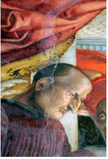
In particular, a special attention was given to the “Camera degli Sposi” ("Bridal Chamber"), also known as the Camera picta
("painted chamber"). It is a frescoed room, with illusionistic paintings by Andrea Mantegna, located in the northeast tower of the Castle. It was painted between 1465 and 1474 and commissioned by Ludovico Gonzaga, and it is well-known for the use of trompe l'oeil details and for the decoration of its ceiling.
The seismic shakes damaged the wall decorated with the “Scena della Corte” (“Court Scene”), above the chimney, re-opening an old crack that had to be analysed, in order to understand whether the damage was structural or just superficial. The diagnostic analyses constitute a fundamental prerequisite for the elaboration of any kind of intervention or restoration in any architectural, artistic or archaeological framework.
To obtain a description of the conservation state of the Camera, non-invasive integrated survey techniques were applied. The purpose of the study presented here is the definition of a methodology able to support the necessity of a rapid restoration. In order to acquire the useful data for the damage evaluation, we used three different kinds of laser scanners. These were chosen according to the dimension of the object that had to be surveyed. The first is Riegl LMS-Z390i, a time of flight laser scanner that was used to survey the external surface of one of the fronts of the Castle. The second one is Faro Focus 3D, a phase-based scanner, used for the indoor survey of the “Camera degli Sposi” and the touristic path from the “Scalone di Enea” to the Camera itself. Finally, a triangulation laser scanner, Konika Minolta Vivid VI-9i, was used to measure the dimension of the crack, for its whole length. All the data acquired by these scanners were georeferenced in the same reference system, defined through a topographic network.
The data collected were processed in order to obtain a number of representations, both in two and three dimensions, useful for a complete knowledge of the state of condition of the building.
This paper analyses the surveying process in all its different phases: from the planning, to the data collection, and the post-elaborations.
1 . INTRODUCTION
1.1 The Emilian earthquake and the damages in the Castello di San Giorgio in Mantova
On 20th and 29th of May 2012, two powerful earthquakes struck northern Italy. The epicentres were recorded respectively in Finale Emilia (magnitude 5.9 Ml) and Medolla (magnitude 5.8 Ml) in the province of Modena though the earthquake was formed by a series of seismic shakes located in the district of the Emilian Po Valley, mainly in the provinces of Modena, Ferrara, Mantova, Reggio Emilia, Bologna and Rovigo.
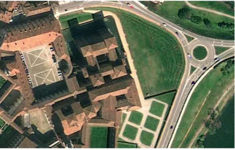
Many monuments in the city of Mantova were hit by the earthquake and, among these, Palazzo Ducale and the contiguous Castello di San Giorgio. These two monuments, the most famous of the city, were so damaged that they had to partially close the palace and totally close the castle. Inside the castle, the "Camera degli Sposi" or "Camera Picta" has raised particular concern, due to the presence of frescoes realised by Andrea Mantegna between 1465 and 1474.
Figure 1. The Palazzo Ducale and the Castello di San Giorgio
to the reopening of a previous injury, probably caused by an earthquake occurred in the past. The concern rose from the fact that the fall of plaster had led to the loss of some parts of the ancient fresco and by the fact that it was not clear whether the crack was superficial or it involved the wall structure of the tower.
Figure 2. The Camera degli Sposi
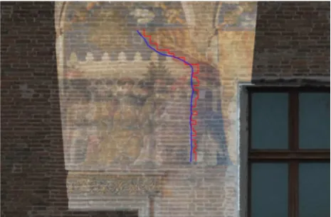
Figure 3. Detail of the crack
Immediately after the earthquake, the Soprintendenza per i Beni Architettonici e Paesaggistici per le province di Brescia, Cremona e Mantova requested an analysis and assessment of the damage in order to proceed with the development of an intervention project. This initial phase turned out to be very important not only from the point of view of the recovery of the architectural and artistic heritage but also because the city's economy is based primarily on tourism. The closure of one of the most important monuments of Mantova has led to a significant and alarming decline in the government income.
1.2 Purpose of the survey
From the very beginning, the survey was necessary because the primary purpose of the Soprintendenza was the re-opening of the tourist path, from the so-called Scalone di Enea to the Camera degli Sposi. All along this path, significant structural damages can still be seen: for this reason it was essential to perform geometric and metric analyses to better project the necessary security measures of all the rooms.
For this occasion, the Laboratory of Photogrammetry carried out a survey campaign integrating topography and different laser scanners, considering different scales of representation, primarily to assess whether the crack of the Camera degli Sposi was structural or not, and secondly, to provide technical documentation needed for the safety draft of the route that had to be re-opened to visitors.
Figure 4. Plan of the surveyed rooms
2 . THE SURVEY
2.1 Tools
Given the complexity of the location and the different sizes of the objects to be surveyed (external walls of the tower, rooms, cracks) different acquisition tools where chosen on the basis of their different precisions.
The reference system for the whole survey was determined by creating a closed loop with a topographic Total Station Leica TCR 1103.
This operation has allowed the definition of a topographic net that, during the data processing phase, allowed the georeferencing of all the scans obtained with different laser scanners into a single reference system.
Regarding data acquisition with laser scanner, three different instruments were used:
- Riegl LMS-Z 390i, a Time of Flight, long-range terrestrial laser scanner. It was used to acquire three-dimensional data on the external parts of the castle’s walls and in the Camera degli Sposi;
Figure 6. Laser scanner RIEGL, LMS-Z 390i
- CAM2, FARO FOCUS 3D, a phase-based terrestrial laser scanner, used for the scans of all the interiors;
Figure 7. Laser scanner CAM2, FARO FOCUS 3D
- MINOLTA VIVID 9i, a triangulation based laser scanner, used to perform a high accuracy survey of the crack in the Camera degli Sposi.
Figure 8. MINOLTA, VIVID 9i
2.2 Data acquisition
The first work phase consisted in planning and implementing the general network that would allow the georeferencing of all the surveys in the same reference system.
Given the complexity of the survey, we had to use a closed loop consisting of control points materialized on the ground both outside and inside of the Castle: the damage that had to be studied was located on one of the walls of the northern tower, therefore we needed to link the inside and the outside in the same reference system, in order to fully analyse the crack. From the 15 topographic stations, three-dimensional coordinates of all the targets required for the laser scanning survey were detected. The observations were adjusted with least squares method, using MicroSurvey Starnet.
Since the signalization had already been prepared for all instruments, in the later phase of data acquisition the work was carried out by four different teams that worked at the same time. In this way, each team worked independently and it was possible to considerably decrease the time of data acquisition; a fundamental task in an emergency situation.
The first team, working with the total station, established the general topographic reference system and acquired the 3D coordinates of the targets for the laser scanning survey. From every point of the network the coordinates of all visible targets were acquired. In this way, every point has been measured by at least two stations: this is essential to generate visible redundancy in the data.
The second and the third team worked on the survey of the exterior and interior of the tower and the visitors' path, with two laser sensors based on the measurement of distance. Those instruments can be considered as automated total stations that measure horizontal and vertical angles and the distance between tool and surface, allowing the calculation of 3D coordinates of all points detected by the laser on the surface of the object to be scanned.
The second team, with the Riegl laser scanner, focused on the acquisition of three-dimensional data on the external walls of the north tower: 4 scans were performed, in order to define the digital shape in the space of the external surfaces of the tower. With the same laser scanner point clouds for the entire Camera degli Sposi were also acquired.
Figure 9. Point clouds of the external of the castle
detected surface as it mounts a calibrated camera. This allows the association, in addition to the three-dimensional coordinates (X, Y, Z) of every point of the point cloud, also the three informations on the color (R, G, B).
The third team worked with the Faro Focus 3D laser scanner, and performed scans of the path that from of the Scalone di Enea leads to the Camera degli Sposi. Scans of the room itself were also performed. With this tool 24 scans were performed.
Figure 10. Point clouds of the path from the Scalone di Enea to the Camera degli Sposi
This type of instrument uses phase shift measurement technology to measure the distance to a surface: an infrared laser is sent out and, upon contact with the surface, reflected back to the instrument itself. The distance is measured by analysing the shift in the wavelenght of the returning signal. The Faro laser scanner allows distance accuracy up to 2 mm, in an operating range from 0.6 to 120 meters, and can acquire up to 976,000 points per second. It is very light and easily transportable and therefore particularly suitable for fast acquisitions. It is considered a "hybrid laser-photogrammetric scanner", as it offers the opportunity to acquire not only the three observations necessary for the determination of the X, Y, Z coordinates of each point, but also to the R, G, B (radiometric) values corresponding to each measured point.
2.3 The Camera degli Sposi
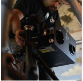
The fourth team performed detailed scans of the damage in the Camera degli Sposi. The scans were performed with the range camera Minolta Vivid 9i, a non-contact tool measurement system based on triangulation.
This kind of range camera is composed by a light source and a sensor plane, which are rigidly bounded. The laser source generates a thin beam of light that produces a bright line on the surface to be measured. Through a sensor device, such as a digital video camera, placed next to the light source, the image of the line of light is captured. In this way, the source, the centre of projection on the sensor and the point of light reflected from the surface form a triangle. If the base (distance between the light source and sensor, which is fixed) and the two base angles are known, all the other parameters can be calculated, and consequently the 3D coordinates of a point on the surveyed surface are acquired.
The camera has three types of lenses: TELE, MIDDLE, WIDE, that can be used depending on the size of the object to be scanned. It has a range that goes from 0.5 to 2.5 m. Depending on the optics used, areas ranging from a size of (x, y, z) were acquired with the Vivid 9i, in order to obtain the complete shape of the damage along the wall and to have a measurement of any deviation from the mean plane of the surface of the area affected by the crack.
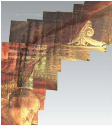
Figure 11. Detail of meshes acquired along the crack
The whole phase of data collection took place over just three days of work, thanks to the presence of the four independent teams that worked at the same time with different tools and aims. This allows the shortening of acquisition time which in this case was essential for two reasons: first, it allows a considerable saving in economic terms, since this kind of survey requires, as seen, many different tools and an adequate number of qualified staff. Secondly, the shortening of working times allows to have much more time to dedicate to the data processing phase, which is necessary to achieve raster or vector representations, that are useful for subsequent evaluation of damage and for the project of first security measures or restoration. Generally, in fact, the time spent to process data, in the laboratory, is much longer than the acquisition phase: all the time saved during the acquisition can be used in the editing and processing data.
3 . DATA PROCESSING
3.1 Registration of the point clouds (Terrestrial Laser Scanners)
After the data collection phase the registration of all the point clouds in the same general reference system given by the topography network was carried out.
Through management software acquisition tools (RiSCAN PRO for Riegl, SCENE for Faro), individual scans were aligned through a methodology known as "georeferencing on target". This methodology requires the use of the topographic data acquired with the total station (the 3D coordinates of the centers of the targets) to record the various clouds of points in the same reference system.
simple text file that contains a list of all the points that make up the cloud. For each point the name of the point itself is indicated (1, 2, 3, etc.), the three coordinates (X, Y, Z), the three radiometric values (R, G, B) and the reflectance value.
At the end of this process the result is a point cloud constituted by millions of points that describes the shape in the space of all surfaces detected in an almost continuous, but in a still discrete way.
Figure 12. Whole point cloud
From this point on, it is possible to extract all the various kind of representations, depending on the purpose of the survey itself.
3.2 Registration of the point clouds (Triangulation based Laser Scanner)
For the scans acquired with the range camera, the georeferencing was performed in a different way. Generally this type of instrument does not require the use of target (they are used only in a few cases with completely smooth or monochrome surfaces) as it uses ICP algorithms (Iterative Closest Point) for the alignment of the recorded meshes. During the data acquisition, as the scans were acquired, a cloud on cloud alignment was performed, using remarkable points or discontinuity of colour on the scanned surfaces. ICP algorithms are able to mimimise point-by-point (given at least three homologous points on two contiguous scans) the distance between the reference surface and the one that is considered as free to move. In this way, at the end of the acquisition phase, all the scans are already aligned in a local reference system. To set this in the global topographic reference system a rototraslation was performed, using 3D coordinates of points taken from point clouds acquired with the terrestrial laser scanner.
3.3 Representations
The work has focused primarily on the Camera degli Sposi and in particular on the damages on the north wall also known as "della Corte".
Since all the scans were registered in the same reference system, it was possible to immediately verify the thickness of the perimeter wall of the tower.
Figure 13. Point cloud of the Camera degli Sposi
Figure 14. Top view of the point clouds
Secondly, orthophotos from the inside and outside walls were overlapped to check if the internal damage had affected the outside area as well: it was soon clear that the damage occurred on a bricked up window on the wall.
Figure 15. Overlapped orthophotos
Because of this, the outer wall was no longer continuous: this caused the earthquake to generate a different movement between the body of the tower and the bricked up window; the previous crack re-opened.
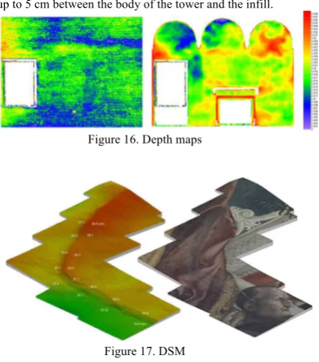
wall, in correspondence to the damage, presented deviations of up to 5 cm between the body of the tower and the infill.
Figure 16. Depth maps
Figure 17. DSM
Two fundamental considerations can therefore be made. The first is that, due to the different behaviour between inside and outside walls, there is definitely a gap. The second consideration concerns the discontinuity of the inner wall: after a careful analysis of the data obtained, it emerged that the damages had not been caused by the earthquake of May 2012, but by an earthquake which occurred in previous centuries. As can be seen in the DSM (Digital Surface Model) obtained from the point clouds, the infill had a forward movement of even 5 cm in the top area, causing significant damage, which was later plastered and repainted. Most probably, the Emilian earthquake just caused a superficial damage to the plaster of the previous crack.
As a result of considerations explained in this research, Mantegna’s fresco has now been restored to its original beauty. For what concerns the path from the Scalone di Enea to the Camera degli Sposi, technicians were provided with orthophotos of plans, fronts and sections, useful for subsequent re-design or analysis of the cracks in the walls.
4 . CONCLUSIONS
The inspection strategy and data analysis used, already tested in previous experiences (Buttolo, 2011), has achieved excellent results in the survey and documentation of the structures in emergency situations that are generally performed in the first phase of post- seismic emergency.
It allows the definition of a standard procedure that can be used in these critical situations, based on the creation of multiresolution morphological maps of deformation (considering of the quantity of damage) obtained by the use of multiple laser scanners with different characteristics and precisions.
With this procedure it is possible, using the data acquired in situ, integrated with thematic restoration analyses, to highlight the damage mechanisms in the structure and to check the hypothesis of damage to establish a protocol for a rapid intervention.
Deformation maps represent a great opportunity for study, especially since there are no previous models to make direct comparisons with. They have the conciseness of a thematic map and can be interpreted in a simple and intuitive way but, at the same time, they are a tool that contains different layers of information useful for different professional applications.
5 . REFERENCES
A. Adami, F. Guerra, P. Vernier, 2007. Laser scanner and architectural accuracy text. XXI International CIPA Symposium, 01-06 October 2007, Athens, Greece
Balletti, C., Guerra, F., Pilot, L., 2006. Integrazione di tecnologie 3d multiscala per la conoscenza, l’interpretazione e la diffusione di un sito archeologico. In: X Conferenza Nazionale ASITA, Federazione delle Associazioni Scientifiche per le Informazioni Territoriali ed Ambientali, Fiera di Bolzano, 14-17 novembre 2006.
Boehler W. 2003 Comparing different laser scanners: features, resolution, accuracy. In CISM, International Centre for Mechanical Sciences, Udine.
Buttolo, V., 2011, Il sisma aquilano: rilievo laser scanner delle architetture e interpretazione dei dati. In:Proceedings of Asita 2011, Parma.
Guidi, G., Russo, M., Beraldin, J.A., 2010, Acquisizione 3d e modellazione poligonale, McGraw-Hill Companies.