isprs archives XLI B8 755 2016
Teks penuh
Gambar
Garis besar
Dokumen terkait
The rich spectral context of the multispectral image is combined with the high spatial resolution of the panchromatic image, applying image fusion – pansharpening, facilitating in
The proposed method of tree growth estimation is based height measurements on point clouds generated from UAV imagery. The achieved accuracy is about
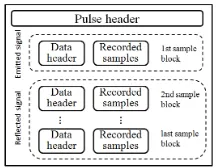
1 provides an overview of the SERAC processes to derive from laser altimetry data and DEMs complex information such as volume and mass balance change rates at individual
This latest reconstruction of GrIS elevation changes consists of 130,000 ice-sheet elevation change time series, spanning 1993- 2014, derived from satellite laser altimetry
Hence, we proposed to integrate multiple spaceborne measurements to study the long-term lake volume changes, including satellite radar altimetry, laser altimetry,
The LKN method consists of the data limiting step (L-step) to reduce dimensionality by applying principal component analysis, a classification step (K-step) to
URBAN ROAD DETECTION IN AIRBORNE LASER SCANNING POINT CLOUD USING RANDOM FOREST
KEY WORDS: Mobile Laser Scanning, Point Cloud, Pavement Crack, Automated Detection, Urban
