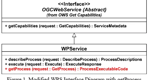
isprsarchives XL 7 W3 643 2015
Teks penuh
Gambar
Garis besar
Dokumen terkait
Finally, figure 6 shows the comparison between the horizontal po- sition of the tide-coordinated shoreline interpolated for the tidal height of the acquisition time of the image
Provided the differences seen in the yearly and daily estimates are in fact related to vegetation changes across the different years, the quality of the soil moisture retrieval
In order to achieve sustainable urban land use and an appropriate provision of ecosystem services, the monitoring of urban vegetation must be reflected against the background
This study is focused on the consistency of SPOT/VGT and PROBA-V GEOV1 products developed in the framework of the Copernicus Global Land Services, providing an
The Main task of matching results representation is to organize and store the related schema elements and the actual mapping between them achieved by schema matching, and to build
The city information from different sources can be integrated into CityGML standard common data model and integrated into a 3D CityDB spatial database, which allows
LARS allows a fine control over the fly height and such allow to take in the same day some global views of the field and very high resolution images on point of interest6. Figure
The resulting procedure, bringing together UAV survey data and geological information on the structural features that generate the hazard, allows for in time monitoring the
