isprsarchives XL 7 W3 1183 2015
Teks penuh
Gambar

Garis besar
Dokumen terkait
Land degradation was assessed by adopting new approach through the integration of GLASOD/FAO approach and Remote Sensing / GIS techniques .The main types of human induced
It means that the fractal dimension of soil pollution in Fukushima nuclear power plant accident corresponded to the one of Abukuma river watershed.. On the other hand, the
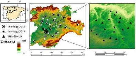
These are the land use map, the map soil morphology and sand cover map (extracted from the map of land) that constitute the basic maps that will serve to establish
In order to assess the geometric accuracy of the stream-based processing system, an accuracy measurement based on pixel correlation between the USGS ’s LPGS
available in regular soil survey reports the use of these properties for defining and mapping ESAs requires the definition of distinct classes with respect to
This study is focused on the consistency of SPOT/VGT and PROBA-V GEOV1 products developed in the framework of the Copernicus Global Land Services, providing an
In the particular case of soil colour the collection of reliable ground data can be cumbersome due to measuring methods, colour communication issues, and other practical factors
In the M 4 Land system, SLC is configured to use spectral configurations and acquisition parameters from the used satellite sensors (in this case RapidEye),
