isprs archives XLI B3 819 2016
Teks penuh
Gambar

Garis besar
Dokumen terkait
Airborne lidar, also known as airborne laser scanning (ALS), has already proven to be a valuable geometric source for facilitat- ing radiometric calibration of hyperspectral
The accuracy of 3D surface reconstruction was compared from image sets of a Metric Test Object taken in an illumination dome by two methods: photometric stereo and
The computed 5.68 m RMSE of AW3D30 is slightly higher than the expected vertical accuracy of the ALOS World 3D which is 5 m (RMSE).The computed mean errors are also slightly higher
In order to deal with aerial images and improve the matching accuracy a novel optical flow field based dense matching methods for aerial image is proposed in this paper, which is
According to the information acquired by Strava Metro, there are more cyclists in suburbs at the centre of Johannesburg and towards the north and to the east, and in Kibler Park
In this study, we compare and contrast estimates of deformation obtained from different pre and post-event airborne laser scanning (ALS) data sets of the 2014 South Napa
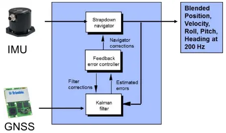
In this study, position uncertainty is computed theoretically without GCPs, and examined every orientation parameters effect on position accuracy with the
an airborne carrier equipped with a suite of hyperspectral sensors and eventually a laser scanner, and further it introduces a pre-processing chain for hyperspectral RS
