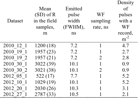
isprsarchives XL 1 W1 145 2013
Teks penuh
Gambar
Garis besar
Dokumen terkait
The connectivity tool was developed to exploit the georeferenced information provided by the Applanix system in constraining feature point extraction to relevant images only,
Lattice Topology Information is the result of grouping Persistent Scatterers to lattices. The two spanning vectors of the lattice have to correspond to the vertical and
Hence, positional or thematic differences between the observed data (e.g. 3D point clouds) and the building model BM i can be caused by the modelling process of building
Apart from using the images of sensor element 1 to derive the exterior camera orientation for reconstructing the spectral data the geospectral camera is able
Such hierarchical approach for building outline detection is proposed by (Gerke et al., 2001), but we use model selection instead of fixed threshold of mini- mum area to be
It is important to understand that the use of smart communication it is necessary to implement the smart city model; in particular the communication between
Challenges of 3D city model visualisation include how to create the 3D scenes for multiple platforms through Internet and how to automatically generate the multiple
Some specific method and techniques are particularly introduced for pixel scale and whole product validation, including the ground observation field selection criteria,
