isprs archives XLI B4 691 2016
Teks penuh
Gambar
![Figure 1. Sample coverage grid types [8]](https://thumb-ap.123doks.com/thumbv2/123dok/3286424.1402984/2.595.307.529.517.598/figure-sample-coverage-grid-types.webp)
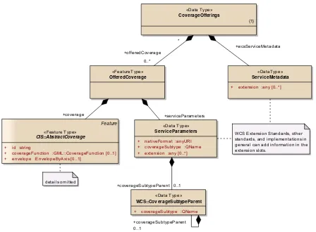
![Figure 2. Coverage Implementation Schema (CIS) 1.1 conformance classes [8]](https://thumb-ap.123doks.com/thumbv2/123dok/3286424.1402984/3.595.334.504.410.549/figure-coverage-implementation-schema-cis-conformance-classes.webp)
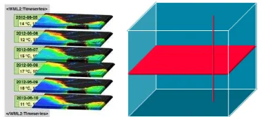
![Figure 4. WCS modular data and service model (source: Wikipedia [35])](https://thumb-ap.123doks.com/thumbv2/123dok/3286424.1402984/4.595.76.518.66.381/figure-wcs-modular-data-service-model-source-wikipedia.webp)
Garis besar
Dokumen terkait
Choosing a landing site with a small landing ellipse is based on the analysis of high- resolution imagery and topographic data as well as mineralogical, elemental,
DENSE IMAGE MATCHING FOR MARS EXPRESS HRSC IMAGERY BASED ON PRECISE POINT PREDICTION METHODX. Lan
The integrated photogrammetric mapping system flown on the last three Apollo lunar missions (15, 16, and 17) in the early 1970s incorporated a Metric (mapping) Camera,
NAIF's WebGeocalc server located at JPL has access to all of the planetary mission SPICE archives hosted there, plus a large set of generic (mission independent) SPICE
Hence we would like to suggest a model where an ontology of indoor space is defined and using this understanding (which is based on geo- metric as well as functional properties of
Through the extended- SensorThings API, users and applications can follow a coherent protocol to control IoT devices that use different communication
The technology then influences the accessibility to data by providing a shared platform (static, cloud), improving the response times to data requests (dynamic, components,
The URBan land recycling Information services for Sustainable cities (URBIS) project aims for the development, implementation, and validation of web-based
