isprs archives XLII 3 W3 39 2017
Teks penuh
Gambar
Dokumen terkait
Photogrammetry was selected to build the above- water model, since images suffice to compute a 3D point cloud, but also to estimate the trajectory of the boat, in order to
The static survey and the NRTK survey were performed using the data from the Italian Continuously Operating Reference Stations (CORS) NetGEO. The GNSS measurements
reference to a point cloud from NIKON D800 data The errors of the point cloud generated from video data relative to the points derived from the high resolution digital
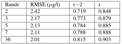
The objective of this study is to investigate the use of high resolution photogrammetric point clouds together with two novel hyperspectral cameras in VNIR and
The point cloud tree extraction techniques operate on TLS data and models the biomass using the estimated stem and canopy volume as inde- pendent variables.. Eight spruce and eight
An exemplary "Color Checker" test object was used, among others, for optical SSI experiments. This was created on the iPad screen mounted on the optical bench in
The classifications using the best combinations of features were more accurate than those using the image-based and point- based features and the combination of
This study compares performance of aerial image based point clouds (IPCs) and light detection and ranging (LiDAR) based point clouds in detection of thinnings and clear cuts
