isprsarchives XL 7 W3 433 2015
Teks penuh
Gambar
Garis besar
Dokumen terkait
Water resources are getting more and more important with each passing day in case of survival of humanity. For this reason, assessing water resources’ quality and also monitoring
To overcome the usual drawback of the low spatial resolution of aerial thermal infrared (TIR) images, resulting from low sensor resolution (here: 640x480 pixel) a
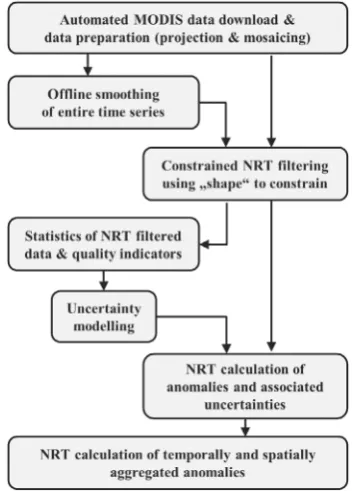
Each of these applications requires detailed and high quality input data from different sources like satellite data, aerial images and ground-based information from
Last, images with the same spatial information but different time series are undergone difference extraction method to understand the changes occurred in an area
KEY WORDS: Image processing, Atmospheric correction, ATCOR, validation, aerosol retrieval, RapidEye,
As part of a Tanzanian-Norwegian cooperation project on Monitoring Reporting and Verification (MRV) for REDD+, 2007-2011 C- and L-band synthetic aperture radar (SAR) backscatter
Satellite radiothermovision is a set of processing techniques applicable for multisource data of radiothermal monitoring of ocean- atmosphere system, which allows
In this study the Feature Extraction toolbox is used to generate the morphological attributes, the method as applied to the recognition and identification of
