isprs archives XLI B7 859 2016
Teks penuh
Gambar
Garis besar
Dokumen terkait
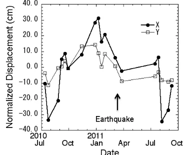
Therefore the COSM O-SkyM ed Himage imagery appear able to guarantee a displacements monitoring with an accuracy of few centimetres using only the amplitude data, provided
The results of the application of a methodology for an integrated orientation into a common reference system using data obtained by LiDAR systems, digital and
To this direction, an iterative methodology was applied in order to combine the process described by Agrafiotis and Georgopoulos (2015) with different pansharpening algorithms
The methodology includes the obtaining of high resolution orthoimages and DSMs which correspond to two or more epochs of the same landslide, the 3D digitizing of common
In this work, we analyze the impact of employing the pixel-wise radiometric and spectral calibration curves on the ability to ex- tract the meaningful signal and filter the noise
The main features of the random forests method that makes it particularly interesting for digital image analysis are that it is unexcelled in accuracy among current algorithms,
The main aim of this paper is to present applied methodology for determining the relationship between exposure parameters of the hyperspectral camera and light
Using the same classification algorithm and classified in the same semantic hierarchy, the relationship of the image quality index and classification accuracy is discussed
