Open Geospatial Consortium
Submission Date: 2014-11-20
Approval Date: 2014-09-14
Publication Date: 2014-12-30
External identifier of this OGC® document: http://www.opengis.net/doc/PER/waterml2.0/part2-ie-results Internal reference number of this OGC® document: 14-114r1
Category: Engineering Report
Editor: Peter Taylor
WaterML2.0
part 2 – rating tables, gauging observations and
cross-sections: Interoperability Experiment Results
Copyright notice
Copyright © 2014 Open Geospatial Consortium
To obtain additional rights of use, visit http://www.opengeospatial.org/legal/.
Warning
This document is not an OGC Standard. This document is an OGC Public Engineering Report created as a deliverable in an OGC Interoperability Initiative and is not an official position of the OGC membership. It is distributed for review and comment. It is subject to change without notice and may not be referred to as an OGC Standard. Further, any OGC Engineering Report should not be referenced as required or mandatory technology in procurements.
Document type: OGC® Public Engineering Report Document subtype:
License Agreement
Permission is hereby granted by the Open Geospatial Consortium, ("Licensor"), free of charge and subject to the terms set forth below, to any person obtaining a copy of this Intellectual Property and any associated documentation, to deal in the Intellectual Property without restriction (except as set forth below), including without limitation the rights to implement, use, copy, modify, merge, publish, distribute, and/or sublicense copies of the Intellectual Property, and to permit persons to whom the Intellectual Property is furnished to do so, provided that all copyright notices on the intellectual property are retained intact and that each person to whom the Intellectual Property is furnished agrees to the terms of this Agreement.
If you modify the Intellectual Property, all copies of the modified Intellectual Property must include, in addition to the above copyright notice, a notice that the Intellectual Property includes modifications that have not been approved or adopted by LICENSOR. THIS LICENSE IS A COPYRIGHT LICENSE ONLY, AND DOES NOT CONVEY ANY RIGHTS UNDER ANY PATENTS THAT MAY BE IN FORCE ANYWHERE IN THE WORLD.
THE INTELLECTUAL PROPERTY IS PROVIDED "AS IS", WITHOUT WARRANTY OF ANY KIND, EXPRESS OR IMPLIED, INCLUDING BUT NOT LIMITED TO THE WARRANTIES OF MERCHANTABILITY, FITNESS FOR A PARTICULAR PURPOSE, AND NONINFRINGEMENT OF THIRD PARTY RIGHTS. THE COPYRIGHT HOLDER OR HOLDERS INCLUDED IN THIS NOTICE DO NOT WARRANT THAT THE FUNCTIONS CONTAINED IN THE INTELLECTUAL PROPERTY WILL MEET YOUR REQUIREMENTS OR THAT THE OPERATION OF THE INTELLECTUAL PROPERTY WILL BE
UNINTERRUPTED OR ERROR FREE. ANY USE OF THE INTELLECTUAL PROPERTY SHALL BE MADE ENTIRELY AT THE USER’S OWN RISK. IN NO EVENT SHALL THE COPYRIGHT HOLDER OR ANY CONTRIBUTOR OF
Contents
1. Scope ... 7
2. References ... 7
3. Terms and Definitions ... 8
3.1 Conversion ... 8
3.2 Control ... 8
3.3 Rating ... 8
3.4 Rating curve ... 9
3.5 Rating table ... 9
3.6 Stage ... 9
3.7 Discharge ... 9
3.8 Gauging/ Gauging Observation (Gaging US) ... 9
3.9 Cross-section ... 9
4. Objectives of the Interoperability Experiment ... 9
4.1 Technical objectives ... 10
4.2 Domain objectives ... 10
5. Summary of key findings ... 10
6. Scenarios ... 11
6.1 Scenario 1 – Inter agency exchange (Australia) ... 11
6.2 Scenario 2 – River Modeling and Flood forecasting (United States) ... 12
6.3 Scenario 3 – Public data publishing (United Kingdom) ... 13
6.4 Scenario 4 – Validation and Visualization ... 14
7. Requirements ... 15
7.1 Ratings ... 16
7.3 Cross-sections ... 16
7.4 Range periods ... 16
8. Service implementation options ... 17
8.1 Services considered ... 17
8.1.1 Sensor Observation Service (SOS) ... 17
8.1.2 Web Feature Service (WFS) ... 17
8.1.3 Representational State Transfer (REST) Service ... 17
8.2 Implementation design ... 17
8.2.1 Ratings - Conversions, ConversionGroups and RangeValues in SOS ... 17
8.2.2 Gaugings in SOS ... 18
8.2.3 Gaugings in WFS ... 19
8.2.4 Cross-sections in SOS/WFS ... 19
8.3 Summary ... 20
8.4 OGC service deployment ... 21
8.5 RESTful service implementation ... 21
8.6 Recommended service implementation ... 22
9. The IE information model ... 22
9.1 Gaugings implementation model ... 24
9.2 Conversions implementation model ... 25
9.3 Vocabularies ... 26
10. Scenario Implementations ... 26
10.1 Australian scenario – cross agency exchange ... 26
10.2 US Scenario ... 28
10.3 UK Scenario ... 28
10.4.1 Visualisation client ... 30
11. JSON encoding ... 32
11.1 Standard JSON response headers ... 32
11.2 JSON Schema ... 33
12. Challenges ... 34
12.1 Mapping to internal data structures ... 34
12.1.1 Identifiers ... 34
12.2 Handling large service responses ... 35
12.3 Separation of information model and web service ... 35
12.3.1 Optimizing API return collections ... 35
13. Results ... 38
i.
Abstract
Part 1 of WaterML2.0 covers exchange of hydrological time-series data, the
observational processes used to generate them, and information related to the monitoring points (stations/sites) where time-series data are typically collected. WaterML2.0 Part 2, is a candidate standard that defines how to exchange rating tables, gauging observations and cross-sections in an interoperable manner.
This engineering report outlines the design and results of an OGC Interoperability Experiment (IE) that implemented and tested the current WaterML2.0 part 2 information model. The OGC IE experiment ran was conducted from November 2013 to August 2014. The use case for the IE involved exchange of data in three scenarios in Australia, US and the UK.
This report describes the software requirements, design, deployments and challenges faced by the experiment. The results were used to improve the WaterML2.0 part 2 information model and provided the basis for the formation of an OGC Standards
Working Group (SWG) in August 2014. This SWG is responsible for formalization of the candidate OGC standard, for submission in 2015.
ii.
Keywords
The following are keywords to be used by search engines and document catalogues. Ogc, ogc document, WaterML2.0, rating tables, rating curves, gaugings, hydrometric data exchange.
iii.
Submitting organizations
The following organizations submitted this Document to the Open Geospatial Consortium (OGC):
• Commonwealth Scientific and Industrial Research Organisation, Australia (CSIRO)
• Bureau of Meteorology, Australia (BOM)
• Aquatic Informatics, Canada
• KISTERS, Germany & Australia
• Centre for Ecology and Hydrology, United Kingdom (CEH)
• Unites States Geological Survey, United States of America (USGS)
iv.
Submitters
All questions regarding this submission should be directed to the editor or the submitters:
Peter Taylor CSIRO
Paul Sheahan BOM
Stuart Hamilton & Brian Gouge
Aquatic Informatics Peter Heweston Kisters Australia Matthew Fry &
Oliver Swain
CEH
Dave Briar USGS
1.
Scope
This engineering report outlines the requirements, implementation, results and challenges of the WaterML2.0 part 2 (hereafter referred to as ‘part 2’) Interoperability Experiment. The report describes the web services used in the IE, the encodings of the part 2
information model, the vocabularies used, and any software clients developed.
The report does not cover a full description of the current part 2 information model; this is available as an OGC discussion paper1.
2.
References
The following normative documents contain provisions that, through reference in this text, constitute provisions of this document. For dated references, subsequent
amendments to, or revisions of, any of these publications do not apply. For undated references, the latest edition of the normative document referred to applies.
OGC 08-131r3 – The Specification Model – A Standard for Modular Specification ISO 19103:2005 – Conceptual Schema Language
ISO 8601- Data elements and interchange formats – Information interchange – Representation of dates and times
OGC Abstract Specification Topic 20 – Observations and Measurements (aka ISO 19156:2011)
OGC Abstract Specification Topic 2 – Spatial Referencing by Coordinates (aka ISO 19111:2007)
1
OGC Abstract Specification Topic 6 – Schema for Coverage geometry and functions (aka ISO 19123:2005)
OGC Abstract Specification Topic 11 – Geographic information — Metadata (aka ISO 19115:2003)
OGC 07-036 Geography Markup Language (aka ISO 19136:2007) OGC WaterML2.0 part 1 – timeseries. OGC 10-126r3.
www.opengis.net/standards/waterml
OGC Observations and Measurements v2.0 OGC Document 10-004r1
http://www.opengis.net/doc/AS/Topic20 (also published as ISO/DIS 19156:2010, Geographic information — Observations and Measurements)
OGC SWE Common Data Model Encoding Standard v2.0 OGC Document 08-094r1 http://www.opengis.net/doc/IS/SWECommon/2.0
Unified Code for Units of Measure (UCUM) – Version 1.8, July 2009 Unified Modeling Language (UML). Version 2.3. May 2010.
Extensible Markup Language (XML) – Version 1.0 (Fourth Edition), August 2006 XML Schema – Version 1.0 (Second Edition), October 2004
3.
Terms and Definitions
The WaterML2.0 part 2 information model covers three core concepts: rating curves/tables, gauging observations and cross-sections. For the purposes of this document, the following terms and definitions apply.
3.1 Conversion
A conversion defines the relationship between two physical properties using an equation, x-y point table or other form. For example, a stage-discharge conversion defined by a rating table.
3.2 Control
Physical properties of a cross-section or a reach of an open channel, either natural or artificial, that govern the relation between stage and discharge at a location in the open channel. (source: Australian Water Information Dictionary:
http://www.bom.gov.au/water/awid/search.shtml?q=control&p=)
3.3 Rating
The Rating is used to enable the computation of derived observations for a phenomenon that is not easily monitored, from a related phenomenon that is readily monitored.
3.4 Rating curve
A drawn curve showing the relation between gauge height and discharge of a stream at a given gauging station. (source: USGS glossary)
This is a common definition in a Hydrological context, often described as the discharge rating curve. However is also accepted that a rating curve is generalised as the graphical representation of the relationship between two phenomena.
3.5 Rating table
Any table showing the relation between two mutually dependent quantities or variables over a given range of magnitude, e.g., a table showing the relationship between the stage in a reservoir and its volume. (Source: Australian Water Information Dictionary:
http://www.bom.gov.au/water/awid/search.shtml?q=rating+table&p=)
3.6 Stage
The water level, typically measured at a water-monitoring site. Synonym: gauge height. (Source: Australian Water Information Dictionary:
http://www.bom.gov.au/water/awid/id-1913.shtml)
3.7 Discharge
Volume of liquid flowing through a cross-section in a unit time. (Source: Australian Water Information Dictionary:
http://www.bom.gov.au/water/awid/search.shtml?q=discharge&p=)
3.8 Gauging/ Gauging Observation (Gaging US)
Physical measurement of instantaneous streamflow (Discharge) to develop the stage-discharge relationship. (Source: Australian Water Information Dictionary:
http://www.bom.gov.au/water/awid/search.shtml?q=gauging&p=)
3.9 Cross-section
The section of a stream is the section normal to the mean direction of flow bounded by the free surface and wetted perimeter of the stream. (Source: Australian Water
Information Dictionary: http://www.bom.gov.au/water/awid/search.shtml?q=cross-section&p=)
4.
Objectives of the Interoperability Experiment
The following is provided as background. The goal of the WaterML2.0 part 2
different operators, the ultimate goals can be defined within the context of either a technical or domain challenge.
4.1 Technical objectives
1. Test and progress development of the draft WaterML2.0 part 2 information model towards being an OGC standard;
2. Test compatibility of the draft WaterML2.0 part 2 model with existing OGC services such as WFS and SOS, and explore options for RESTful services; 3. Test encodings using standard GML/XML, and investigate alternative encodings
such as JSON.
4.2 Domain objectives
1. Develop standardised approaches to the sharing of Ratings, Gaugings and Sections to enable:
a. Assessment of data fitness for purpose
b. Timely flood operations with correct rating data c. Review of discharge record quality
d. Calculation of derived phenomenon
e. Support hydrological modeling activities for the water resource assessment, inundation and forecasting.
2. Advance machine-machine exchange processes between the Australian Bureau of Meteorology and Australian water agencies;
3. Enhance the exchange of ratings between USGS, NWS and the US Army Corps of Engineers (USACE);
4. Provide web-accessible ratings and gaugings data within the UK National River Flow Archive’s Peak Flows dataset.
5.
Summary of key findings
This section provides a quick overview of the key recommendations and findings resulting from the Interoperability Experiment.
Recommendation: The Sensor Observation Service (SOS) is the recommended OGC
Recommendation: The Web Feature Service (WFS) is the recommended OGC web service for exchange of Conversion (Rating) Tables and Range Values.
IE Implementation Decision: The IE participants chose to implement a RESTful web
service with JSON encodings for the operation of the IE. This was done to reduce complexity of implementation of both a SOS (with a profile) and WFS (with an application schema). For the participants unfamiliar with these specifications, the
estimated effort was higher than participants could commit to. It was noted however that there are drawbacks from this approach – including lack of common service catalog approaches, common response headers and immaturity of schema definitions. See section 8.6 for details.
Finding: JSON Schema could be produced from the WaterML2.0 part 2 UML model
using the ShapeChange tool. The mappings of OGC base types, such as those provided by GML, are not yet fully described. A formalized description of the UML to JSON Schema mapping rules would be an important step towards use and validation of JSON.
Finding: A recommendation from OGC on standardized JSON headers would be a good
starting point to allow common JSON encodings across services. See section 11 for details.
Finding: A recommendation from OGC on common capabilities/service description
documents for RESTful services would help in reducing divergence of future RESTful services within OGC.
6.
Scenarios
The following section describes the scenarios used in the Interoperability Experiment.
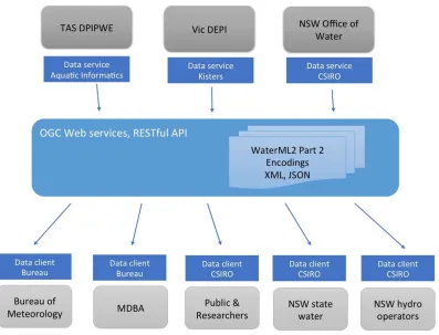
6.1 Scenario 1 – Inter agency exchange (Australia)
This Australian scenario involves data exchange between five organizations:
Data suppliers: Tasmanian Department of Primary Industries, Parks and Wildlife
(DPIPWE), NSW Office of Water
Data consumers: Bureau of Meteorology, Murray Darling Basin Authority
(MDBA), CSIRO, Victorian Department of Environment & Primary Industries (DEPI)
The Bureau receives hydrological data from water agencies within Australia, but there is no web-service access to allow ad-hoc or dynamic requests for these data. The IE
provided an exemplar of how this may occur for ratings and gaugings.
The major interoperability challenges in this scenario include:
• Representation of rating tables in a consistent form. Each agency describes
rating tables differently, without consistent semantics for the core domain concepts.
• Different vocabularies. There are no agreed on national or international
standards for codes and vocabularies within Australia for terms such as data quality, observed properties and so on. The Water Data Transfer Format (WDTF) used by the Bureau to ingest data from water agencies provides some precedent, and may be re-used for the purposes of the IE.
• No web-service access. There are currently no means for accessing rating and
gauging data over the web, outside of generated HTML or PDF reports.
Figure 1 shows the setup of the exchange in this scenario.
Figure 1 - Australian exchange scenario
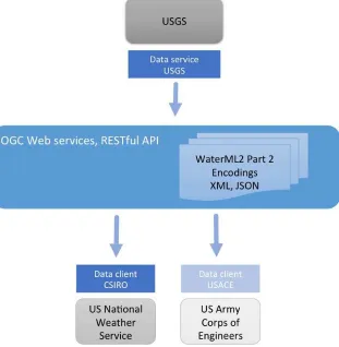
6.2 Scenario 2 – River Modeling and Flood forecasting (United States)
gaugings to run flood-forecasting models. The USACE also requires these data to
manage reservoirs and maintain navigable waterways nationwide. There is current rating table exchange occurring between the three agencies. There are plans to improve this exchange especially in light of the USGS’ adoption of new commercially developed data-processing software which does not support the existing rating-exchange format. The OGC WaterML2/0 IE was identified as a potential way to prototype new sharing arrangements. Figure 2 shows the exchange scenario.
Staff from the National Weather Service have conducted a preliminary review of the WaterML2 Part2 encodings and have just recently identified a project to begin work on a client, however, neither they nor the US Army Corps of Engineers implemented a client in time for this IE.
Figure 2 shows the setup of the exchange in this scenario.
Figure 2 - US exchange scenario
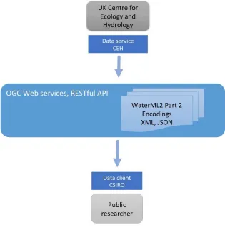
6.3 Scenario 3 – Public data publishing (United Kingdom)
clients. Increased data sharing between agencies and development of complex clients will benefit the adoption of standards-based web-services. A CSIRO web-client was used to show how a standards-based client can consume multiple WaterML2.0 data services.
• Interoperable client - Web client accessing different implementations of the
same service.
Providing consistent Open Data. The simple act of making data available (open) is a
good step towards improved data access. Further, providing data in a common, well-described format enhances a community’s ability to share tools and experiences. Figure 3 shows the setup of the UK exchange in this scenario.
Figure 3 - UK exchange scenario
6.4 Scenario 4 – Validation and Visualization
consistent use of the WaterML2.0 part 2 information model and provided a demonstration of interoperability across services.
Figure 4 shows how a cross-agency client provides access and visualization across the services used for this IE. This client relies on implementations being consistent in the implementation of the WaterML2.0 part 2 information model and web services. The details of the validation implementation are outlined below.
Figure 3 shows the setup for validation and visualisation using the cross service integration client.
Figure 4 - Cross-service visualisation
7.
Requirements
7.1 Ratings
ID Query Parameters Returns
R1 Get latest rating MP ID Single rating
R2 Get rating periods MP ID, rating group ID Collection of rating periods
R3 Get rating table X, Y, Z MP ID, rating IDs Collection of rating tables
R4 Has the latest rating changed since this date?
MP ID, Date Last change date
R5 Has the rating period changed since this date?
MP ID, Date, paramFrom/To
Last change date
R6 Have these ratings X, Y, Z changed since this date
MP ID, Date Collection of change dates to rating IDs
R7 List all the paramFrom/To combinations
MP ID Collection of paramFrom/To combinations (i.e. rating groups)
7.2 Gaugings
ID Query Parameters Returns
G1 Get the latest gauging MP ID Single gauging observation
G2 Get gauging X, Y, Z MP ID, gauging IDS Collection of gauging observations
G3 Get gaugings since this date MP ID, date Collection of gauging observations
G4 Get all From/To combinations MP ID Collection of paramFrom/To combinations
7.3 Cross-sections
ID Query Parameters Returns
CS2 Get cross-section after this date MP ID, date Collection of cross-sections
CS3 Get all cross-section identifers MP ID Collection of cross-sections
IDs/references
7.4 Range periods
ID Query Parameters Returns
RP1 Get all range periods MP ID Collection of range periods
8.
Service implementation options
This section describes the potential implementation options for encoding the
WaterML2.0 part 2 information model using web services. There were two possible OGC services to encode RGS data: the Sensor Observation Service (SOS) and the Web Feature Service (WFS). In addition we also considered a third non-OGC RESTful service option.
8.1 Services considered
8.1.1 Sensor Observation Service (SOS)
SOS is designed as an interoperable web-service for a range of observational data, from in-situ to mobile sensor platforms. It defines a simple core that provides basic metadata and access to observational data. SOS makes use of Observations & Measurements (OM) for data delivery encoding.
8.1.2 Web Feature Service (WFS)
The WFS is a flexible service for exposing feature-based views of data sets. Complex features, such as those resulting from WaterML2.0 part 2, can be exposed by mapping internal data stores (e.g. data in relational databases) to XML schema elements. It provides a rich query interface to access specific features based on properties and their values.
8.1.3 Representational State Transfer (REST) Service
RESTful services make use of standard HTTP calls – GET, POST, PUT, DELETE, OPTIONS etc – coupled with service-specific resources on which these actions may be performed. A summary of RESTful services is out of scope of this document; references are provided for further reading2.
8.2 Implementation design
There are a number of approaches to implementing WaterML2.0 part 2 with WFS and SOS. The inherent flexibility of WFS, and to a lesser degree, SOS, results in many possible configurations for deployment. The following section discusses how the WaterML2.0 part 2 information model may fit with the OGC services.
8.2.1 Ratings - Conversions, ConversionGroups and RangeValues in SOS
While conversions are built using individual observations, they are a derived product that only has a relationship to actual observations. Within WaterML2.0 part 2 they are
modeled as individual feature types, with relationships to OM_Observation (gaugings). There is no directly applicable connection to the primary function of SOS, which is essentially delivery of OM_Observation and/or SensorML encodings.
These objects have a more natural fit to the WFS, given its general support for delivering ‘feature’ data. It does however have trouble with temporal subsetting and may not be able to respond to ‘get latest’ type requests.
One can argue whether conversions are ‘spatial features’, but when operating within the abstract OGC architecture3, most objects of importance are modeled as features. The OGC general feature model is analogous to object-oriented modeling in programming languages: model everything as a type of object (class/feature-type) and give it properties (attributes) and objects (features/instances) can be related to one another.
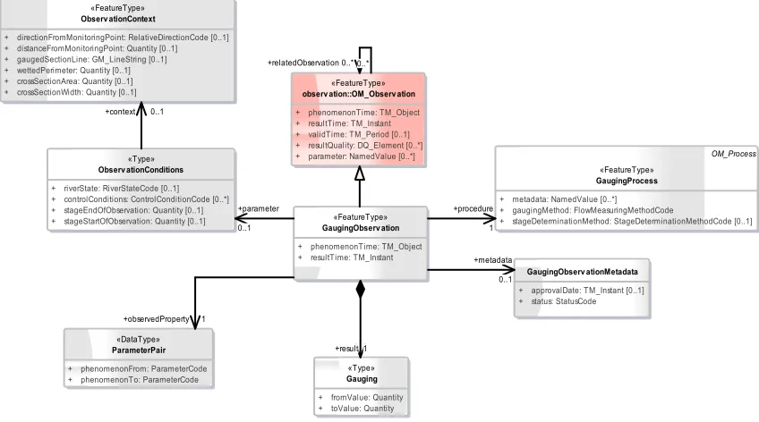
8.2.2 Gaugings in SOS
The GaugingObservation type defined in WaterML2.0 part 2 is a specialization of the OM_Observation type, as shown in Figure 5. The GaugingObservation type adds contextual metadata for the observation, such as observation conditions, the geometry of the observation line, and methods used; while also restricting the result to be a tuple that captures the independent variable (e.g. river level) and dependent variable (e.g. river flow).
Figure 5 - The gauging observation core types
The SOS service is designed to deliver and query OM_Observation data. Using a SOS to handle gaugings would therefore provide temporal filters on observation time, spatial filters for observation area, and filters for requesting conversions of specific phenomena. These queries cover the basic gauging requirements detailed in section 7, but further investigation is required to ensure the solution is adequate.
3
OGC Abstract Specification: Topic 5 - Features. http://portal.opengeospatial.org/files/?artifact_id=29536
«DataType» ParameterPair
+ phenomenonFrom: ParameterCode + phenomenonTo: ParameterCode
«FeatureType» Observ ationContext
+ directionFromMonitoringPoint: RelativeDirectionCode [0..1] + distanceFromMonitoringPoint: Quantity [0..1] + gaugedSectionLine: GM_LineString [0..1] + wettedPerimeter: Quantity [0..1] + crossSectionArea: Quantity [0..1] + crossSectionWidth: Quantity [0..1]
«Type» Observ ationConditions
+ riverState: RiverStateCode [0..1] + controlConditions: ControlConditionCode [0..*] + stageEndOfObservation: Quantity [0..1] + stageStartOfObservation: Quantity [0..1]
OM_Process «FeatureType»
GaugingProcess
+ metadata: NamedValue [0..*] + gaugingMethod: FlowMeasuringMethodCode
+ stageDeterminationMethod: StageDeterminationMethodCode [0..1]
GaugingObserv ationMetadata
+ approvalDate: TM_Instant [0..1] + status: StatusCode
«FeatureType» GaugingObserv ation
+ phenomenonTime: TM_Object + resultTime: TM_Instant
«Type» Gauging
+ fromValue: Quantity + toValue: Quantity
«FeatureType» observ ation::OM_Observ ation
+ phenomenonTime: TM_Object + resultTime: TM_Instant + validTime: TM_Period [0..1] + resultQuality: DQ_Element [0..*] + parameter: NamedValue [0..*]
There is one issue relating to vocabularies: the GaugingObservation type encapsulates two observed properties into the OM_Observation/observedProperty attribute: the independent and dependent variable (as shown in the ParameterPair type in Figure 5). This may require the service to resolve a composite vocabulary element (e.g. a term capturing ‘stage-discharge’) to match a query against an individual phenomenon, such as stage. IE participants may be required to provide this support in the RESTful web service. This discussion is outlined in detail on the OGC working group page4.
8.2.3 Gaugings in WFS
Being a feature type, Observations are supported within WFS but there are no ‘first class’ queries that match the key properties of the observation type (e.g. time, phenomenon). The queries would need to be submitted using the OGC’s Filter Encoding standard5 that allows generic filtering on feature properties. While these are powerful, they have a relative high barrier to entry, requiring XPath6 like statements. Annex B contains example statements for comparison.
8.2.4 Cross-sections in SOS/WFS
As shown in Figure 6, cross-sections are modeled as a specialized type of OM_GeometryObservation as they are observations of geometric structure (i.e.
observations that have a geometric type as their result). They therefore fit SOS given its ability to deliver multiple types of OM_Observation objects. As with gaugings, it would be possible to deliver cross-sections observations using a WFS, but the SOS provides the primary access functions useful for handling observational data and is thus recommended as the delivery mechanism for cross-sections.
4 http://external.opengis.org/twiki_public/HydrologyDWG/RGSHandlingVocabsInService 5
http://www.opengeospatial.org/standards/filter
Figure 6 - Cross section observations
8.3 Summary
WFS, in theory, could handle all parts of WaterML2.0 part 2, although depending on the way time-series are structured it has been shown that it can be tricky to query time-series in WFS. When handling multiple features through a WFS instance, all queries are
handled using a single GetFeature call. GetFeature parameters are used to control the queries for specific feature types. The OGC Filter Encoding standard is used to specify the semantics of the query statements. These are powerful capabilities but require a good understanding of filter encoding to form a valid expression. An example monitoring point query is explored in Annex B.
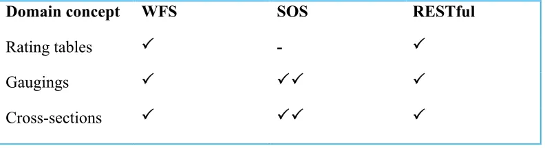
Table 1 summarises how the above WaterML2.0 part 2 types match the service
interfaces.
Table 1 - Handling of WaterML2.0 part 2 types with services
Domain concept WFS SOS RESTful
Rating tables -
Gaugings
Cross-sections
Could be delivered using this service
Provides specific calls/queries for this type of data
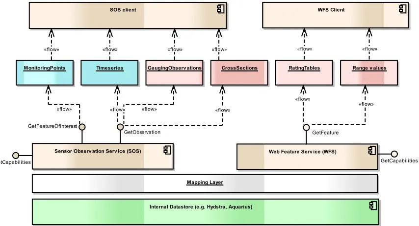
8.4 OGC service deployment
A potential deployment of both SOS and WFS is shown Figure 7. The key information objects are shown, with blue indicating WaterML2.0 part 1 and red showing part 2 objects. This approach makes use of SOS for Gaugings and Cross-sections and WFS for conversions and range values.
Figure 7 - implementation with OGC services (blue indicates WaterML2.0 part 1 types, red is part 2)
Recommendation: Use SOS to deliver GaugingObservations and CrossSections.
Recommendation: Use WFS to deliver RatingTables and RangeValues
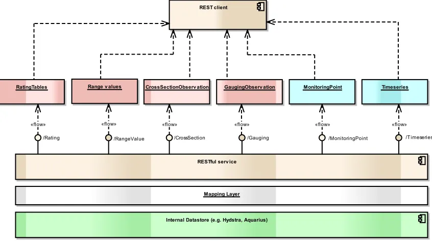
8.5 RESTful service implementation
As shown in Figure 8, the OGC web services approach can be contrasted with a RESTful service design. Using a RESTful approach, the WaterML2.0 part 2 information model defines the REST resource endpoints. Using a REST approach, the resulting service interface is more specific to the type of data that is being exposed. This has pros and cons: the API becomes more self-descriptive of the data, resulting in easier interpretation
Sensor Observ ation Serv ice (SOS) GetObservation GetFeatureOfInterest
GetCapabilities
Timeseries
Web Feature Serv ice (WFS) GetFeature
GetCapabilities
MonitoringPoints GaugingObserv ations CrossSections RatingTables
Internal Datastore (e.g. Hydstra, Aquarius) Mapping Layer
Range v alues
SOS client WFS Client
«flow» «flow»
«flow»
«flow» «flow» «flow»
«flow» «flow»
«flow» «flow»
of the service interface; but the service is more tightly bound to the information model and thus not reusable across information models. This key difference can be summarized as: A WFS implementation contains the domain-specific aspects in its response types and query definitions, whereas in a RESTful service puts them in the resource endpoints and supported query parameters.
Figure 8 - RESTful service design (blue indicates WaterML2.0 part 1 types, red is part 2)
8.6 Recommended service implementation
The SOS-WFS implementation required the IE participants to understand and implement two additional service specifications, adding a significant level of complexity to the IE operation. Implementation is easier if the developers are familiar with these OGC services. However, in the case of the IE most participants had not implemented either service. Additionally, most participants are taking part through an in-kind contribution and thus development time is quite limited. For these reasons, the IE proceeded with a RESTful implementation of the information model. For operational and longer-term service deployments, the use of OGC may be more desirable – this would depend on individual organization requirements and development capacity.
IE Implementation decision: Participants in the IE chose to primarily implement the
RESTful web service to perform the interoperability experiment.
9.
The IE information model
The information model used for the IE is a profile of the full WaterML2.0 part 2 model. A profile here refers to a model that:
Internal Datastore (e.g. Hydstra, Aquarius) RatingTables CrossSectionObserv ation GaugingObserv ation
Mapping Layer
MonitoringPoint
Range v alues Timeseries
RESTful serv ice
/Rating /RangeValue /CrossSection /Gauging /MonitoringPoint /Timeseries
REST client
• Adds properties required for use by the RESTful web service;
• Restricts the cardinality of properties.
This profile is thus an implementation-level model that captures requirements specific to implementation in the RESTful web service used in the IE.
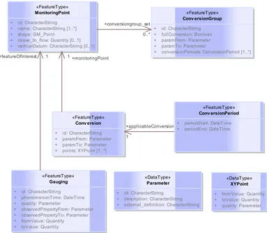
A simplified view of this model is shown in Figure 9. This view simplifies the model in a number of ways:
1. Base-type attributes (e.g. id, name etc.) are shown directly in the feature types to improve readability;
2. Represents objects that are encoded as by reference (i.e. through a URL) as directed associations;
3. Represents inline objects as direct attributes of the type.
4. Similar to 1, some types have been collapsed together to avoid additional sub properties (e.g. in the Gauging type, the from/to values are direct attributes rather than defined in a specific type).
Figure 9 - The WaterML2.0 part 2 profile used in the IE «FeatureType»
MonitoringPoint
+ id: CharacterString + name: CharacterString [1..*] + shape: GM_Point
+ cease_to_flow: Quantity [0..1] + verticalDatum: CharacterString [0..1]
«FeatureType» Conv ersionGroup
+ id: CharacterString + fullConversion: Boolean + paramFrom: Parameter + paramTo: Parameter
+ conversionPeriods: ConversionPeriod [1..*]
«DataType» Parameter
+ id: CharacterString + description: CharacterString + external_definition: CharacterString
«FeatureType» Conv ersionPeriod
+ periodStart: DateTime + periodEnd: DateTime «FeatureType»
Conv ersion
+ id: CharacterString + paramFrom: Parameter + paramTo: Parameter + points: XYPoint [1..*]
«DataType» XYPoint
+ fromValue: Quantity + toValue: Quantity + quality: Parameter «FeatureType»
Gauging
+ id: CharacterString
+ phenomenonTime: DateTime + quality: Parameter
+ observedPropertyFrom: Parameter + observedPropertyTo: Parameter + fromValue: Quantity
+ toValue: Quantity
The model in Figure 9 is as an ‘as built’ model. Some attributes/relationships have been renamed from the base WaterML2.0 part 2 model. The semantics have remained the same. This model represents the key required classes and types that provided the
functionality required for the IE. This model is a suitable candidate for a definition of the core conformance classes for the part 2 specification.
Managing complexity is an ongoing challenge for information modeling within the OGC/ISO framework. An example is comparing the above described, simplified and implementation focused model with that of a fully expressive model, which maintains full relationships to its re-used/sub-typed features and types. Both approaches are useful and required as they serve different purposes. However, there is no formalized way to express the relationship between the two using the current UML profile. However the concept of ‘Mixins’7 is similar and could allow model views to be simplified for specific needs. The ShapeChange8 tool has also developed model transformations to support flattening a model9 and profiling10 models. The details of these functions are relatively recent and were not used in this IE.
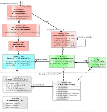
9.1 Gaugings implementation model
Figure 10 shows the full class hierarchy for the gaugings classes. The profile types have collapsed parts of the relevant types into the concrete implementation types used for the IE.
7http://en.wikipedia.org/wiki/Mixin & http://shapechange.net/targets/xsd/extensions/mixin/ 8 Processing application schemas for geographic information: http://shapechange.net/ 9
http://shapechange.net/transformations/flattener/
Figure 10 - Gaugings and Monitoring Point class hierarchy (red = ISO19156 (O&M), blue = part 1, green = part 2, white = IE profile types)
9.2 Conversions implementation model
Figure 11 shows the types used for representation of conversions (ratings, groups, points) and their relationship to the full WaterML2.0 part 2 model.
Gaugings implementation profile
«FeatureType»
IE RGS Profile::Gauging
+ id: CharacterString
+ phenomenonTime: CharacterString + quality: Parameter
+ observedPropertyFrom: Parameter + observedPropertyTo: Parameter + fromValue: Quantity + toValue: Quantity
«FeatureType»
IE RGS Profile::MonitoringPoint
+ id: CharacterString + name: CharacterString [1..*] + shape: GM_Point + cease_to_flow: Quantity [0..1] + verticalDatum: CharacterString [0..1]
«DataType»
IE RGS Profile::XYPoint
+ fromValue: Quantity + toValue: Quantity + quality: Parameter
«FeatureType»
Monitoring Point::MonitoringPoint
+ descriptionReference: GenericName [0..*] + localDatum: CD_VerticalDatum [0..*] + monitoringType: GenericName [0..*]
«Type»
Gaugings::Gauging
+ fromValue: Quantity + toValue: Quantity
«FeatureType»
Gaugings::GaugingObserv ation
+ phenomenonTime: TM_Object + resultTime: TM_Instant
«FeatureType»
observ ation::OM_Observ ation
+ phenomenonTime: TM_Object + resultTime: TM_Instant + validTime: TM_Period [0..1] + resultQuality: DQ_Element [0..*] + parameter: NamedValue [0..*]
«FeatureType»
+ positionalAccuracy: DQ_PositionalAccuracy [0..2]
GFI_Feature
«FeatureType»
samplingFeature:: SF_SamplingFeature
+ parameter: NamedValue [0..*] + lineage: LI_Lineage [0..1]
Figure 11 - Conversion type hierarchy (green - part 2, white - IE implementation)
9.3 Vocabularies
The main required controlled vocabulary for the IE was for the definition of the observed properties/phenomenon (paramFrom/To). The IE participants agreed to use codes
developed for the Australian Water Data Transfer Format (WDTF), and extend where required. These codes are included in Annex B.
10.
Scenario Implementations
This section describes the implementation and deployments that occurred within each of the scenarios of the IE.
10.1 Australian scenario – cross agency exchange
The Australian scenario involved the provision of data though three Australian agencies and the use of the data in the CSIRO validation and visualization clients as well as the Bureau of Meteorology integration client. The data provision agencies, the data types provided and the RGS service implementers are listed in Table 2.
IE Conversion types
«FeatureType»
IE RGS Profile:: Conv ersion
+ id: CharacterString + paramFrom: Parameter + paramTo: Parameter
«FeatureType»
Conv ersions::Conv ersion
+ phenomenonFrom: ParameterCode + phenomenonTo: ParameterCodeA
«FeatureType»
Conv ersions::RatingTable
+ defaultQuality: DataQualityCode
«FeatureType»
Conv ersions::Conv ersionPeriod
+ periodEnd: TM_Instant [0..1] + periodStart: TM_Instant
+ phasedPeriod: TM_PeriodDuration [0..1] = false
«FeatureType»
Conv ersions::Conv ersionGroup
+ domainFeatureClass: DomainFeatureClassCode [0..1] + fullConversion: Boolean [0..1]
+ phenomenonFromDatum: CD_VerticalDatum [0..1]
«FeatureType»
IE RGS Profile::Conv ersionGroup
+ id: CharacterString + fullConversion: Boolean + paramFrom: Parameter + paramTo: Parameter
+ conversionPeriods: ConversionPeriod [1..*]
«FeatureType»
IE RGS Profile:: Conv ersionPeriod
+ periodStart: DateTime + periodEnd: DateTime + points: XYPoint [1..*]
«DataType»
IE RGS Profile::XYPoint
+ fromValue: Quantity + toValue: Quantity + quality: Parameter
«Type»
Conv ersions:: TableTuple
+ fromValue: Quantity + toValue: Quantity
Table 2 - Summary of Data sources, scope and service providers
New South Wales Office of Water (NOW)
CSIRO
Victorian Department of Environment and Primary Industries
Kisters, Hydstra
Tasmanian Department of Primary Industries, Parks, Water and Environment
Aquatic Informatics, Aquarious
BOM, Australian Water Resource Information System
Kisters, Wiski
The BOM integration client requested ratings, gaugings and sections from the web services and processed the information into the Hydstra Time Series Data Management System. Additionally, a WaterML2.0 part 1 compliant Sensor Observation Service was used to retrieve time-series for comparison of gaugings against relevant hydrographs. The Hydstra system was used to inspect and quality assure ratings, using gaugings and
sections. The system also produced derived flow values using ratings and time series. Planning for the IE indicated that other exchange scenarios are likely and include:
• The Murray Darling Basin Authority (MDBA) retrieving ratings from NOW.
• NSW Hydro power operators retrieving data from NOW
• Other inter-agency transfers.
10.2 US Scenario
The US scenario involved adding a new WaterML2 Part 2 compliant interface to the existing USGS ratings depot, which aggregates all active ratings from 45 Water Science Center databases nationwide and makes them available via a public-facing web service. The existing USGS production ratings service supports approximately 35,000 public requests per day primarily by the National Weather Service and US Army Corps of Engineers but also by various utilities, commercial interests, and academic institutions. The development of WaterML2.0 part 2 is important, as the USGS has begun converting its timeseries data processing from a legacy system developed in-house to a new
commercial product, which does not support the old/existing rating-file format.
Deployment of the new data-processing system is slated for late summer 2015 at which time the WaterML2 part 2 standard will be the only format offered to the public from the USGS ratings depot.
The US scenario made use of the CSIRO validation and visualization clients.
10.3 UK Scenario
The UK’s Centre for Ecology and Hydrology (CEH) hosts the UK National River Flow Archive, which includes a national dataset of peak flow data and associated ratings. This data is available via web-services but only to facilitate display. Future users would be expected to access the web-services via clients for which a standard would be beneficial. The scenario involved testing the part 2 model as a mechanism for publishing data online,
CSIRO RGS API KISTERS API Aquatic
Informatics API
«Database»
NSW Office of Water
«Database»
Vic DEPI
«Database»
Tas DPIPWE Bureau of Meteorology retriev al
with the goal of enabling users to explore data and understand the implications of ratings on flow data. An API was built on the existing service infrastructure (already contains some JSON APIs) to expose the WaterML2.0 part 2 API.
Example html page: http://www.ceh.ac.uk/data/nrfa/data/peakflow.html?27080 Example web-service: http://www.ceh.ac.uk/nrfa/json/hiflows-ratings?station=27080 The CEH scenario made use of the CSIRO validation and visualization clients.
Whilst the range-values aspect of the part 2 model was not implemented, it was assessed for applicability to the range of rating metadata (including equations and extrapolation information) that is often used for qualitative assessment of ratings.
10.4 Validation and Visualisation
The IE participants developed a validation script to allow developers to provide early and quick feedback on implementations. The validator was initially a standalone script11, but was then provided as a web page. This allowed the validator to be run quickly without requiring installation – this was a requirement for developers operating in constrained environments. The service was made available at http://waterml2.csiro.au/validator and uses a base URL and a test monitoring point ID that is used for subsequent calls. The components and operation of the validator is shown in Figure 12 and Figure 13.
Figure 12 - Validation components
11 https://github.com/peterataylor/WaterML2-part2-api-tester
CSIRO RGS API USGS RGS API KISTERS API Aquatic Informatics API
«Database»
NSW Office of Water
«Database»
Validation w eb site
Figure 13 - Validation workflow
10.4.1 Visualisation client
A web-based visualization client was developed that made use of the core operations and information objects. As the services were validated, they were then made available for visualization in the web-client. The client is available at http://waterml2.csiro.au/rgs-api/v1/viz/. This client allows visualization of ratings and gaugings across a selection of sites for each service implemented within the IE. The basic interaction between client and services is shown in the sequence diagram in Figure 14.
Developer
Validator web page
Validator Script RGS API
Gauging results() TestMonitoringPoint (URL, MP ID)
GET /monitoring-point/(MP ID)
ValidateJSON() :MP (JSON)
ConversionGroups (JSON) GET /gauging?monitoring-point=MP_ID()
ConversionGroup results()
ReportResults()
MP results()
ValidateJSON() Validate(API URL, Monitoring Point ID)
Gaugings (JSON)
Figure 14 - Visualization client service interactions
The service catalog shown in Figure 14 is implemented as a lightweight internal catalog using a set of configuration parameters. This catalog allows quick addition of new services and monitoring points for testing. In a more formalized architecture the service catalog would likely be a web service implementation, such as the OGC Catalog
Service12, or something offering similar functionality. This would allow dynamic
additions and general management of the service instances. A screen shot of an example
12 http://www.opengeospatial.org/standards/cat
User
Web Visualisation Client Service Catalog External WaterML2.0
Service
GET /monitoring-point(MP_ID): MonitoringPoint GetServiceDetails()
SelectPeriod()
Gaugings () Select MP()
SelectConversionGroup()
GET /gaugings(MP_ID): Gauging
GET /conversion-group(MP_ID): ConversionGroup UpdateMonitoringPointDetails()
Conversions() SelectSourceService()
MontoringPoint()
GET /conversion(ID): Conversion
ConversionGroupsWithPeriods ()
DisplayConversionPeriods()
PlotGaugings() Show available MPs()
ShowConversionGroups()
PlotConversionGraph()
site from the Victorian Department of Environment and Primary Industries (via KISTERS service implementation) is shown in Figure 15.
Figure 15 - IE visualization client
11.
JSON encoding
All of the IE participants expressed an interest in using JSON encodings for the operation of the IE. Given the limited time availability of participants and the relative complexity of the use of XML in OGC standards (as described above) the group decided to proceed with a JSON-based encoding of the part 2 model.
11.1 Standard JSON response headers
The most formalized definition of common JSON response structures appears to be OData13, however OData implementation does not yet appear to be widespread. Other
less formalized (and simpler) options also exist14, along with others that are generally rolled into a RESTful service framework (e.g. Django, Ruby on Rails etc.).
Standardisation of the JSON implementation was not an objective for the IE, and thus the implementation proceeded with the following guidelines:
• Use appropriate HTTP response codes for error conditions;
• Use a small header set, consisting of:
o “count” – number of records returned
o “next” – link to next set of results
o “previous” – link to previous set of results
o “results” – array of returned objects (as defined by the information model)
11.2 JSON Schema
JSON schema files were generated from the flattened UML (described in section 9) using the ShapeChange tool. The generated schema are available online:
• http://waterml2.csiro.au/part2/json/rgs-ie/Gauging.json
• http://waterml2.csiro.au/part2/json/rgs-ie/Conversion.json
• http://waterml2.csiro.au/part2/json/rgs-ie/ConversionPeriod.json
• http://waterml2.csiro.au/part2/json/rgs-ie/MonitoringPoint.json
• http://waterml2.csiro.au/part2/json/rgs-ie/Parameter.json
• http://waterml2.csiro.au/part2/json/rgs-ie/XYPoint.json
JSON mappings for the common GML types are partially available using ShapeChange, however some need further developing and/or publication in public locations. E.g. http://schemas.opengis.net/gsr/1.0/point.json
The JSON schema was not used for the initial validation due to time constraints. The first validator used a simple check of required elements to allow quick feedback to service developers.
14http://jsonapi.org/format/
http://labs.omniti.com/labs/jsend
12.
Challenges
12.1 Mapping to internal data structures
The part 2 information model is a generalization of a number of hydrological concepts. Most hydrological data management software implements a more detailed and expressive system for conversion of parameters. The aim of the WaterML2.0 model is to allow different systems to communicate ratings, gaugings and cross-sections with sufficient detail to allow a basic conversion to be run, or general analysis of the rating relationship (e.g. how many gaugings were used in its construction, how the gaugings deviate from existing rating(s) etc.). To fully express complex, multi-step parameter conversions, the information model would need to support expression of algorithms and process chains. This was deemed out of scope for the current information model, and given the subtleties and diversity of conversions is a very large task for exchange between different
information systems.
12.1.1 Identifiers
Most implementations in the IE ran into the problem of mapping objects from
WaterML2.0 for the case in which there is not an exact mapping for the concept in the internal system. For example, the concept of a rating group might not have an exact mapping. This required implementations to create a view that captures the concept and provides an identifier for that concept. However, this identifier would not relate to directly to an object, e.g. it may be compound identifier that is composed of multiple objects. This is generally OK for read only systems, but when a system is required to import and successfully parse an object, it can be difficult to unpack/relate the required objects. This is always a challenge when supporting a web service that is not a direct reflection of the internal information model.
In some cases, components of the compound identifier were potentially subject to change in the underlying system, e.g. they used application or observation dates. In the instance of where the identifier may change, this limits the ability of exchanged data to be positively reconciled with the source data system.
The objectives of WaterML2 part 2 are consistent with this limitation. There are no RGS requirements that require or imply the reconciliation of RGS data back to the source system.
The requirements of the RGS project are an expression of common domain concepts, a harmonization of the participant’s knowledge, and data system capabilities. The definition of common domain concepts inevitably involves a loss of content fidelity between the interoperable model and the source data systems. This loss of fidelity in data content means that the interoperable WaterML2 Part2 RGS format is not suitable for distributed maintenance of source system records.
12.2 Handling large service responses
The general RESTful behavior for collections is that a GET operation on a base resource (e.g. /monitoring-point) should return all resources available. This can result in very large responses. A paging mechanism was used in the IE to limit responses to a default size, with next/prev references provided as part of the header response. The paging pattern is common, and when parameterized (e.g. allowing client-specified page sizes within a lower/upper bound) can suit most implementation requirements.
These collections often need to be filtered using a query against desired attribute values. The exact entry point into these resources and queries is dependent on the requirements from calling clients. For example, the monitoring-point resource provides access to all monitoring points. It is generally rare for a client to request a full listing of monitoring points, more often requesting a spatial (e.g. bounding box) or other type (e.g. all river gauges) of subset. This IE was not focused on the issue of discovery, as these queries are usually available outside of data-specific services. For this reason the IE participants picked a subset of monitoring points to expose in the web-client and test in retrieval tools.
12.3 Separation of information model and web service
Separating issues associated with the specification of the API and those of the
information model design can be difficult. Relationships between feature types in the information model would suggest a link/reference between two resources in the REST resources; however, there is not always a direct mapping of these.
As discussed above, the API implements a profile of the information model with certain restrictions. A key point here is the use of inlineOrByReference for related feature types. For example, the ConversionGroup feature type contains a one-to-many relationship to ConversionPeriods. In implementation restricting this association to always be an inline
only relationship is useful, allowing the conversion periods to be expressed within the conversion group, thus minimizing the number of requests to retrieve all the conversion periods (some conversion groups contain many periods).
All the types used within the IE made design decisions of inline or reference by iterating the development, and crucially, writing clients that used the API to determine the desired behavior. Early implementations contained too many links, resulting in clients having to make many calls to the API for basic behavior.
12.3.1 Optimizing API return collections
When returning collections of multiple feature types it is often desirable to remove duplicate properties that are constant across all the features. This is generally the case when a property has been specifically queried through the API. For example, when requesting a collection of gauging observations for a specific monitoring point, parameter from and parameter to, the resulting collection will only ever contain observations with the same properties. Moving these properties to the top-level collection to avoid repeating for every encoded object is desirable.
This pattern has been addressed in the SWE Service Model standard in the
This outlines a ‘property inheritance mechanism’ whereby properties inherit their values from a parent or specific type through three rules:
1. No inheritance – the property is not inherited at all.
2. Replace – the sub-type values overrides any values specified by the parent type
3. Add – the sub-type values are added to the values specified by the base type. Only applies to list types.
Using this pattern defining a generic ObservationCollection type that supports defaulting of the key properties of the OM_Observation type is possible. An example model for this generic collection is shown in Figure 16.
Figure 16 - Observation collection type with property inheritance
There is an issue with the cardinality of the OM_Observation’s properties (e.g. the
featureOfInterest property is required), so implementation using the current XML schema would not be compliant with the current O&M XML Schema. This is a pattern worth considering for handling default/override values of features in collections to remove redundancy.
An example XML encoding is shown below. This example shows an example response that has a fixed feature of interest, observed property and procedure.
<omcol:ObservationCollection gml:id="ID000">
<gml:description>An example Observation Collection using property inheritence.</gml:description>
<omcol:procedure xlink:href="http://www.opengis.net/def/waterml/2.0/processType/Sensor"
«FeatureType»
Observ ationCollection
+ featureOfInterest: GFI_Feature [0..1] + observedProperty: GF_PropertyType [0..1] + resultQuality: DQ_Element [0..1] + parameter: NamedValue [0..*] + metadata: MD_Metadata [0..1] + procedure: OM_Process [0..1]
«FeatureType»
observ ation::OM_Observ ation
+ phenomenonTime: TM_Object + resultTime: TM_Instant + validTime: TM_Period [0..1] + resultQuality: DQ_Element [0..*] + parameter: NamedValue [0..*]
0..* +relatedObservation 0..*
xlink:title="Flow meter"/>
<omcol:observedProperty xlink:href=”http://waterml2.csiro.au/rgs‐
api/v1/def/observedProperty/pairs/stage‐discharge” xlink:title="Stage to discharge"/>
<omcol:featureOfInterest xlink:href="http://waterml2.csiro.au/rgs‐api/v1/monitoring‐
point/419009/" xlink:title="Peel River At Tamworth"/>
<omcol:member>
<om:OM_Observation gml:id="observation1">
<om:phenomenonTime>
<gml:TimeInstant gml:id="ti‐1">
<gml:timePosition>2011‐04‐14T00:00:00</gml:timePosition> </gml:TimeInstant>
</om:phenomenonTime> <om:resultTime>
<gml:TimeInstant gml:id="ti‐2">
<gml:timePosition>2011‐04‐15T00:00:00</gml:timePosition> </gml:TimeInstant>
</om:resultTime> <om:result>
<rgs‐ie:Gauging gml:id="gauging‐1"> <rgs‐ie:fromValue>
<swe:Quantity> <swe:uom code="m"/> <swe:value>1.1</swe:value> </swe:Quantity>
</rgs‐ie:fromValue> <rgs‐ie:toValue> <swe:Quantity>
<swe:uom code="cumecs"/> <swe:value>132</swe:value> </swe:Quantity>
Using this same approach with the JSON encoding gives:
{
"count": 325,
"next": "http://waterml2.csiro.au/rgs‐api/v1/gauging/?monitoring‐point=419009&page=2", "previous": null,
"featureOfInterest": "http://waterml2.csiro.au/rgs‐api/v1/monitoring‐point/419009/", "observedPropertyFrom": {
"id": "100", "description": "", "external_definition": "" },
"observedPropertyTo": { "id": "141", "description": "",
"external_definition": "http://neiivocab.bom.gov.au/std/water/xml/wio0.2/property/wdtf‐ parameters/WaterCourseDischarge_m3s"
},
"results": [ {
"id": 18953,
"phenomenonTime": "2011‐04‐14T00:00:00", "quality": 12,
"fromValue": "‐0.31600", "toValue": "110.02000" },
{
"id": 18868,
"phenomenonTime": "2011‐02‐15T00:00:00", "quality": 6,
"toValue": "138.42000"
This greatly reduces the redundancy in the responses, particularly as the response size increases. An implementation of this approach is being investigated in the next version of the API developed in the IE.
13.
Results
The primary goal of the IE was to test the draft WaterML2.0 part 2 information model against the exchange requirements defined by the RGS working group and to satisfy the exchange goals in each scenario. A table of the requirements defined by the group and the corresponding result from the IE is shown in Table 3.
Out of the 20 requirements statements, 13 were tested within this IE. Of the 7
requirements not tested, the functionality was available in the information model, but the features were not used in the implementations. This was generally because the data to test the feature was not available in the selected databases/information systems. For example, linking of the gaugings included and excluded in development of rating tables is
commonly identified as very useful piece of metadata, however these relationships were not explicitly available in the test systems. The decision was to keep these relationships in the model, as they were identified as highly valuable and may be encoded once supported in the underlying software.
Table 3 - requirements tested in the IE
ID Requirement Supported in
model?
Generalised conversion relationships are implemented rather than Stage/Flow only relationships. This enables relationships between user specified parameters to be defined.
Y Y
Yes. Existing structures are flexible for different parameter conversions.
2
The WML2 RGS implementation contains data used to complete the calculation of derived information. The definition of the process that would be employed to complete the transfer function / transformation is not currently in scope, my may be in scope at a later revision
Y Y Yes, current implementation reflects this.
3 Communicating the gaugings used in the creation of a rating is in scope. The
gaugings if interest are:
• Gaugings used that were taken in the period of application of the rating.
• Gaugings not used that were taken in the period of
application period of the rating. • Gaugings used that we taken
outside the application period of the rating. - e.g. high flow rating.
do not. This is because the underlying information systems currently do not track this information.
4
The inclusion of user specified user information that varies across the Y scale of a conversion is in scope. This would be used to give further information for the conversion. e.g.
Control/Chanel/OverBankFlow Assessment of other sensor application range
Y Y – partially.
A test implementation of range values has been completed in the CSIRO API. This resulted in some changes to the information model. Further implementations are being investigated.
5
Ratings should always have a point table supplied that is expanded at a sufficient Y scale resolution to enable linear interpolation between the supplied points. The creator of the data file will choose the export resolution such that linear interpolation is appropriate.
Y Y
Yes. This has been tested and seems to be a reasonable solution. Do we need a metadata element indicating the resolution that they have been expanded at?
6
Ratings may have the equation that is the source system definition of the rating. This may be supplied using rgs-4.
Y N
Yes, supported in the information model. No implementation examples exist, yet.
7
A point rating table may have additional information that enables the source system to describe how it stored the table.
Y N
Yes, supported in the information model. No implementation examples exist, yet.
8
Reverse conversions are not supported implicitly by either point or equations conversions. Reverse conversions can be defined explicitly.
Y Y
Supported by explicitly defining reverse tables (e.g. a flow to stage table).
9 Ratings are keyed to a Site / Point /
ParameterFrom / ParameterTo. Y Y
Yes. We changed this approach for a while but now key on
MP/paramFrom/To.
10
When defining stage as a parameter for a conversion, the stage datum must be supplied.
Y N
Yes supported by information model. Not tested directly by the IE.
11 Scope decision: The ratings being communicated are the 'Active ratings'. The ratings that would be applied to
determine ParameterTo value. It will have been shift corrected and will be the active rating at the time. Return should indicate the date and time for which the data applied
OGC specification, as it’s not really a service/encoding issue.
12 The use of conversion transitions /
phased change is in scope Y N
Supported by information model, but not tested in the IE.
13 The use of start dates for a conversions
period is agreed. Y Y
Yes, conversion period start dates were the primary rating period approach.
14
The use of end dates for a conversions period is agreed. The end dates is purely used for describing a gap. Rating gap periods can be implemented by end dates a or a null rating.
Y Y Yes implemented in the IE, but no specific test for this.
15
Rating point quality codes will be implemented at the point level. A rating quality can be defaulted with overrides for each point. Rating quality can be applied to equations. Rating quality can be communicated via an input range.
Y Y
Yes point quality for tables is supported in information model and implemented in the IE. A range values approach has not yet been tested.
16
Conversions can specify Y scale range validated range (within rating), extrapolated range, beyond extrapolation.
Y Y, but limited Supported in information model, not tested in IE.
17
There is a need for defining an input range purpose. An input range purpose should be a controlled vocabulary, the semantic meaning of each input range purpose should be defined against the vocabulary. Input range contents may vary over time, so should be referenced by periods of applicability.
Y Y, but limited Partially duplicating range values requirement.
18
The format should enable the inclusion of metadata to enable the communication ratings approval and review process
Y N
Supported in the encoding, but this information was not conveyed through the exchanges.
19
Specific methods for the communication of uncertainty information are not currently agreed across the domain. This is an area of current domain
development. The standard should be sufficiently extensible to enable incorporation when a direction is available.
Y Y
20 The conversion application period list may refer to a conversion table more