! " #
$ %
! " #
$%
& ' ! " # $
((& ( )& ! * + (
+ ' )& , '' "
' '' ' - ' , ,
, ' ' '' ((& )&
' ' ' ' ,
, ((& , # )./ & * 0 1 2 ,
)& # ' ,
% ' '' '
, 0 3/ 4 56 1
!"
+ #
'
#
'' ' 2
' ' #
' '
758 " ' #
' ' ' 768 "
' )&
, , 9 # #
758 " # ' '
#
, ' ,
7) 38
: , ''
' #
, " , '
'' '
'
#
7. ;8 7< =8 #
7> 5/8 , ' 755 568
# 75) 538 75.
5;8 " 5 2 '
5 !2 ' # 0 1 0 1
# 0 1
? '' '
2'
, - ,
'
, ,
' '
((& '
'' '
?
, %
9
0" @: 1
0 - '' , "*1 ,
-
!2 ' , 6
International Archives of the Photogrammetry, Remote Sensing and Spatial Information Sciences, Volume XXXIX-B5, 2012 XXII ISPRS Congress, 25 August – 01 September 2012, Melbourne, Australia
6 !2 ' ((&
' ' ((&
' '
, ((& 0& *1
' , '
, 2
,
#"
,
, ((& 0& *1
' , ' " , ((&
, , ( '
) =/
" ' ?
%
, ,
# # & *
, ,
" ) ,
)
, ' #
" ' ' ,
" '
, '
2 ' ,
'
, ,
' * ' , ,
,
# ,
' %
5
+
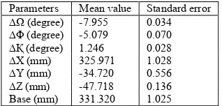
AB 0 1 #< >.. / /)3 AC 0 1 #. /<> / /</
AD 0 1 5 63; / /6=
AE 0 1 )6. ><5 5 /6= AF 0 1 #)3 <6/ / ..; AG 0 1 #3< <5= / 5);
H 0 1 ))5 )6/ 5 /6.
5 ' , ,
" '
' '
I - 2
4 '
' '
((& I ,
,
"
' 2'
"
2
, , '
'
, , ''
! , 3
3
" ' , "
# ' '
,
'
, ,
# , ' &
' , #
6
International Archives of the Photogrammetry, Remote Sensing and Spatial Information Sciences, Volume XXXIX-B5, 2012 XXII ISPRS Congress, 25 August – 01 September 2012, Melbourne, Australia
+
& ,
#
AB 0 1 #< ;3;. / )/>)
AC 0 1 #3 3<)3 / ;/;
AD 0 1 5 .;>6 / )66>
H 0 1 ))6 ;3=/ 5 )6<6
6 * # , ,
, #
6 ,
# ,
# #
' -
( - ' ,
'
4 '
, )
H #J 0 1 '
KE0 1 KF0 1 KG0 1 0 1
))6 ) 3.=3 3 /)>5 55 //)) 56 66/=
) '
4 '
! 0)1
' , # ))6 , '
"
,
6/ 6= , " , '
56 . ,
.
" ,
, '
, :
' ,
, ,
, % ? J ,
5 ,
, , % ,
4
'
4 '
, 3
H #J 0 1 '
KE0 1 KF0 1 KG0 1 0 1
))6 56 3;/< < >3// ). <56/ )= ;3<>
3 '
4 '
! 031
' , # ))6 , '
" ' ' ,
# , , '
2 0 2 G1 ' ,
$"
:
# , "
, '
- ' ' '
((&
' ' ,
((& 0& *1
' , '
, 2
' ,
((&
, ,
((& %
4 ,
' '
' '
L , ''
- -
% ' H
'' ' '' '
'
- 0
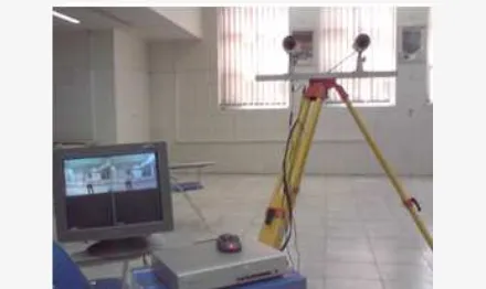
6// 1 2 -
4 0 6. 1 '
'' -
"
, # ,
4
' 2
International Archives of the Photogrammetry, Remote Sensing and Spatial Information Sciences, Volume XXXIX-B5, 2012 XXII ISPRS Congress, 25 August – 01 September 2012, Melbourne, Australia
" , '' ((& ,
, - ' 2 0,
1 '' '
'
' '
''
758 ( & G L 6//5 * J
+ + +
" '' >3#>>
768 ? & ? F & ( % & 6//3
)& * * "
J + " "!!! !
" ( " ''
5//<#5/56
7)8 L L ( L F + 5>>= +
" , & ' M '
? ' " + '' 5>;#
6/=
738 N % L F % F ,
6/// ( +
! + " *
( ' ? ' "!!! "
( + * '' 33#;)
7.8 J L F L ? J ( L J
6//= & ' * ?"
( ' ! ''
)=O3=
7;8 N M :% 6//; +
)& * * ( ,
' !' ' ( "!!! ( '
( ( ' + *
'' )<5O)<=
7<8 J * F J & M H 6//= , ? #
H + " +* ( (
7=8 + N 6//< (
+ + , + ( + &
& ,
" 0! L1 G
7>8 L L P G P N 6//= )&
*
+ + ' " (
+ * ' "
(
75/8 L G ( ! J 5/>; : ,
J +"! :' " " '' 6./O6.;
7558 '9@@,,, / #);/ 7568 '9@@,,,
75)8 N " % N " F L
6//< )& * * #
H : #& ?+ @&*
( ' * * '' ;6.#
;);
7538 ? ? M 5>>) & #
J ( + * '' >6)O
>)<
75.8 ( '' H * * N M ?
+ 6//= )& ( *
"!!! * M % ' ( '
75;8 , F , ", L % L
:% 5>>= ? L #*
+ " :
L 2 + 53 "
( + * '' 3=.#3=>
International Archives of the Photogrammetry, Remote Sensing and Spatial Information Sciences, Volume XXXIX-B5, 2012 XXII ISPRS Congress, 25 August – 01 September 2012, Melbourne, Australia