The International Archives of the Photogrammetry, Remote Sensing and Spatial Information Sciences, Volume XL-1, 2014 ISPRS Technical Commission I Symposium, 17 – 20 November 2014, Denver, Colorado, USA
This contribution has been peer-reviewed.
However, most all commercially operated RPAS belong to the lowest weight classes, as this gives the easiest access to obtain a flight permit which still bears several operational constraints. Figure 1 shows as an example of an light weight RPAS the G180 manufactured by GerMAP, Germany, with less than 5 kg MTOW, 180 cm wingspan, and a VLOS range of approximately 1.3 km. One can replace its wings to a wingspan of 220 cm, a G220, and even extend its VLOS range somewhat. G180 resp. G220 can cover an area of e.g. 1.5 km2 flown in approx. 30 min when operating in 100 m above ground level (AGL) with 80 % along-track and 70 % across-track overlaps, equipped with one nadir looking 16.2 Mpix RicohGR camera having 4828 pixels across-track and a focal length of 18.3 mm delivering from this AGL close to 3 cm ground sampling distance (GSD).
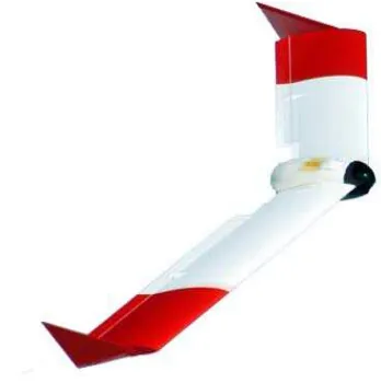
Figure 2 displays an even lighter RPAS, the SmartOneC with 1.2 kg MTOW manufactured by SmartPlanes, Sweden, detach-able wing halves and 120 cm wingspan. It thus fits into the 1a class of flight permit for Scandinavia.
Figure 2. SmartOneC (S1C), 1.2 kg MTOW, 800m VLOS range
3. RPAS – EXPERIENCES AND CONSIDERATIONS
We fly with fun but not for fun, since the goal is always to generate aerial images for photogrammetric data processing. What we are after, are deliverables such as orthomosaics, digital surface or terrain models, and derivatives thereof such as volumes, profiles, or contours. Available professional photo-grammetric software such as Trimble-Inpho's MATCH suite of software is capable of processing RPAS-imagery. It might be required to know some details of the software applied in order to correctly set proper parameters.
At time of starting in 2006 with RPAS-Mapping or UAV-Mapping, as one may call it, there was no RTK equipment on a component level available for integration into small, light weight UAVs. Thus, many commercial RPAS operate based on single phase GPS, i.e. without RTK, still. Yet, one can produce deliverables in very good quality, see Figure 3. Depending on the geometry of the block or blocks to be flown, one distributes a number of ground control points (GCP) and measures them via differential GPS. Also, with RTK one will want to perform some sort of quality check and control, and this requires a few GCPs anyway. Measuring a few more GCPs which due to the small size of area covered by RPAS-Mapping, as compared to manned aircraft aerial survey, often is correlated to short
dis-tances between GCPs and thus easily possible to be accomplished. RTK certainly will bring even more performance to RPAS-Mapping, but as of now it seems to increase the entry price level into this technology above the threshold for many users.
From quite many and different projects we obtained a stable confirmation in achieving a planimetric accuracy of approx. 0.5 GSD and an accuracy in height of approx. 0.8 to 1.5 GSD if image data gets properly processed. This is valid for GSDs as small as 4 cm or larger. GSDs of smaller size than 4 cm have the planimetric accuracy sort of asymptotically approaching 1 GSD and height accuracy is drifting towards 1.5 GSD. For data processing we apply the aforementioned MATCH suite of
Table 1. Typical projects and their main parameters Facing the type of cameras used in RPAS vs. the many orders of magnitudes more expensive and highly sophisticated large format digital optical sensors such as ADS, DMC, or UltraCam these simple cameras deliver surprisingly good imagery, very much usable in photogrammetric measurement techniques.
Figure 3. Orthomosaic, 3 cm GSD, RicohGR, flown with S1C A little survey on change of focal length of a Canon S100 camera over time is shown in Figure 4. This camera gets next to other cameras used e.g. in S1C, G180, or GerMAP's G212 but The International Archives of the Photogrammetry, Remote Sensing and Spatial Information Sciences, Volume XL-1, 2014
ISPRS Technical Commission I Symposium, 17 – 20 November 2014, Denver, Colorado, USA
This contribution has been peer-reviewed.
has no fixed focus and thus has to be firmware-driven put into infinite auto-focus lock position each time it gets applied in a RPAS-Mapping mission.
From February to July 2013 we selected 18 blocks flown with the identical Canon S100. Each time the Canon S100 gets used, its firmware moves the lens to its – as the firmware thinks – identical numerical position representing infinity. The actual focal length, however, varied between 5.3696 mm, see number 4 in Fig. 4, and 5.3881 mm, see number 5 in Fig. 4. For such a small and simple camera, this variation could be considered as pretty small. Yet, one needs to model it in the photogrammetric data processing path.
Figure 4. Focal length time series of the same Canon S100 One way to cope with this variation is to get mentally away from a static metric camera model towards a dynamic non-metric camera model with varying focal lengths and distortions as per switch-on-off cycle, thus having the need to apply self-calibration during aerial triangulation for on-line determination of the frequently changing interior orientation parameters. How-ever, this requires some measurable GCPs.
Table 2 compares the two mentioned cameras Canon S100 and RicohGR, see Figure 5. For flight planning the two values focal length vs. pixel pitch and pixels across track are most important ones. Here, the younger RicohGR is an advantage as it delivers from approximately 25% higher AGL the same GSD, which in turn reduces the number of photo strips to fly, i.e. RicohGR delivers an increase in efficiency. Moreover, the larger pixel-area for photon collection in RicohGR improves image quality to some extent.
Item Canon S100 RicohGR
Type of focal length Variable Fixed
Focal length (FL) [mm] 5.3696 to 5.3881 18.3
Pixel pitch (PP) [micron] 1.82 4.8
Ratio FL / PP 2956 3812
Table 2. Canon S100 vs. RicohGR
Figure 2 depicts the Canon S100 and RicohGR cameras used in RPAS operations. Of course, other brands get applied as well and might have e.g. larger Mpixel values, but also higher weights to carry in the UAV. The across track coverage and the ratio FL / PP are the parameters which count when optimizing the flightpath, and the weight of the camera directly influences flight duration; the more MTOW weight the less flying time.
Figure 5. Canon S100 (left) and RicohGR (right) Yet another consideration is with respect to permitted AGL. In Europe, the standard AGL may vary between 100 m to 150 m. Special, singular permits are required for higher AGL. Thus, for standard RPAS-flight permits valid for flight missions up to 150 m AGL it is worth an evaluation if a high performance UAV-camera such as iXU 150 from PhaseOne with 8280 x 6208 pixels, 5.3 micron pixel pitch, and 750 grams for the camera housing only plus one of several lenses of different, but fixed focal lengths between 28 mm and 280 mm having lens-weights between 428 grams to 1600 grams is the appropriate tool. To further optimize flight performance one can think of reducing the amount of time necessary to fly for an area. Due to the light weight of the UAV wind may bounce the flying vehicle sometimes quite a bit. Of course, this happens during exposure. Even with exposures of 1/2000 sec and F2.8 one will get, sometimes, blurred imagery. This may be used for aerial trian-gulation, however not for orthoprojection. One solution to this is a stabilized mount. The expectation is that such a stabilization keeps the camera nadir looking even if wind causes bigger banking angles for the airplane. At GerMAP we developed a 2-axis stabilization capable of carrying 2 Canon S100, see Figure 6.
Figure 6. 2-axis stabilization mount for 2 Canon S100 One can pre-set the camera plane to horizontal or into oblique position. This way one can either double the swath width or e.g. The International Archives of the Photogrammetry, Remote Sensing and Spatial Information Sciences, Volume XL-1, 2014
ISPRS Technical Commission I Symposium, 17 – 20 November 2014, Denver, Colorado, USA
This contribution has been peer-reviewed.
The International Archives of the Photogrammetry, Remote Sensing and Spatial Information Sciences, Volume XL-1, 2014 ISPRS Technical Commission I Symposium, 17 – 20 November 2014, Denver, Colorado, USA
This contribution has been peer-reviewed.