METHOD OF AIRBORNE SAR IMAGE MATCH INTEGRATING
MULTI-INFORMATION FOR BLOCK ADJUSTMENT
S.C. Yang, G.M.Huang, Z.Zhao , L.J. Lu
a
Chinese Academy of Surveying and Mapping, Beijing, China - (yangsc, huanggm, zhaoz, lulj)@casm.ac.cn
Commission , WG
KEY WORDS: Airborne SAR; Block Adjustment; Multi-mage match; Multi-information
ABSTRACT:
For the automation of SAR image Block Adjustment, this paper proposed a method of SAR image matching integrating multi-information. It takes full advantage of SAR image geometric information, feature information, gray-related information and external auxiliary terrain information for SAR image matching. And then Image Tie Points (ITPs) of Block Adjustment can be achieved automatically. The main parts of extracting ITPs automatically include: First, SAR images were rectified geometrically based on the geometric information and external auxiliary terrain information (existed DEM) before match. Second, ground grid points with a certain interval can be get in the block area and approximate ITPs were acquired based on external auxiliary terrain information. Then match reference point was extracted for homologous image blocks with Harris feature detection operator and ITPs were obtained with pyramid matching based on gray-related information. At last, ITPs were transferred from rectified images to original SAR images and used in block adjustment. In the experiment, X band airborne SAR images acquired by Chinese airborne SAR system——CASMSAR system were used to make up the block. The result had showed that the method is effective for block adjustment of SAR data.
1. INTRODUCTION
SAR topographic mapping technology has gradually been used widely It is an inevitable trend using SAR technology to solve topographic mapping problems in many areas where are covered by clouds and fogs. (Zhang, 2010). High-precision geo-location of SAR images is the basis of SAR topographic mapping. When mapping in a large area, block adjustment is necessary for high-precision geo-location. Block Adjustment can make full use of extra observation information of Image Tie Points (ITPs) which are homologous image points on the image overlap region. Then the orientation parameters of geometric model can be solved. And high-precision geo-location is realized with sparse Ground Control Points (GCPs). Acquisition of ITPs needs to be resolved first for high-precision geo-location in a large area with a large number of images. It is difficult acquiring ITPs by artificial measurement, especially for airborne SAR mapping. Because airborne image area is small and number is large. Therefore automatic method of extracting ITPS should be developed to meet the needs of practical applications (Faugeras, 2013).
Image matching is the only way of extracting ITPS of Block Adjustment automatically. But range projection style of SAR imaging which cases severe geometric distortion, and speckle noise of SAR image, make matching of SAR images much more difficult than optical images (Leberl, 1994). The extensive applications of SAR image matching make it to be current research focus in the field of SAR remote sensing, but difficult implement of it make it to be research difficulty(Gutjahr, 2014). For SAR image block, every ITP involves several images. These images have great varies of incidence angle and different resolutions. It makes the shapes and grays of a ground target on different images show great discrepancy, especially on different side-looking SAR images (Yoon, 2005). That cases more difficulty to matching of SAR image block.
This paper analysed the problems of SAR image matching in block adjustment and proposed SAR image matching method
integrating multi-information for extracting ITPs of block adjustment [2]. The method takes full advantage of SAR image geometric information, feature information, gray-related information and external auxiliary terrain information for SAR image matching, and then ITPs can be achieved automatically.
2. METHODOLOGY
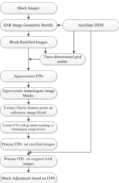
The matching method aimed to solve the problems of multi-image matching for SAR Block Adjustment, such as different resolutions, severe relative geometric distortion, uncertain relative positon of match points, difficulty of matching in non-feature area and large amount of computation. The method takes full advantage of SAR image geometric information, feature information, gray-correlated information and external auxiliary terrain information for SAR image matching. The method mainly contains the follow parts: At first, original SAR images were geometric-rectified according to SAR geometric imaging model with existed Digital Elevation Model (DEM) for external auxiliary terrain information. Relative geometric distortion between images could be reduced by rectifying, and resolution would be uniform. Then, grid points with 3-D coordinates were obtained according to geographic coordinates of rectified images and height from DEM. The 3-D points were calculated with a certain ground interval in X-Y directions. Image points on the rectified images would be got from the ground points. Every 3-D ground point would correspond to a group of image points. After that, a master image point is selected for every image point group. Feature point near the master point was extracted by feature detection for the match reference point. The homologous points on rectified images could be obtained by accurate image matching with the reference point. At last, the homologous points on rectified images were transferred to image points of original SAR images as the ITPs of Block Adjustment. The technical process is as Figure 1.
Figure 1. Automatic Extraction of ITPs
2.1 Image rectify based on geometric information and external auxiliary terrain information
In a SAR image block, there are relative geometric distortion, different scales and different directions of feature between different images which observed a ground object from different incidence angle (He, 2013). There are unfavourable to feature-correlation and gray-feature-correlation. The relative geometric distortion between SAR images cannot be fitted as optical images with polynomial. The distortion follows from the range projection. In this paper, geometric rectification was used to overcome these disadvantages and improve the possibility and precision of SAR multi-image matching.
The rectification was based on the SAR geometric geolocation model combining with external auxiliary terrain information that was the existed DEM. Generally, the current high-resolution SAR system can provide high-precision sensor platform tracks. Using SAR imaging parameters and the tracks, geometric geolocation model could be established. Then SAR image could be rectified with DEM. Geometric distortion would be reduced and image spatial scale consistent.
As showed in Figure 2, a ground object was observed from four different positions. The four images were coded with WE_01_05 , WE_04_05, EW_02_05 and EW_02_05.
WE_01_05 and WE_04_05 was observed from the same side with different incidence angles, while EW_02_05 and EW_02_05 from the other side. The shapes and scales of the object on different images were quite different. After rectification, the differences were reduced effectively and the homologous point matching would be improved.
Figure 2. Homologous Image blocks on SAR images
Figure 3. Blocks on rectified images
2.2 Acquiring approximate ITPs based on external auxiliary terrain information
The determination of initial spatial relationship between homologous image points was difficult. A solution was using quick feature matching with look images. But for multi-image matching of SAR Block Adjustment, the computation would take match time and the reliability is not stable. It is efficient and reliable method using the geographic information.
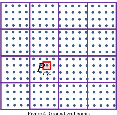
After rectification, the rectified images had geographic information and the geographic bound of the block was got. 3-D ground grid point could be obtained with a certain ground interval combing with DEM. If the Gauss plane coordinates of left-top corner of this area were , the ground intervals
were , then plane coordinates the grid point
located in rows and cols were and :
The height could be interpolated from DEM with
, the 3-D point was got. According
the geographic information of rectified images, the 3-D point could be transferred to image points of rectified images. For every 3-D point, a series of image points will be acquired. For
the grid point , images would be involved and m image
points which were called by 1
,
2,....,
mFigure 4. Ground grid points
In the method of this paper, image blocks were clipped from the rectified image with a certain width and height. The centers of image blocks were the approximate homologous image points. For every group of points, a group of image blocks called by homologous image blacks could be obtained and correspond to the same ground area. For approximate homologous image
points
I
P1,
I
P2,....,
I
Pm corresponding to grid pointP
r c, , it is possible to obtain image block groupB
P1,
B
P2,....,
B
Pm.2.3 Extracting match reference point for homologous image blocks with image feature information
For every group approximate homologous image points, one of them was selected as master match point (reference point of matching) and every other point would be matched to it accurately. Then precise homologous points can be obtained. But the image point calculated from the ground grid point may be located at non-feature point. So feature point near the image point would be extracted as the match reference point to avoid match failure. For the approximate homologous image points
1 2
,
,....,
mP P P
I
I
I
, ifI
Pk(1
≤ ≤
k
m
)
was selected as the master point, the feature point was extracted from the image blockB
Pk as the reference point.In this paper, Harris detection operator was used to extract feature point from the master image block as the reference point. The basic principle of Harris algorithm is: a small window is selected with the interest image point as center point. Gray change of the window was calculated when it moved along any direction. And gray change was expressed with a formula. If the window whose center was image point
( , )
x y
movedu
(pixels) alongx
direction andv
(pixels) alongy
direction, the gray change calculated by Harris is expressed as follow:Response function value is the interest value of feature extraction. In the reference image block, the point with the greatest interest value is extracted as reference point.
2.4 Extracting ITPs with pyramid matching based on gray-related information
For each group of homologous image blocks, homologous image point corresponding to matching reference point the on every image block was obtained by pyramid matching. After processing all groups of image blocks, ITPs of the block on rectified were extracted. For image block group 1
,
2,....,
mP P P
B
B
B
,B
Pk was selected for the masterblock, and the reference point k P ref
I
was extracted. Accurate homologous image pointsI
P mat1,
I
P mat2,....,
I
Pmmat were obtained after matching.2.5 Transferring ITPs from rectified images to original SAR images
At last, the homologous image points on the rectified images would be transferred to homologous image points on the original SAR images according to the geo-location model assisted by the existed DEM. The ITPS of Block Adjustment
,
r c
P
were extracted. For the match point Re
k P c
I
on the rectified image, its plane coordinatesRe Re
(X c,Y c) can be calculated according to the geographic information of rectified image. Then its height
Re c
H could be interpolated from DEM and 3-D
coordinates
Re Re Re
(X c,Y c,H c) were got. After that, image
coordinates
(
x
SAR,
y
SAR)
of the match image pointI
P SARk on original SAR image were calculated according to the geo-location model. Every point was processed as this, and homologous image points which were ITPS were obtained.3. EXPERIMENTS
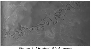
In the experiment, X band airborne SAR images acquired by Chinese airborne SAR system——CASMSAR system were used to make up the block. The study area was located at Ruoergai, Sichuan Province. The SAR data contained 11 strips. There were 440 SAR images totally when every strip contained 20 images. The width (showed in Fig.4) of the SAR image 16384, the height is 8192, and the resolution is 0.5m. The overlap between images is more than 60%. There were two side-looking observations. One side-looking was from north to south when the aircraft flight from east to west, and the other was from south to north when the aircraft flight from west to east. The Image is showed as in Figure 5.
Figure 5. Original SAR image
Auxiliary DEM used in matching was existed DEM of 1:50 000 scale. Its resolution was 25m, and height accuracy was better than 14m. The accuracy of the platform track data acquired by Position and Orientation System (POS) of CASMSAR was better than 2m after post-treatment。According to geo-location
model of SAR image, the images could be rectified with DEM
and platform track data. The rectified image is showed in Figure 6.
Figure 6. Rectified image
According to the above matching process, match points were extracted from all of the images. The points of the above image were showed in Figure 7.
Figure 7. ITPs extracted on the image
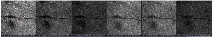
The bound of the images and distribution of ITPs were showed in Figure 8. A total of 652 ITPs (Showed in Fig.5) were extracted using the method of this paper for the block. Block adjustment was carried out using these ITPs. The root mean square of image point residuals was in azimuth 3.1 pixels, and in range 2.7 pixels. The result could meet the precision needs of 1:10 000 scale mapping. One group ITPs on six SAR images were showed in Figure 9.
Figure 8. Block ITPs extracted automatically
Figure 9. A Image Tie Point on six SAR images
4. CONCLUSION
For the ITPs extraction of SAR Block Adjustment automatically, this paper proposed a method of SAR image matching integrating multi-information. It takes full advantage of SAR image geometric information, feature information, gray-related information and external auxiliary terrain information for SAR image matching. Experiments were carried out with SAR images acquired by Chinese airborne SAR system——CASMSAR system. ITPs were extracted and precision was evaluated by adjustment solution. The result had showed that the method is effective for block adjustment of SAR data. And the matching method has been applied in western China's 1: 10,000 scale topographic mapping. It improves data processing efficiency effectively, and means great significance for promotion of SAR mapping applications.
ACKNOWLEDGEMENTS (OPTIONAL)
The paper was supported by Special Fund by Surveying & Mapping and Geoinformation Research in the Public Interest (201412002) and Fundamental Research Funds for CASM (7771303).
REFERENCES
Zhang J., Yang S., Zhao Z., et al., 2010. SAR mapping technology and its application in difficulty terrain area[C]// Geoscience and Remote Sensing Symposium (IGARSS), 2010 IEEE International, pp. 3608 - 3611.
Leberl F., Maurice K., Thomas J., et al. , 1994. Automated Radar Image Matching Experiment[J]. ISPRS Journal of Photogrammetry and Remote Sensing, 49(3), pp. 19-33.
Yoon K, Kweon I. , 2005. Locally Adaptive Support-weight Approach for Visual Correspondence Search[C]//IEEE Computer Society Conference on Computer Vision and Pattern Recognition, 2005. CVPR 2005. IEEE, 2, pp. 924-931.
Faugeras O., Hotz B., Mathieu H., et al., 2013. Real Time Correlation-based Stereo: Algorithm, Implementations and Applications[R]. Technical Report RR-2013, INRIA, 1993.
Gutjahr K., Perko R., Raggam H., 2014. “The epipolarity constraint in stereo-radargrammetric DEM generation,” IEEE Trans. Geosci. Remote Sens., vol. 52, no.8, pp. 5014– 5022.
He X., Zhang L., Balz T. et al., 2013. Topographic Mapping in Mountainous Areas Using StereoSAR Assisted by External DEM[J]. Acta Geodaeticaet Cartographica Sinica, 42(3), pp. 425-432.