CROP SPECIES RECOGNITION AND DISCRIMINATION PADDY-RICE-GROWING-
FIELDS FROM REAPED-FIELDS BY THE RADAR VEGETATION INDEX (RVI) OF
ALOS-2/PALSAR2
Y. Yamada a
a Institute for Rural Engineering, National Agriculture and Food Research Organization, 2-1-6 Kannondai, Tsukuba, Japan -
Commission VIII, WG VIII/8
KEY WORDS: radar vegetation index, RVI, ALOS-2, PALSAR2, crop, biomass, rice, paddy fields
ABSTRACT:
The Japanese ALOS-2 satellite was launched on May 24th, 2014. It has the L-band SAR, PALSAR-2. Kim,Y. and van Zyl, J.J.
proposed a kind of Radar Vegetation Index (RVI) as RVI = 8 * σ0
hv / (σ0hh + σ0vv + 2*σ0hv) by L-band full-polarimetric radar
Odd
Dbl
Vol
Hlx
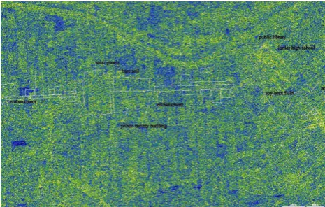
Figure 7. RVI result at the north side of the Tone river and the overlaid-gound-survey-map
Figure 8. Zooming the RVI result of upper left part of Figure 7. image
Figure 9. Zooming the RVI result of middle part of Figure 7. image
Figure 10. Zooming the RVI result of upper right part of Figure 7. image
Figure 11. the RVI result of the south side of the Tone river
7. FINDINGS AND DISCUSSION
Kim,Y., Jackson,T., et al., 2012,Radar Vegetation Index
for Estimating the Vegetation Water Content of Rice and
Soybean,
IEEE Geo. Remote Sens. Letters
, Vol.9, No.4,
564-568
Kim,Y., Jackson,T., et al., 2014, Retrieval of Wheat
Growth Parameters With Radar Vegetation Indices,
IEEE Geo. and Remote Sens. Letters
, Vol.11, No.4,
808-812
Ministry of Agriculture, Forestry and Fisheries of Japan
a,
https://www.s.affrc.go.jp/docs/report/report15/no15_p1.h
tm (Viewing on April 11th, 2016, partially edited.)
Ministry of Agriculture, Forestry and Fisheries of Japan
b,
http://www.maff.go.jp/j/agri_school/a_menu/oseti/04.ht
ml (Viewing on April 11th, 2016, partially edited.)
Yamada,Y., 2015,PRELIMINARY STUDY ON
THE RADAR VEGETATION INDEX (RVI)
APPLICATION TO ACTUAL PADDY FIELDS BY
ALOS/PALSAR FULL-POLARIMETRY SAR DATA,
Proc. of 36
thISRSE
,166-1, 166-3
The International Archives of the Photogrammetry, Remote Sensing and Spatial Information Sciences, Volume XLI-B8, 2016 XXIII ISPRS Congress, 12–19 July 2016, Prague, Czech Republic
This contribution has been peer-reviewed.