isprs archives XLI B5 895 2016
Teks penuh
Gambar
Garis besar
Dokumen terkait
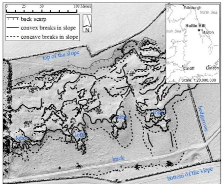
The produced 3D point clouds are gridded to 6 mm resolution from which topographic parameters such as slope, aspect and roughness are derived.. At a later project stage these
The main steps of automated measurement process are the following: accurate 3D reconstruction of teeth arch, 3D model segmentation into a set of separate teeth,
In this paper, basic considerations, which are based on the ex- perience made on three test sites, for the usage of cameras for construction progress monitoring using
For the volume of concrete estimation and thickness calculation, the signed distances from the initial to the successive point cloud were obtained using Cloud Compare.. In this
This paper presents an algorithm for the automatic registration of terrestrial point clouds by match selection using an efficiently conditional sampling method --
Figure 17 – A difference Digital Elevation Model (GSD 1m) derived from the Pleiades DEM of the Makhmúr al - Qadíma site with overlaid objects of interest on the right picture.. In
Two examples are presented here: a point cloud derived from Phantom 4 UAS images of the historic dock at Wormsloe; and second, the integration of aerial and terrestrial LiDAR
The change detection methodology proposed in this paper is aimed at increasing the timeliness for the production of detailed damage assessment maps in CH sites in sensible areas
