isprsannals II 3 W5 459 2015
Teks penuh
Gambar
Garis besar
Dokumen terkait
Automatic tie points, GCPs, and camera centres shown in rayCloud Editor (top) and the dense point cloud (bottom) for the 8mm dataset.. 2.4.4.2 Fisheye Lens 10 mm: This set
Result at the system level Overall, we load several billion points into the point cloud server, perform several processing in and out of base ( s to hour), extensively use simple
Our approach is independent on initial values for the unknowns, very robust against outliers in relative rotations and homologous points and reaches good results on syn- thetic as
Figure 2: Separating nearby buildings: (a) input (non-ground) point cloud data, (b) extracted building footprint (buildings are merged), (c) corresponding building mask, (d)
Instead of classical granular computing algorithm which extracts the possible granules of the data and then attempts to extract the classification rules, we proposed a
Generally, a filtering of raw point cloud data in terms of removing 3D points corresponding to unreliable range measurements may be based on intensity information (Barnea and
These rectangles are eroded using mathematical morphology operators (Heijmans and Ronse, 1990) so that the markers for each stone are obtained. Figure 2d represents the
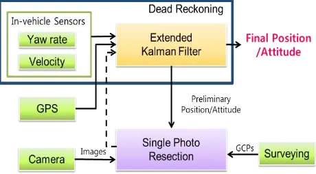
In addition to the visual approach, photogrammetry has to be supported by a topographical survey (to acquire ground control points - GCP) to georeference all the finds in
