isprsarchives XL 7 W3 1367 2015
Teks penuh
Gambar


Garis besar
Dokumen terkait
With the above research achievement, some of them construct distribute GIS platforms by Hadoop (Liu, 2009; Chen, 2010; Aji, 2013).There are a few researches proposed for processing
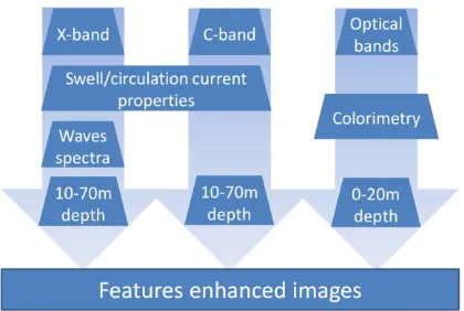
Consequently, the fusion of Optical imagery, SAR imagery and interferometric information, 3D surface model and motion vector products yields a suite of products where
Applications to derive maritime value added products like oil spill and ship detection based on remote sensing SAR image data are being developed and integrated at the
The algorithms are based on analysis of image spectra and use parameters fitted with collocated buoy data and sea state model results using also information on spectra
Pattern Analysis and Machine Intelligence , 23(11), pp. An experimental comparison of min-cut/ max-flow algorithms for energy minimization in vision. Maximal flow through a
After coordinate transformation and merging of data, candidate landslide representing pixels of high quality radar signals were filtered out by applying a GIS
1997, Remote sensing, geographic information systems (GIS) and Bayesian knowledge-based methods for monitoring land condition. School of Computing, Curtin University
The improved and automated method for grassland cutting date detection based on Sentinel-1 radar data will be integrated in a grassland yield and quality model such as used
