Conference paper
Teks penuh
Gambar
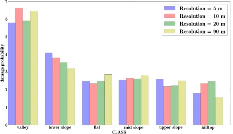
![Figure 8: Variance in number of affected households per class [%] for different resolutions](https://thumb-ap.123doks.com/thumbv2/123dok/3256315.1399219/8.595.98.501.254.572/figure-variance-number-affected-households-class-different-resolutions.webp)
Garis besar
Dokumen terkait
Using seven basic features of mean layer values such as Blue, Green, Red, Infrared, Pan, Brightness and Maximum difference, a vegetation index as the Soil Adjusted Vegetation
Imaging spectroscopy (IS), or hyperspectral remote sensing (HRS), is an advanced tool that provides high spectral resolution data in an image, with the aim of
Historical data is a prime input for temporal studies using remote sensing technology. For most of the country, historic data in high resolution is not available for
The University of North Georgia (UNG) is a public comprehensive university that has the Institute of Environmental Spatial Analysis (IESA) that is dedicated to
Differential Absorption Lidar (DIAL) which is based on the difference in the absorption with wavelengths is the powerful technique for the measurement of the
For this purpose, spatial distribution maps of all fertility parameters in soil obtained by ordinary Kriging based on exponential model for surface (0 – 15cm) soil
Methodology adopted in the project is based on the estimating building height using shadow analysis technique from single high resolution QUICKBIRD satellite data
bands with a spectral sampling of 2 - 3nm at the blue end of the spectrum to 12nm at the 1050nm range and a spatial resolution of 17m. These multiangle viewing images can be used
