UTILISATION OF SATELLITE DATA IN IDENTIFICATION OF GEOMORPHIC
LANDFORM AND ITS ROLE IN ARSENIC RELEASE IN GROUNDWATER.
R. P. Singha * , N. Singh a, S. Shashtri a, S. Mukherjee a
a
School of Environmental Sciences, Jawaharlal Nehru University New Delhi 110067 - (singhravi004, hereisneha.singh, sn.shashtri, saumitramukherjee3)@gmail.com
KEY WORDS: Geomorphology, GIS, Groundwater, Arsenic, Slope,
ABSTRACT:
The present study was conducted to explore the influence of geomorphic features of the area on the mobilization of arsenic in groundwater. In this study, remote sensing and GIS techniques were used to prepare the geomorphic and slope map of the area. Different geomorphic features were identified on the basis of spectral signature on the LISS III and Landsat satellite image and field survey. Groundwater samples were collected from each representative geomorphic feature to inspect the arsenic contamination in the area. The study area is drained by the Brahmaputra river and its tributaries and contain mainly fluvial geomorphic units especially older flood plain, palaeochannels, oxbow lakes, channel islands; and hilly areas at some of the places. In this study it was observed that enrichment of arsenic in groundwater varies along the geomorphic units in following trends Paleochannel> Younger alluvial plain> Active flood plain> channel island > dissected hills. The above trend shows that a higher concentration of arsenic is found in the groundwater samples collected from the fluvial landforms as compared to those collected from structural landforms. Brahmaputra River and its tributaries carry the sediment load from the Himalayan foothills, which get deposited in these features during the lateral shift of the river’s courses. Arsenic bearing minerals may get transported through river and deposit in the geomorphological features along with organic matter. The flat terrain of the area as seen from the slope map provides more residence time to water to infiltrate into the aquifer. The microbial degradation of organic matter generates the reducing environment and facilitates the dissolution of iron hydroxide thus releasing the adsorbed arsenic into the groundwater.
1. INTRODUCTION
Contamination of drinking water is an environmental challenge which has affected the livelihood of millions of population.( Gaus et al.,2003) Arsenic problem is common to several alluvial plains of South and East Asia as it has been reported in many fluvio-deltaic tracts of the world like Hanoi City and the upper end of Red River Delta (Berg et al., 2001), Tarai belt of Nepal (Gurung et al., 2005), Indus delta of Pakistan (Khan et al., 2010), delta plains of the Mekong river in Cambodia (Polya et al., 2005). In India arsenic enrichment in groundwater has been reported in the Ganga-Brahmaputra river plain (Das et al., 1996) and a number of studies have been conducted in West Bengal and Bangladesh related to the arsenic mobilization in groundwater and its correlation with other affecting parameters (Mukherjee et al., 2005; McArthur et al., 2001; Nickson et al., 2000; Chowdhury et al., 1999; Chakraborti et al., 1996). Continuous exposure to arsenic contaminated groundwater may cause conjunctivitis, hyper pigmentation, painful skin blisters on human body even causing gangrene of the limbs, and the skin cancer.
Regional occurrence of arsenic in West Bengal and Bangladesh is mostly attributed to the geogenic source which releases the arsenic in groundwater through natural hydrochemical processes occurring in the study area (Nickson et al., 2000; Bhattacharya et al., 1997). There are several hypotheses regarding the enhanced concentration of arsenic in groundwater but the most accepted hypothesis is reductive dissolution of iron hydroxide (FeOOH), which release the adsorbed arsenic in the aquatic environment (Bhattacharya et al., 2006; McArthur et al., 2004). However identification of source of arsenic is still a matter of study, but some researchers have identified the Himalayan rock as a primary source of arsenic which comes along the river and get deposited in plain areas (Acharyya and Shah, 2007; McArthur et al., 2001). The arsenic enriched groundwater is mainly restricted to the Holocene aquifer at shallow and
intermediate depth (Ahmed et al., 2001; Mukherjee and Bhattacharya, 2001). Although arsenic has been extensively studied in West Bengal and Bangladesh but northeastern part of India is also not immune from arsenic contamination. The presence of arsenic has been identified in Assam, Tripura, Arunachal Pradesh, Manipur and Nagaland too (Mukherjee et al., 2006). Assam is an adjoining state of West Bengal with similar hydrogeological pattern. Assam is yet to get attention, though several studies have been done which reported arsenic contamination in the groundwater of 21 districts out of 24 (Singh, 2004; Sailo and Mahanta, 2013).
Remote sensing provides quick and useful information about parameters controlling the occurrence and movement of groundwater like soils, geomorphology, geology, lithology; land use/cover, lineaments etc. (Mukherjee et al., 2005; Todd, 1980). Remote sensing and GIS technology has proved to be an important tool in assessment of geomorphic features. Geomorphology of an area has a significant influence over arsenic enrichment in ground water. Ravenscroft et al. (2001) has shown that the occurrence of arsenic has a close relation to geomorphological units. In the present study, geomorphic features were identified in the Bongaigaon and Goalpara districts of lower Western Assam using satellite images. The groundwater samples were collected from each geomorphic unit and were analyzed to understand the groundwater chemistry and to study the influence of geomorphic features on the mobilization of arsenic in the groundwater of the area.
2. STUDY AREA
The study area (Bongaigaon and Goalpara districts) lies in the lower western part of the Assam (Fig.1), and is occupied by both hills and plains. Both districts are situated in the Foreland depression between the comparatively younger mountain chains of the Himalayas in the north and the Block Mountains of Shillong plateau in the south. The geological formations in the ISPRS Annals of the Photogrammetry, Remote Sensing and Spatial Information Sciences, Volume II-8, 2014
area are the Hornblende g granite with p alluvial forma with occasion silt, clay and p alluvial sedim groundwater in The annual ra cm from plac 4°C to 19°C d The maximum minimum tem The Brahmapu in the Brahm controlled by river system Jinjiram, Jinar the area towar Manas, Aie, C rivers flowing the form of lo controlled by parallel to the are also prese large rivers. T cover the co load of sedim for the reduct leading to fre
Figure.1. Stud
Landsat imag area were fro image with sp Remote sensin was done to th through visual structure of th (LISS III/Lan truthing. Geom and thematic m The geomorph features and su
Archean gro gneiss, granulit egmatites. The ations compose nal clay. The flo pebble deposite ments of the qua
n the area. infall in the sta ce to place The during winter a m temperature i mperature falls u utra flows sout maputra valley
two different sy consisting of ri and Deosila) rds the east. Al Champa, Gaura g east to west, ocal meanders.
Jinrana river, e Brahmaputra ent originating The courses of nsiderable are ments derived fr tion in the d equent flood d
dy area (LISS II
3. MATER ges (2006) with om USGS web atial resolution ng centre (NRS he images. Geom
l interpretation he features on ndsat), and fie morphic feature map was genera hic features hav ub-features. Slo
oup of rock c es, schists whi area is largely ed of sand, gr ood plain area ed by the river), aternary age are
ate varies betwe e average temp and 26°C to 37 is 33°C during up to 7°C in th th-westward an y. The draina ystems of river f tributaries ( of the mighty ll the rivers are ang, Tipkai and
also having no To the west o which flows in River. A numb from marshy l f large rivers a of the Goa rom the Himala drainage capa during the mon
II satellite imag
RIAL AND ME spatial resoluti bsite and LISS n 23.5m was obt SC) and require morphological n on the basis o n the multi- da eld work was es were digitize ated by using A ve been identifi ope map was pr
comprising Bi ich are intrude covered with r ravels, and bou
(comprises of , piedmont zone e a good reserv
een 160 cm and perature varies 7°C during sum g July and Aug he month of Jan nd then towards age of the ar rs. Northerly flo (Dudhnoi, Kris Brahmaputra d e perennial in n
d Gangadhar ar orth-south cour of Agia, draina n westerly dire ber of small str land, and joini and marshy alpara district. ayas are respon acity of the nsoon season.
ge)
ETHODS ion 30m of the S-III (2006) sa tained from Na ed image proce
units were iden of tone, texture ate satellite im s done for gr ed at 1: 50,000 Arc GIS 10 soft
ied at three lev repared from Sh
iotite-ar Topography r correcting the
e data. y-five groundw morphic unit as
was used to undwater sampl ps of two distri am. Water sam es (Tarsons). undwater to be s
few strokes of he iron content
Samples collec ons and trace m ottle was non a electrical cond x potential (Eh samples were ught to the labo HA, 2005). Sa r paper using
ride were analy ride ion selectiv a were analyse mbda 35) follow
yzed on Flam litative analysis done using trophotometer undwater measu
4. RE Geomorpholog Geomorpholog tifying the vari he basis of tone ures. The study morphic feature in (alluvial plai present in majo hly, moderately es. The bar gra ures (Fig.2) sho ered with older r course perio ochannel, back form features o nnel islands, bra
ure.2. Area cove y area
Mission data images by rem
water samples s inferred on t
map the loca les were collec icts (Bongaigao mple were colle Bottles wer sampled. Durin water were disc
of pipes throu cted in the bottl metals analysis acidified and use ductivity (EC), h) were measur stored in styr oratory and kep amples were f
vacuum filtra yzed using titr ve electrode, ph ed using spect wing APHA. S me photometer
s of calcium, m Thermo sc (AAS). The ured through Ph
ESULTS AND D gy of the area gical map of th ious geomorphi e, texture, shape y area contains es. The geomo in, older flood or part of the a y and low disse aph of area cov
ows that the m r flood plain. T odically and th kswamp, aband of the older floo aided bars
ered by differen
downloaded fr moving the smal
were collect the satellite im ation of each s cted from tube w
oun and Goalpa ected in clean re rinsed 2-3 ng sampling from
carded to minim ugh which wate
le (125 ml) we and samples co ed for anion an
total dissolved red onsite with rofoam boxes pt at 4°C for f filtered with 0 ation unit. Bi ration method, hosphate, sulph trophotometer Sodium and p r (Elico flame magnesium, iro cientific atom
saturation of hreeqe software
DISCUSSION
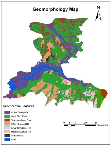
he study area w ic units and the e, size and arra
mainly fluvial orphic features
plain and activ area while of st
ected hill) are vered by differe major part of th
The rivers of he remnant o doned channels od plain (Fig.3
nt geomorphic
rom the USGS ll imperfections
ed from each magery. Garmin sampling sites. wells and hand ara) of Western polypropylene 3 times with m hand pumps, mize the impact er was pumped re acidified for ollected in 250 nalysis. d solids (TDS), h the electrode. and then were further analysis .45µ Millipore icarbonate and fluoride using hate, nitrate and (Perkin Elmer potassium were e photometer). on and arsenic mic absorption f minerals in
(USGS).
N
was prepared by eir components angement of the l and structural of the fluvial ve flood plain) tructural origin at some of the ent geomorphic e study area is Assam change of rivers form s as prominent ). Features like
features in the S ISPRS Annals of the Photogrammetry, Remote Sensing and Spatial Information Sciences, Volume II-8, 2014
are formed in the regions which frequently experiences flooding and comes under the active flood plain of the area. The Brahamputra basin have the deposition of sediments from the river and their tributaries, with the visible presence of numerous palaeochannels, oxbow lakes, and flood plains.
Figure.3. Geomorphology map of the study area
4.2. Groundwater Chemistry
The results of the groundwater quality have been tabulated in the form of maximum, minimum and mean (Table 1). pH of the groundwater in the study area is slightly acidic to alkaline in nature and the value ranges between 6.8 to 8.4. The electrical conductivity is defined as the ability of a substance to conduct electric current which depends upon dissolution of minerals in the sampled area. The mean value of electrical conductivity in the groundwater samples is 269.7 ± 64.1 μmhos/cm, and TDS value is 188.8 ± 44.9 mg/L which indicates that the water samples are mineralized. The results of ground water samples indicate the dominance of cations in the order of Na+>Ca2+>Mg2+>K+ while in the anions bicarbonate dominates in the samples followed by chloride, and nitrate HCO3->Cl ->NO3->SO42-
4.3. Mobilization of arsenic in groundwater
Out of 45 groundwater samples collected from each geomorphic unit, 8 samples have concentration higher than WHO permissible limit of 10 ppb (Fig.5). The arsenic enrichment is found in the groundwater samples collected from the areas lying along or near the flowing and dry rivers. The geography of study area shows that the area is drained by several rivers from both sides of the Brahmaputra, and arsenic concentration is found to be higher mainly along the river (Manas, Aie) coming
from northern Himalayan foothills. (Fig.4) The flood plain sediments drained by the rivers originating from the Himalayan Mountains and Tibetan Plateau are expected to contain arsenic as these are reported to be the geological origin of arsenic in South Asia (Das et al., 2008). The sediments and mineralogy of the basin depend on the type of sediments eroded and transported by the Brahmaputra river and its tributaries. Local geology, geomorphology, hydrogeology, geochemistry of sediments influences the occurrence, origin and mobilization of arsenic in sedimentary aquifers (Bhattacharya et al., 1997; Kinniburgh and Smedley, 2001).
Table 1. All Concentration in mg/L, except EC (µS/cm), pH and As (ppb)
4.3.1. Variations of Arsenic concentration in different Geomorphic features.
Enrichment of arsenic in groundwater varies along the geomorphic units in following trends Paleochannel> Younger alluvial plain> Active flood plain> channel island > dissected hills (Table 2). The above trend shows that a higher concentration of arsenic is found in the groundwater samples collected from the fluvial landforms as compared to those collected from structural landforms (Fig.5). The occurrence of arsenic in alluvial plain is usual (Welch et al., 1988) and its enrichment is associated with Holocene sediment brought by rivers originated from Himalayas (Ahamed et al., 2006; Chakraborti et al., 2002; McArthur et al., 2004).
In the present study, it was found that the groundwater samples collected from paleochannel geomorphic features have higher arsenic concentration. Palaeochannels are the remnant geomorphic unit formed through the lateral shift of the rivers. Brahmaputra plain is covered by younger alluvial sediments at most of the places deposited from the sediment load carried by the river and its tributaries (Sarma and Phukan, 2004). The Brahmaputra is a braided stream showing the rapid lateral migration of as much as 800 m/year (Allison, 1998).
The Brahmaputra river originates from the eastern part of the Mansarovar Lake in the Tibetan Plateau between the Kailash range and the Himalayan range and flows through China, India Parameters Max Min Mean+Std.dev
pH 8.4 6.8 7.7 ± 0.4
EC 405 146 269.7 ± 64.1
TDS 283.8 102.6 188.8 ± 44.9
Na+ 30.9 4.5 13.8 ± 7.3
K+ 9.1 1.2 3.3 ± 1.5
Ca2+ 34.4 1.2 10.6 ± 6.3
Mg 2+ 17.9 2.2 7.3 ± 3.6
HCO3 - 210.8 61 118.5 ± 31.0
F - 3 0.1 1.1 ± 0.7
Cl - 36.8 7.2 15.6 ± 6.5
SO42- 3.5 0.2 1.1 ± 0.8
NO3- 16.2 1.1 4.4 ± 3.2
PO4
3-2.4 0.1 0.766 ± 0.5
SiO2 15.4 2.3 7.8 ± 3.3
Fe 20.9 0.1 4.3 ± 4.3
As (Total) 20.3 0.5 3.8 ± 4.3 ISPRS Annals of the Photogrammetry, Remote Sensing and Spatial Information Sciences, Volume II-8, 2014
and Banglade types, includ intrusive, P limestones of Mukherjee et sediments deri from the ol hydrodynamic particles get d channel aband cover (Shankm The Himalaya during the H transportation (Gasse et al., are vulnerable Arsenic may h derived from association wi the river solu natural and an the concentrat Geomorphic features Older flood pl Paleochannel Active Flood Plain Channel island Younger Alluvial Plain Mod/Highly dissected hills
sh. The Brahm ding Precambr Paleozoic-Mesoz f the Himalay al., 2009). The ived from the y lder Assam c condition of
ment load) f ls, abandoned c
nic concentration
senic contamina
t of organic m deposited due t doned with the man, 1991). a was subjected
Holocene tim of arsenic bea 1991). Aquife e to arsenic cont have been depo m the Himalay ith insoluble ph ute load (Stum nthropogenicall tion of arsenic a
Sample
maputra flows th rian metamor zoic sandsto yan terrain (S
northern bank young Himalaya
plateau (Kun the river (stre forms geomor
hannels, oxbow
n in different ge
ation in the stud
matter, fine gra to swampy con e development
to high erosion e, thus erosi aring products i ers containing H
tamination (Mc osited with oth yas, which h hases like cryst mmeyer et al., ly derived orga and other trace es rphic rocks, nes, shales Sarin et al.,
of the river rec as while, south nte, 1988). V
eam movemen rphic features w lakes.
eomorphic feat
dy area
ained colloidal ndition in the c of large vege
n and intense ra ion, oxidation in solution was Holocene sedim cArthur et al., 2 her fluvial sedim has been foun
talline iron oxid 2002). Presen anic matter regu
metals. Low su Min. M ssociated with
(2002), Clark ocene alluvial
te very favoura fers are mostly
ure.5. Arsenic c erent geomorphi
FP- Older Flo od Plain; CI- Ch
ure, compositio g the plain depe ing to spatio-tem terially catalyz
er create the hi ctive dissolutio ed arsenic into Arthur et al., 20
eochannels are cing aquifer i iated reductive onsible for ars 4
ests anoxic con oxidation of or and Fritz (1 sediments are able conditions
reducing in nat
contamination in ic units
ood Plain; PC hanel Island; YA
on and distribu ending on the t mporal variabil zed oxidative b
ghly anaerobic on of iron oxy h the groundwat 001). The Redu e generally low
in the subsurf e dissolution o enic release in
F CO H2 3 4
7 →
+
Eh variations in
ion is mostly s in the study posited by the r
ndition of the aq rganic matter. B 1997) have sh rich in organ s for reducing
ture (Akai et al.
n the groundwa
C-Paleochannel; YAP- Younger A
ution of organ type of depositi lity of their red breakdown of
condition thus hydroxides, thu ter (Bhattachar uction potential w indicating th face (Fig.6). of Fe-oxyhydro n ground water
HCO
y controlled b area as organic river act as the
quifer and may Bhattacharya et hown that the nic matter and bacteria as the ., 2004).
ater samples in
; AFP- Active Alluvial Plain)
ic matter vary ion by the river duction process. these organic facilitating the us releasing the rya et al. 1997; (Eh) values in he presence of The microbial oxides may be r (Islam et al.,
by the redox-c matter in the major electron ISPRS Annals of the Photogrammetry, Remote Sensing and Spatial Information Sciences, Volume II-8, 2014
acceptor. Decr the groundwat of bicarbonate reduction in th Low nitrate an microbially m
Slope map (Fi between 0 to plain where sl in hilly area w slope varies fr very steep (27 runoff and availability an very less slop features enoug providing the groundwater.
−
+
24
2
C
SO
rease in the con ter samples wit e (Fig.7) is the he presence of o
nd sulfate in th mediated reducti iments. The red
s
→
2
O
2
CH
atter plot of con bonate
. Slope in the st
ig.8) shows tha 53.9°. The ar lope is very les which lies at bo rom low (8.2° – 7.9° – 53.9°). S infiltration an nd quality in an pe provide the
gh time to inf pathway for t
→
2
O
2
H
CH
ncentration of n th an increase e evidence of m
organic matter he groundwater
ion of organic m duction of nitrat
+
2
5
HCO
N
ncentration of S
tudy area
at the slope of th ea is mostly o ss varying betw oth the bank of – 12.9°), modera Slope has an in
nd determines n area. Flat terr surface water i filtrate deep in the contaminan
+
2
S
2
HCO
H
nitrate and sulf in the concentr microbially med (Halim et al., 2 can be attribut matter present i te and sulfate c
− 3
O
Sulphate and N
he study area r occupied by al ween 0 to 8.2°, f Brahmaputra ate (17.5° - 22. fluence over su s the ground rain of the area in these geomo nto the aquifer, nt to reach int
−
e fluvial geom easily undergo
be responsib cerned aquifer
nic is mobiliz hydroxides but ween iron and ar which is non tions and preci o and Mahanta,
Figure.9. Scatte
mineral satura in the groundw eqe software (U
SI = log (IAP/K
ere, IAP = Ion a equilibrium so
0 indicates und roundwater with results of miner ration of halite mite, calcite, an roundwater sam
ure.10. Saturatio
enic enriched g presence of ipitation of iron
− +
+
2
HCO
3 2
ipitation of sid undwater (Dow ained the poor undwater.
onclusions
morphic units c es microbial re ble for the en (Enmark and zed through r
existing data d rsenic (Fig.9). T n conservatory
ipitates as side 2013).
r plot of Arseni
ation indices on water samples h USGS) by using
Kt)
activity product olubility constan
dersaturation, a h respect to par ral saturation sh
and CO2 (g) i nd quartz show mples collected (
on Indices of gr
groundwater is iron reducin n as siderite (Sa
−
→
FeCO
3 3derite will remo wling et al., 20
statistical corre
contain higher eduction, the ab nrichment of a Nordborg, 20 reductive disso does not show
This may be po y may be invo erite (Welch an
ic concentration
n the basis of have been deter g the following
of the dissocia nt.
and >1 reflects rticular mineral.
how the high de n groundwater ws a good degre
(Fig.10).
roundwater
s supersaturated ng bacteria aunders and Sw
+
siderite
)
(
3
ove iron relativ 002), This pen elation for iron
organic matter bove processes arsenic in the 007). Although olution of Fe-any correlation ossible because olved in other nd Lico, 1998;
n versus Iron
egree of under-while siderite, ee of saturation
d with siderite facilitates the ann, 1992).
+
+
2
H
ve to arsenic in nhamena have n and arsenic in r ISPRS Annals of the Photogrammetry, Remote Sensing and Spatial Information Sciences, Volume II-8, 2014
The groundwater collected from geomorphic units were slightly acidic to alkaline in nature with most of the parameters well within the permissible limit of WHO except for fluoride, iron and arsenic. Arsenic concentration was found to be higher in the samples collected from the fluvial geomorphic features especially palaeochannels. Geomorphological map prepared from the satellite images shows that most part of the area is covered with geomorphic features of fluvial origin formed by the rivers. River Brahmaputra and their tributaries often change their course periodically thus creating palaeochannels, oxbow lakes, channel islands as major geomorphic units. During the lateral shift of the river, lot of minerals, sediments and organic matter get deposited into these geomorphic units. Over a period of time, microbial degradation of these organic matters create reducing environment which is evident from negative redox potential in the study area. A low Eh brought on by the degradation of organic matter may be responsible for the dissolution of the iron hydroxide present in the sediments leading to the desorption of any adsorbed arsenic. Slope map shows the flat terrain of the area with a very less slope which facilitates the infiltration of the stored water deep into the aquifer. In the present study, authors found that reductive dissolution of iron hydroxide is the main source of arsenic release into the groundwater. The arsenic may have been present in adsorbed from with the minerals deposited in sediments carried from the Himalayas. Poor correlation between arsenic and iron may be due to the precipitation of iron as siderite.
Acknowledgements
Authors thanks to Council of Scientific and Industrial Research (CSIR) for providing fellowship to pursue research work. Authors also acknowledge to Jawaharlal Nehru University for providing instrument facilities to analyse the water samples.
References
Acharyya, S.K., Shah, B.A., 2007. Groundwater arsenic contamination affecting different geologic domains in India—a review: influence of geological setting, fluvial geomorphology and Quaternary stratigraphy. Journal of Environmental Science and Health Part A 42, 1795–1805.
Ahamed, S., Sengupta, M.K., Mukherjee, A., Hossain, M.A., Das, B., Nayak, B., Pal, A., Mukherjee, S.C., Pati, S., Chatterjee, R.N.D.G., Mukherjee, A., Srivastava, R., Chakraborti, D., 2006. Arsenic groundwater contamination and its health effects in the state of Uttar Pradesh (UP) in upper and middle Ganga plain, India: A severe danger. Science of the Total Environment 370 v.
Ahmed, K.M., Imam, M.B., Akhter, S.H., Hasan, M.A., Khan, A.A., 2001. Sedimentology and mineralogy of arsenic contaminated aquifers in the Bengal Delta of Bangladesh. In: Jacks, G., Bhattacharya, P. and Khan, A.A. ed., Groundwater Arsenic Contamination in the Bengal Delta Plain of Bangladesh. Proc. KTH-Dhaka University Seminar. KTH Special Publication, TRITA-AMI Report 3084, 97–108.
Akai, J., Izumi, K., Fukuhara, H., Masuda, H., Nakano, H., Yoshimura, T., Ohfuji, H., Anawer, M.H., Akai, K., 2004. Mineralogical and geomicrobiological investigations on groundwater arsenic enrichment in Bangladesh. Applied Geochemistry 19, 215–230.
Allison, M.A., 1998. Geologic framework and environmental status of the Ganges– Brahmaputra delta. Journal of Coastal Research 14 (3), 826–836.
APHA (2005) Standard methods for the examination of water and waste water, 21st edn. American Public Health Association, Washington.
Berg, M., Tran, H.C., Nguyen, T.C., Schertenleib, R., Giger, W., 2001. As contamination of groundwater and drinking water in Vietnam: a human health threat. Environmental Science and Technology 35, 2621–2626.
Bhattacharya, P., Ahmed, K.M., Hasan, M.A., Broms, S., Fogelström, J., Jacks, G., Sracek, O., Brömssen, M., Routh, J., 2006. Mobility of arsenic in groundwater in a part of Brahmanbaria district, NE Bangladesh. In: Naidu R, Smith E, Owens G, Bhattacharya P, Nadebaum P (eds) Managing arsenic in the environment: from soil to human health. CSIRP Publishing, Melbourne, 95-115 pp.
Bhattacharya, P., Chatterjee, D., Jacks, G., 1997. Occurrence of arsenic-contaminated groundwater in alluvial aquifers from Delta Plain, Eastern India: options for a safe drinking water supply. Water Resources Development 13, 79–92.
Bhattacharya, P., Jacks, G., Ahmed, K.M., Khan, A.A., Routh, J., 2002. Arsenic in groundwater of the Bengal Delta Plain aquifers in Bangladesh. Bulletin of Environmental Contamination and Toxicology 69, 538–545.
Chakraborti, D., Das, D., Samanta, B.K., Mandal, B.K., Chowdhury, T,R., Chanda, C.R., Chowdhury, P.P., Basu, G.K., 1996. Arsenic in groundwater in six districts of West Bengal, India. Environmental Geochemistry and Health 18, 5–15. Chakraborti, D., Rahman, M. M., Chowdhury, U. K., Paul, K., Sengupta, M. K., Lodh, D., 2002. Arsenic calamity in the Indian subcontinent: what lessons have been learned? Talanta 59, 3– 22.
Chowdhury, T.R., Basu, G.K., Mandal, B.K., Biswas, B.K., Samanta, G., Chowdhury, U.K., Chanda, C.R., Lodh, D., Roy, S.L., Saha, K.C., Roy, S., Kabir, S., Quamruzzaman, Q., Chakraborti, D., 1999. Arsenic poisoning in the Ganges Delta. Nature 401, 545–546.
Clark, I., Fritz, P., 1997. Environmental Isotopes in Hydrology, Lewis, Boca Raton, NY.
Das, A.J., Battles, J.J., van Mantgem, P.J., Stephenson, N.L., 2008. Spatial elements of mortality risk in old-growth forests. Ecology 89, 1744–1756.
Das, D., Samanta, G., Mandal, B.K., Chowdhury, T.R., Chanda, Ch.R., Chowdhury, P.P., Basu, G.K., Chakraboti, D., 1996. Arsenic in groundwater in six districts of West Bengal, India. Environmental Geochemistry and Health 18, 5–15.
Dowling, C.B., Poreda, R.J., Basu, A.R., Peters, S.L., 2002. Geochemical study of arsenic release mechanisms in the Bengal Basin groundwaters. Water Resource Researches 38: 1173-1190.
Enmark, G., Nordborg, D., 2007. Arsenic in the groundwater of the Brahmaputra floodplains, Assam, India- Source, distribution and release mechanisms. Minor Field Study 131, Committee of Tropical Ecology, Uppsala University, Uppsala, Sweden, 35pp. Gasse, F., Arnold, M., Fontes, J.C., Fort, M., Bingyan, L., Quinsang, Z., 1991. A 13,000 year record from western Tibet. Nature 353, 742–745.
Gaus I, Kinniburgh DG, Talbot JC, Webster R 2003. Geostatistical analysis of As concentration in groundwater in Bangladesh using disjunctive kriging. Environ Geol 44:939–948 Gurung, J.K., Ishiga, H., Khadka, M.S., 2005. Geological and geochemical examination of As contamination in groundwater in the Holocene Terai Basin, Nepal. Environmental Geology 49, 98–113.
Halim M.A., Majumder, R.K., Nessa, S.A., Hiroshiro, Y., Uddin, M.J., Shimada, J., Jinno, K., (2009) Hydrogeochemistry and arsenic contamination of groundwater in the Ganges Delta Plain, Bangladesh. Journal of Hazardous Materials 164, 1335-1345.
Islam, F.S., Gault, A.G., Boothman, C., Polya, D.A., Charnock, J.M., Chatterjee, D., Lloyd, J. R., 2004. Role of metal reducing ISPRS Annals of the Photogrammetry, Remote Sensing and Spatial Information Sciences, Volume II-8, 2014
bacteria in arsenic release from Bengal delta sediments. Nature 430, 68-71.
Khan, S.D., Mahmood, K., Sultan, M.I., Khan, A.S., Xiong, Y., 2010. Trace element geochemistry of groundwater from Quetta Valley, western Pakistan. Environmental Earth Science 60, 573–582.
Kinniburgh, D.G., Smedley, P.L., 2001. As Contamination of Groundwater in Bangladesh. British Geological Survey Report, WC/00/19, Dhaka.
Kunte, S.V., 1988. Geomorphic analysis of upper Assam plains and adjoining areas for hydrocarbon exploration. Jornal of Indian Society of Remote Sensing 16, 15–28.
McArthur M., Banerjee, D.M, Hudson-Edwards, K.A., Mishra, R., Purohit, R., Ravenscroft, P., Cronin, A., Howarth, R.J., Chatterjee, A., Talukder, T., Lowry, D., Houghton, S., Chadha, D.K., 2004. Natural organic matter in sedimentary basins and its relation to arsenic in anoxic ground water: the example of West Bengal and its worldwide implications. Applied Geochemistry 19, 1255–1293.
McArthur, J.M., Nath, B., Banerjee, D.M., Purohit, R., Grassineau, N., 2011. Palaeosol control on groundwater flow and pollutant distribution: the example of arsenic. Environmetal Science and Technology 45, 1376–1383.
McArthur, J.W., Ravenscroft, P., Safiullah, S., Thirlwall, M.F., 2001. Arsenic in groundwater: testing pollution mechanisms for sedimentary aquifers in Bangladesh. Water Resources Research 37, 109–117.
Mukherhee, A, Fryar, A.E., Thomas, W.A., 2009. Geologic, geomorphic, and hydrologic framework and evaluation of the Bengal basin, India and Bangladesh. Journal of Asian Earth Sciences 34, 227-244
Mukherjee, A.B., Bhattacharya, P., 2001. Arsenic in ground-water in the Bengal Delta Plain: slow poisoning in Bangladesh. Environmental Reviews 9, 189–220.
Mukherjee, A., Sengupta, M.K., Hossain, M.A., Ahmed, S., Das, B., Nayak, B., Lodh, D., Rahman, M.M., Chakraborti, D., 2006. Arsenic contamination in groundwater: a global perspective with emphasis on the Asian scenario. Journal of Health Population and Nutrition 24, 142 163.
Mukherjee, S., Kumar, B.A., Kortvelyessy, L., 2005. Assessment of Groundwater Quality in the South 24 Parganas, West Bengal Coast, India. Journal of Environmental Hydrology 13(15), 1-8.
Mukherjee, S.C., Saha, K.C., Pati, S., Dutta, R.N., Rahman, M.M., Sengupta, M. K., 2005. Murshidabad-one of the nine groundwater arsenic affected districts of West Bengal India. Part II: dermatological neurological and obstetric findings. Clinical Toxicology 43, 835–848.
Nickson, R., McArthur, J., Ravenscroft, P., Burgess, W., Ahmed, K.M., 2000. Mechanism of arsenic release to groundwater, Bangladesh and West Bengal. Applied Geochemistry 15, 403-413.
Polya, D.A., Gault, A.G., Diebe, N., Feldman, P., Rosenboom, J.W., Gilligan, E., Fredericks, D., Milton, A.H., Sampson, M., Rowland, H.A.L., Lythgoe, P.R., Jones, J.C., Middleton, C., Cooke, D.A., 2005. As hazard in shallow Cambodian groundwater. Mineralogical Magazine 69, 807–823.
Ravenscroft, P., McArthur, J.M., Hoque, B.A., 2001. Geo-chemical and palaeohydrological controls on pollution of groundwater by arsenic. In: W. R. Chappell, C. O. Abernathy, R. L. Calderon 4th International Conference on Arsenic Exposure and Health Effects, Elsevier Oxford, in press.
Sailo, L., Mahanta, C., 2013. Hydrogeochemical factors affecting the mobilization of arsenic into the groundwater of the Brahmaputra alluvial plains of Assam, Northeast India. Environmental Science Processes Impacts 15, 1775-1782.
Sarin, M.M., Krishnaswamy, S., Dilli, K., Somayajulu, B.L.K., Moore, W.S., 1989. Major ion chemistry of the Ganga-Brahmaputra river system: Weathering process and fluxes to the Bay of Bengal. Geochim et Cosmochimica Acta 53, 997–1009. Sarma, J.N., Phukan, M.K., 2004. Origin and some geomorphological changes of Majuli Island of the Brahmaputra River in Assam, India. Geomorphology 60, 1– 19.
Saunders, J.A., and Swan, C.T., 1992. Nature and origin of authigenic rhodochrosite and siderite from the Palaozoic aquifer, northeast Mississippi, U.S.A. Applied Geochemistry 7, 375-387.
Shankman, D., 1991. Forest regeneration on abandoned meanders of a coastal plain river in western Tennessee. Castanea 56, 157-167.
Singh, A.K., 2004. Arsenic contamination in groundwater of Northeastern India. In Proceedings of 11th national symposium on hydrology with focal theme on water quality. Roorkee: National Institute of Hydrology, 255–262 pp.
Stummeyer, J., Marchig, V., Knabe, W., 2002. The composition of suspended matter from Ganges–Brahmaputra sediment dispersal system during low sediment transport season. Chemical Geology 185, 125–147.
Todd, D.K., 1980. Groundwater Hydrology, 2nd edition. John Wiley & Sons, New York, 111−163pp.
Welch, A.H., Lico, M.S., 1998. Factors controlling As and U in shallow groundwater, southern Carson Desert, Nevada. Journal of Applied Geochemistry 13, 521–539.
Welch, A.H., Lico, M.S., Hughes, J.L., 1988. Arsenic in ground water of the western United States. Ground Water 26(3), 333-347.