isprs archives XLI B8 979 2016
Teks penuh
Gambar
Garis besar
Dokumen terkait
For the classification of built-up and non-built-up area pixels, we applied a machine learning algorithm known as Learning with Local and Global Consistency (Zhou et
This study made clear that only through the combined use of innovative solutions for data collection (as represented by the 3K and 4k camera systems) and automated downstream image
Shanghai, the axis of economic development in China and holding the most prosperous metropolis in the world, is located at Yangtze Estuary which is susceptible to
Applying these methods to real full-waveform laser scanning data, a voxel based representation of a spruce was generated combining three flight strips from different
Figure 3(D) – 3(F) show the synthetic fisheye images of canopy layer and understory layer, canopy layer, and understory layer for April 2014 data, respectively.. The gap
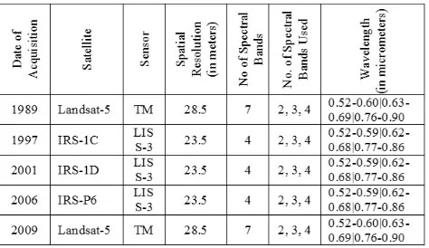
These facts show that standard temporal resolution is not a suitable characteristics of Landsat data in the case of water quality observation.. A real time
Since the ownership of vehicles in urban cities is generally high at present and it is convenient to acquire trajectory data of vehicles, enormous real-time vehicle
The correlation function differs for individual reflectors: the peak is high and thin for the areas on the rock, but it is lower and wider for the areas on the glacier due to
