isprs annals III 3 339 2016
Teks penuh
Gambar
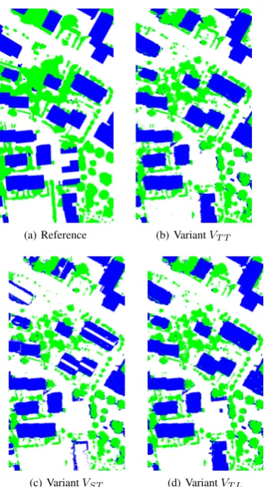
![Figure 2: Overall accuracy [%] for the 36 test pairs, obtained for three classification variants (red: VST ; blue: VT T ; green: VT L)](https://thumb-ap.123doks.com/thumbv2/123dok/3218835.1394991/6.595.62.538.70.208/figure-overall-accuracy-pairs-obtained-classication-variants-green.webp)
Garis besar
Dokumen terkait
Validation was made by comparing the classification results with the ground reference data, which yielded satisfactory agreement with overall accuracy 84.1% and Kappa
Though classification using the same classes (water, flooded vegetation, irrigated fields and non-wetland) on a single dual- pol image was only successful for TerraSAR-X but not
We have demonstrated an object-based classification of high- value crops using an optimized SVM model using LiDAR data and Orthophoto. There are three major parts of the presented
Comparing the result of the proposed method in Figure 4-(a) and post-classification comparison result with 4 different pairs of pre- and post-disaster images in Figure
The contributions of this study are threefold: (1) to develop a spatial-temporal classification framework to discriminate crops using a sequence of multitemporal TerraSAR-X images,
Results shows that using 25 scale segmentation and incorporating suitable texture classification and object-oriented classifiers, it significantly improved the shadowed
This paper exploits the potential of dense multi-image 3d reconstruction of destroyed cultural heritage monuments by either using public domain touristic imagery only or
This paper contributes to landform classification and multiple representation of terrain models by presenting a framework for qualitative description of landforms which could be
