isprsannals II 3 W5 187 2015
Teks penuh
Gambar
Garis besar
Dokumen terkait
In this paper we report results from a qualitative user experiment (n=107) designed to contribute to understanding the impact of various levels of complexity
Our approach is independent on initial values for the unknowns, very robust against outliers in relative rotations and homologous points and reaches good results on syn- thetic as
The proposed method consists of a Dynamic Bayes Network which combines the results of a pedestrian detector, recursive filtering and an instance-specific classifier with online
Using StreetGen for the second time on only one road axis will simply update the parameters of the street model associated with this axis.. Thus, we can guarantee at any time that
Figure 2: Separating nearby buildings: (a) input (non-ground) point cloud data, (b) extracted building footprint (buildings are merged), (c) corresponding building mask, (d)
In this newly simplified approach the user expresses a possibly tolerant selection condition on a quality indicator of a component of the VGI item, by simply stating
When the initial data is symbolized at a scale consistent with its level of detail (Figure 4a), it gives a good idea of the information to preserve, but not for
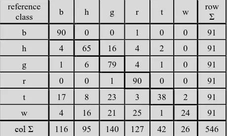
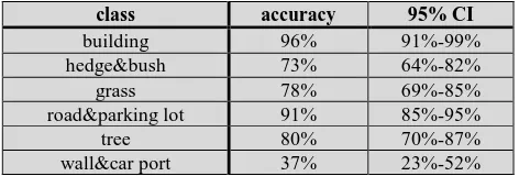
In addition to a land cover validation tool, LACO-Wiki is also intended to become an open access repository for calibration and validation data that can be
