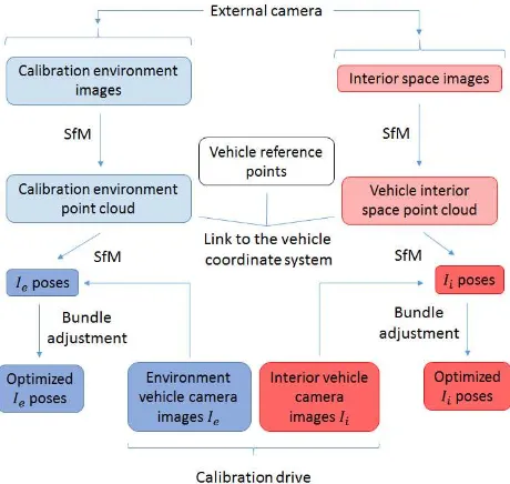
isprs archives XLII 1 W1 181 2017
Teks penuh
Gambar


Garis besar
Dokumen terkait
KEY WORDS: synthetic aperture radar (SAR), optical imagery, remote sensing, data fusion, stereogrammetry, photogrammetry, radargrammetry, 3D reconstruction, multi-sensor
REP can be estimated using different numerical methods such as linear interpolation method, inverted Gaussian technique, three point Lagrange interpolation technique, and
KEY WORDS: Unmanned aerial vehicle, Aerial photography, Inertial navigation system (INS), Accelerometer systematic shift, Gyroscope systematic offset, Position
As derivative features on the spectral information are difficult to use in practice, given the low SNR of bands in the blue range of the spectrum and the low energy The
Similarly, the accuracy assessment of the orientation of linear features used statistical Mean and standard deviation of the difference between the coordinates of road
Flight testing a Real-Time Hazard Detection System for Safe Lunar Landing on the Rocket-Powered Morpheus Vehicle, AIAA Guidance, Navigation, and Control
Aiming at using SGM for image matching of LRO NAC stereo pairs for precision 3D surface reconstruction, this paper presents a coupled epipolar rectification methods for LRO NAC
Obtained results showed that investigated UAS equipped with Velodyne HDL-32E laser scanner can provide point clouds of the absolute 3D position accuracy not worse
