isprs archives XLI B3 685 2016
Teks penuh
Gambar
Garis besar
Dokumen terkait
KEY WORDS: radar vegetation index, RVI, ALOS-2, PALSAR2, crop, biomass, rice, paddy
KEY WORDS: Unmanned aerial vehicle, satellite remote sensing, vegetation indices, winter wheat, site specific crop
KEY WORDS: Crown Delineation , Canopy Height Model (CHM), Local Maxima, Curvature, Slope, Thiessen
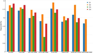
Quantitative performance evaluation is affected by computing the values of five image fusion quality metrics (Tables 3 and 4) : (1) Average Gradient (AG) - average magnitude of
It describes a linear feature as a string of points, represents all features in an image as a configuration of a spatial point process, and formulates feature detection as finding
The main steps of this approach include building segmentation, feature extraction and learning, and finally building roof labeling in a supervised pre-trained Convolutional
For these problems, this paper proposes an automatic road centerlines extraction method which has three major steps: (1) road center point detection based on multiple
KEY WORDS: Mobile Laser Scanning, Point Cloud, Pavement Crack, Automated Detection, Urban
