isprs archives XLI B1 151 2016
Teks penuh
Gambar
Garis besar
Dokumen terkait
Among the producers and users of these aerial systems is often argued that to perform laboratory calibration, because the algorithms of modern digital photogrammetric
In (Molina et al., 2016), the first performance analysis of aerial image orientation and calibration in mapKITE for corridor mapping was performed, based on the
Aerial triangulations with different configuratrions of ground control points (GCP’s) had been calculated, comparing the results of using a camera self-calibration and
Sony Nex 5 camera calibration has been done using software: Image Master Calib, Matlab - Camera Calibrator application and Agisoft Lens.. For the study 2D test fields has
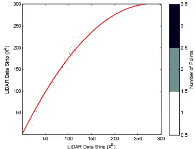
Our approach for 3D feature point extraction from LiDAR data consists of five major steps: (i) generating range images, (ii) corner detection on range images, (iii)
Using three-line arrays image of testing fields, initial exterior orientation parameters and on-orbit calibration camera parameters, the EFP Multi-functional bundle
In the literature that I have seen(HE Min, 2011a)(Miao Hongjie, 2005), in the digital camera calibration, which generally is based on outdoor standardization field or
Performance assessment and in-flight calibration for the satellite RS-2, carrying multiple cameras with widely varying look angles and resolutions, is realized with the inclusion of
