isprsarchives XL 7 W3 975 2015
Teks penuh
Gambar
Garis besar
Dokumen terkait
In this work, the aerosol radiative impact was investigated comparing the reflectance obtained by applying the CHRIS@CRI algorithm with different aerosol models:
(2011 and 2014), surface displacements caused by permafrost thawing can be assessed against surficial geology units and terrain properties (surface materials,
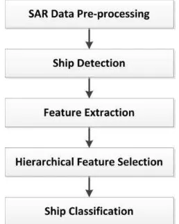
After coordinate transformation and merging of data, candidate landslide representing pixels of high quality radar signals were filtered out by applying a GIS
The theoretical value of brightness temperature under clear sky conditions can be calculated by constructing functions based on the relationship between brightness temperature and
of the Terra/Aqua satellite (“MODIS lines”). The system in eq. 2 is over determined, thus it can be solved by a least-square technique. The geocentric Cartesian coordinates of
The results determine the change of land use/cover and land surface temperature in Danang city by using multi-temporal Landsat and ASTER data for the period of
Recent studies have demonstrated the feasibility of estimate chlorophyll content from hyperspectral vegetation indices composed by the reflectance of specific bands
We demonstrate how this procedure provides realistic 3D urban models in an easy and effective way, by using it to texture a publicly available point cloud from a terrestrial laser
