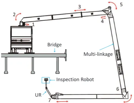
isprs archives XLI B3 527 2016
Teks penuh
Gambar

Garis besar
Dokumen terkait
Therefore, a so-called real image, captured by a smartphone camera, has to be matched with a so-called synthetic image which consists of reverse projected 3D point cloud data to
The concept is similar to the Structure from M otion (SfM ) technique, but the acquisition and data preparation rely on fisheye cameras to generate a vertical
There are multiple methods of segmentation and classification of urban point clouds, but we can at first distinguish between meth- ods using a 2D information (either by projecting
Synthesized and real oblique and vertical aerial imagery is transformed on the one hand into a dense photogrammetric 3D point cloud and on the other hand into photogrammetric
1) The initial building contours are extracted from the classification results of LiDAR point cloud. 2) The internal energy and area energy of the initial contour are
Note that pixels labelled clouds during the cloud detection are not used for computing the median value in the first step; additionally, the NIR input data channel is used to
generation of point cloud from imagery using semi-global image imaging technology, detection of buildings from the generated point cloud, classification of
The entire workflow from the camera calibration to the creation of the 3D point set is discussed, but the focus is mainly on cloud segmentation and on the image
