isprs annals IV 1 W1 107 2017
Teks penuh
Gambar
Garis besar
Dokumen terkait
Furthermore, 3D points in the object space are moved to unit sphere by applying Helmert transformation (three translations and three rotations) between world and
In this paper, spatial and temporal pattern of creep motion at Masouleh landslide were assessed using 3 InSAR time series methods including PSI, SBAS and
Current approaches for facade image segmentation can be classi- fied into two categories: Top-down methods (Gadde et al., 2016, Teboul et al., 2011), which use shape grammars to
To do so, they focused on extracting features from those CNNs features at different layers and used them to label images from two datasets: UC Merced Dataset (UCM) (Yang and
KEY WORDS: Active Learning, Remote Sensing, Land Cover Classification, Segmentation, Hierarchical Clustering, Active
In our experiments, the sub-pixel quantification is obtained by applying sparse repre- sentation using elementary spectra derived from (1) a manually designed spectral library, and
Costas Armenakis (York University) Mahdi Motagh (GFZ Potsdam) Richard Bamler (DLR, Oberpfaffenhofen) Stephan Nebiker (FHNW Basel) Francesca Bovolo (FBK Trento) Nicolas
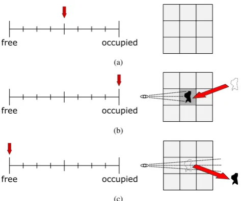
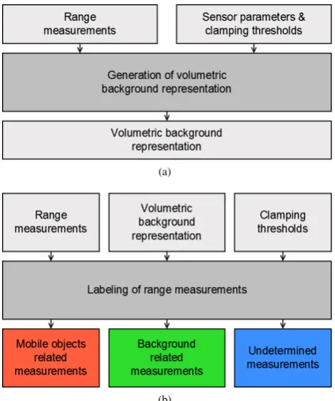
The proposed method is based on the following three steps: extraction of polylines delimiting aboveground objects (e. g., vegetation and buildings) from LiDAR
