isprsarchives XL 7 W3 721 2015
Teks penuh
Gambar


Garis besar
Dokumen terkait
The University of Natural Resources and Life Sciences (BOKU) in cooperation with the National Drought Management Authority (NDMA) has setup an operational processing of MODIS images
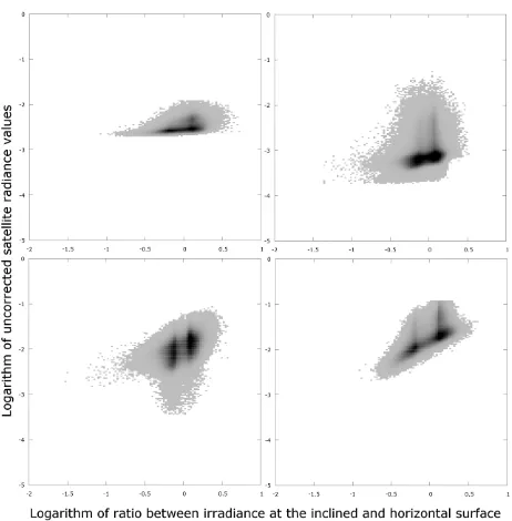
The comparison of Landsat change maps of accumulative annual changes and direct changes between 2005 and 2010 (Table 6) shows the expected pattern: a high error for direct changes
Wide range mosaic map indicating the distribution of natural resources and geographical landscape which can provide a good foundation on large-scale dynamic monitoring
In this study, the PROSPECT model for leaf directional hemi- spherical reflectance has been adapted to the close-range remote- sensing case by adding two parameters describing
The analysis of the reflectance spectra produced by the model also shows that the size of the water droplets in the emulsion is a key parameter in the reflectance spectra shape..
In our study we classified grassland vegetation types of an alkali landscape (Eastern Hungary), using different image classification methods for hyperspectral data.. Our aim was to
The orthophotos were analysed to identify the rock glacier displacements using two different methods: the manual identification of well-recognizable points on
The CA calibration aimed at fitting the parameters in order to simulate a landscape similar to true landscape with regards to the size of the patches of deforestation and its
