isprs archives XLII 3 W2 43 2017
Teks penuh
Gambar

Garis besar
Dokumen terkait
Processing high resolution image sequences through SfM photogrammetry software, a 5cm pixel size orthophoto was produced and was used to identify the rolling section and the
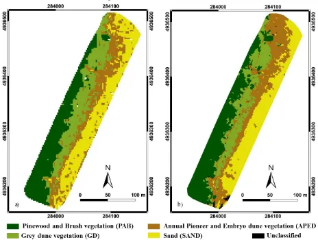
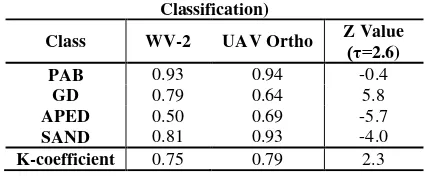
The WorldView-2 DSM was not only used as reference DSM to estimate the accuracy of DSM generated by simulated GF-7 stereo images, but also used as “ ground truth ” to establish
While there has been significant progress in the development of cover data and derived products based on remotely sensed fractional cover information and field data
The International Archives of the Photogrammetry, Remote Sensing and Spatial Information Sciences, Volume XLII-3/W2, 2017 37th International Symposium on Remote Sensing of
Key stages are the allocation of the places for soil sampling points (we used very high resolution space imagery as a supporting data); soil samples collection and analysis;
The evaluation of SAR S1 data sensitivity to the status of farms (cultivated with crops, cultivated without crops and open grassland) through statistical comparison of
In our proposed method, based on classification results in three lidar data, orthophoto and integration features, overall accuracy and omission, commision error
Object- based analyses with segmentation and random forests (RF) classification were then used to investigate the feasibility of the data for land cover
